Supermarket nearby Machesse
Argentina
Supermarket nearby Machesse
Machesse
4429, Guatemala, C1425, C1425BUG, Comuna 14, AR Argentina
contacts phone
:
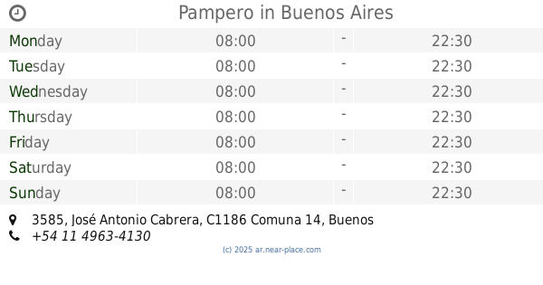
+54
Latitude:
-34.5883163
, Longitude:
-58.4216427
larger map & directions
read more
nearest Supermarket
107 m
Golden Wang Aiquin
Avenida Raúl Scalabrini Ortíz 1925
Supermarket
read more
226 m
Carrefour Express Aráoz 2148
Aráoz 2148
Supermarket
read more
457 m
Supermercado Zhang Yuyun
Güemes 4029
Supermarket
read more
487 m
Supermercado Ji Chaming
Avenida Raúl Scalabrini Ortíz 1554
Supermarket
read more
492 m
Supermercado Palermo
Jorge Luis Borges 2261
Supermarket
read more
555 m
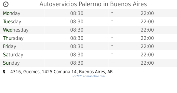
Autoservicios Palermo
Güemes 4316
Supermarket
read more
597 m
COTO
Avenida Santa Fe 3760
Supermarket
read more
608 m
Carrefour Express Charcas 4367
Charcas 4367
Supermarket
read more
614 m
Sky
Gurruchaga 24
Supermarket
read more
645 m
Kiosco Mimi
C1425BKQ, Güemes 3707
Supermarket
read more
778 m
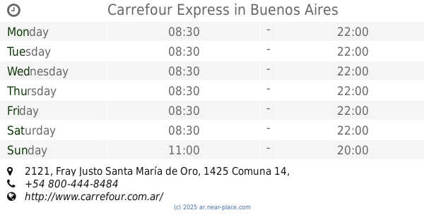
Carrefour Express
Fray Justo Santa María de Oro 2121
Supermarket
read more
791 m
Carrefour Express
C1425FOC, Fray Justo Santa María de Oro 2135
Supermarket
read more
870 m
chino Hasta Tarde
Honduras 3713-3799
Supermarket
read more
876 m
Casa Blanca
Fray Justo Santa María de Oro 2327
Supermarket
read more
907 m
Kiosko
Güemes 4744
Supermarket
read more
913 m
Supermercado Wilson
Jerónimo Salguero 1220
Supermarket
read more
947 m
Carrefour Express
Aráoz 1140
Supermarket
read more
969 m
Chen Hui Yung
Fray Justo Santa María de Oro 2420
Supermarket
read more
1.024 km
Carrefour Express Billinghurst 1380
Billinghurst 1380
Supermarket
read more
1.026 km
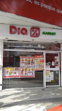
Supermercados DIA
C1414BAE, Avenida Córdoba 4667
Supermarket
read more
1.027 km
Pampero
José Antonio Cabrera 3585
Supermarket
read more
1.099 km
Supermecado XIN
Soler 3435
Supermarket
read more
1.119 km
Lin Long Qin
Avenida General Las Heras 3777
Supermarket
read more
1.142 km
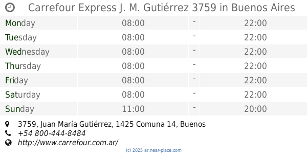
Carrefour Express J. M. Gutiérrez 3759
Juan María Gutiérrez 3759, Buenos Aires
Supermarket
read more
1.175 km
Supermercado Express
Lavalleja 1037
Supermarket
read more
📑
all categories
Accounting
Administrative area level 1
Administrative area level 2
Airport
Amusement park
Aquarium
Art gallery
Atm
Bakery
Bank
Bar
Beauty salon
Bicycle store
Book store
Bowling alley
Bus station
Cafe
Campground
Car dealer
Car rental
Car repair
Car wash
Casino
Cemetery
Church
City hall
Clothing store
Colloquial area
Convenience store
Country
Courthouse
Dentist
Department store
Doctor
Electrician
Electronics store
Embassy
Establishment
Finance
Fire station
Florist
Food
Funeral home
Furniture store
Gas station
General contractor
Grocery or supermarket
Gym
Hair care
Hardware store
Health
Hindu Temple
Home goods store
Hospital
Insurance agency
Intersection
Jewelry store
Laundry
Lawyer
Library
Light rail station
Liquor store
Local government office
Locality
Locksmith
Lodging
Meal delivery
Meal takeaway
Mosque
Movie rental
Movie theater
Moving company
Museum
Natural feature
Neighborhood
Night club
Painter
Park
Parking
Pet store
Pharmacy
Physiotherapist
Place of worship
Plumber
Point of interest
Police
Political
Post office
Premise
Real estate agency
Restaurant
Roofing contractor
Route
Rv park, camping
School
Shoe store
Shopping mall
Spa
Stadium
Storage
Store
Subpremise
Subway station
Supermarket
Synagogue
Taxi stand
Train station
Transit station
Travel agency
University
Veterinary care
Zoo
sublocality level 1
sublocality level 3
↑