Atm nearby ATM
Coronavirus disease (COVID-19) Situation
confirmed cases
10128845
deaths
130841
Argentina
Atm nearby ATM
ATM
Avenida General Las Heras 2401 Argentina
contacts phone
:
+54
Latitude:
-34.5864124
, Longitude:
-58.3981959
read more
nearest Atm
240 m
ATM
C1119ACG, Avenida Pueyrredón 2325
Atm
read more
330 m
Banco Ciudad
C1425ASR, Avenida General Las Heras 2724-2798
Atm
read more
383 m
ATM
1119, Avenida Pueyrredón 1845
Atm
read more
409 m
ATM
Avenida General Las Heras 2111, 1425, C1127AAD, Buenos Aires
Atm
read more
438 m
ATM
Avenida del Libertador 1784, Buenos Aires
Atm
read more
542 m
RAPIPAGO
Avenida General Las Heras 2933
Atm
read more
652 m
Link
Supermercado Disco, Peña 3050
Atm
read more
690 m
privado Elvira
C1112AAC, Ayacucho 1639-1643
Atm
read more
720 m
Banco Ciudad
General Las Heras 3099
Bank
Atm
Finance
Point of interest
Establishment
read more
735 m
ATM
Avenida del Libertador 2196, C1425AAU
Atm
read more
788 m
Terminal Automática Sube
Avenida Alvear 1936
Atm
read more
839 m
Cajero Banelco
C1024AAA, Avenida Callao 1493
Atm
read more
898 m
Banco Galicia
C1024AAR, Avenida Callao 1802-1900
Atm
read more
947 m
Banco Santander
C1024AAE, Avenida Callao 1861
Atm
read more
970 m
ATM
Avenida Santa Fe 2299, C1123AAE
Atm
read more
974 m
Banelco Itau Buen Ayre
Atm
read more
979 m
ATM
Avenida Santa Fe 2265
Atm
read more
988 m
Link
Avenida Santa Fe 2877
Atm
read more
1.018 km
Rapipago
Avenida Santa Fe 3001-3021, C1425BGS
Atm
read more
1.055 km
Banco Ciudad
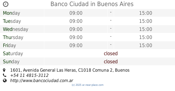
Avenida General Las Heras 1601
Atm
read more
1.056 km
ATM
Avenida Santa Fe 3117, Buenos Aires
Atm
read more
1.07 km
Banelco
Avenida Callao 1117
Atm
read more
1.143 km
Atm Banco Ciudad
Jerónimo Salguero 2701-2729
Atm
read more
1.147 km
ATM
Jerónimo Salguero 2727, 1425, Palermo
Atm
read more
1.275 km
ATM
Avenida del Libertador 2699, C1425AAM
Atm
read more
📑
all categories
Accounting
Administrative area level 1
Administrative area level 2
Airport
Amusement park
Aquarium
Art gallery
Atm
Bakery
Bank
Bar
Beauty salon
Bicycle store
Book store
Bowling alley
Bus station
Cafe
Campground
Car dealer
Car rental
Car repair
Car wash
Casino
Cemetery
Church
City hall
Clothing store
Colloquial area
Convenience store
Country
Courthouse
Dentist
Department store
Doctor
Electrician
Electronics store
Embassy
Establishment
Finance
Fire station
Florist
Food
Funeral home
Furniture store
Gas station
General contractor
Grocery or supermarket
Gym
Hair care
Hardware store
Health
Hindu Temple
Home goods store
Hospital
Insurance agency
Intersection
Jewelry store
Laundry
Lawyer
Library
Light rail station
Liquor store
Local government office
Locality
Locksmith
Lodging
Meal delivery
Meal takeaway
Mosque
Movie rental
Movie theater
Moving company
Museum
Natural feature
Neighborhood
Night club
Painter
Park
Parking
Pet store
Pharmacy
Physiotherapist
Place of worship
Plumber
Point of interest
Police
Political
Post office
Premise
Real estate agency
Restaurant
Roofing contractor
Route
Rv park, camping
School
Shoe store
Shopping mall
Spa
Stadium
Storage
Store
Subpremise
Subway station
Supermarket
Synagogue
Taxi stand
Train station
Transit station
Travel agency
University
Veterinary care
Zoo
sublocality level 1
sublocality level 3
↑