Bakery nearby BLAS PARERA
Coronavirus disease (COVID-19) Situation
confirmed cases
10128845
deaths
130841
Argentina
Bakery nearby BLAS PARERA
BLAS PARERA
2943, French, C1425, Comuna 2, Buenos Aires, AR Argentina
contacts phone
:
+54
Latitude:
-34.587593
, Longitude:
-58.404721
larger map & directions
read more
nearest Bakery
256 m
Galileo
Billinghurst 2315
Bakery
read more
308 m
Saint Honoré
Peña 2665
Bakery
read more
348 m
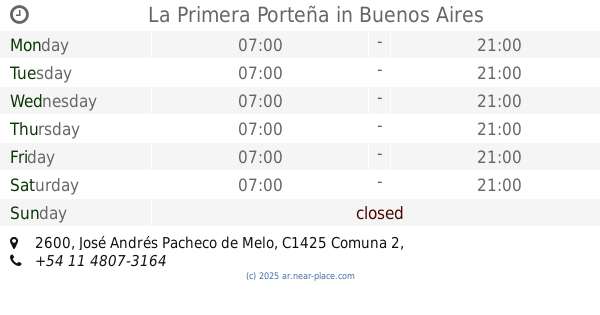
La Primera Porteña
José Andrés Pacheco de Melo 2600
Bakery
read more
382 m
Super Miga
French 2649
Bakery
read more
408 m
Guber Panaderia y Pasteleria
C1425EHW, Agüero 2291
Bakery
read more
510 m
Sans Souci
Avenida Pueyrredón 1974
Bakery
read more
533 m
La Nueva San Agustín
Avenida General Las Heras 2915
Bakery
read more
560 m
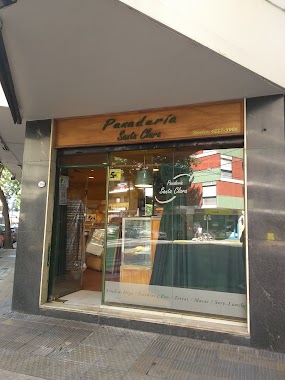
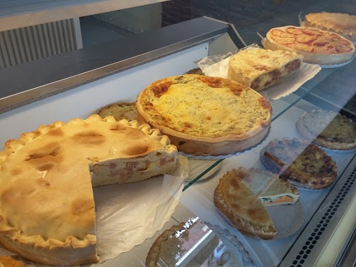
Panadería Santa Clara
Arenales 2699
Bakery
read more
572 m
Amor a cocinar
Barrientos 1550
Bakery
read more
607 m
Divino Budín
Larrea 1472
Bakery
read more
798 m
La felicidad
Charcas 3251, C1425BMO
Bakery
read more
811 m
Fraula
AAE, Avenida General Las Heras 2211, Buenos Aires
Bakery
read more
812 m
Olten
Julián Álvarez 2577
Bakery
read more
837 m
Suevia
Jerónimo Salguero 1944
Bakery
read more
852 m
Emily
C1425BMA, Charcas 2599
Bakery
read more
892 m
Sol de Justicia
Presidente José Evaristo Uriburu 1698
Bakery
read more
910 m
Costumbres Argentinas
Avenida Santa Fe 3534
Bakery
read more
921 m
HOPE MARKET
DHL, Julián Álvarez 2466
Bakery
read more
921 m
Todo Tartas
General Lucio Norberto Mansilla 3410
Bakery
read more
950 m
Mr Miga
Avenida Pueyrredón 1262
Bakery
read more
952 m
Confitería Luis XV
Avenida General Las Heras 2068
Bakery
read more
961 m
Confitería Yaiza
Arenales 2211
Bakery
read more
995 m
Amazing Pastry
C1119ACU, Avenida Pueyrredón 2478
Bakery
read more
1.151 km
Petit Bombon
Billinghurst 1298
Bakery
read more
1.206 km
Lo de Matheo
Billinghurst 1220
Bakery
read more
📑
all categories
Accounting
Administrative area level 1
Administrative area level 2
Airport
Amusement park
Aquarium
Art gallery
Atm
Bakery
Bank
Bar
Beauty salon
Bicycle store
Book store
Bowling alley
Bus station
Cafe
Campground
Car dealer
Car rental
Car repair
Car wash
Casino
Cemetery
Church
City hall
Clothing store
Colloquial area
Convenience store
Country
Courthouse
Dentist
Department store
Doctor
Electrician
Electronics store
Embassy
Establishment
Finance
Fire station
Florist
Food
Funeral home
Furniture store
Gas station
General contractor
Grocery or supermarket
Gym
Hair care
Hardware store
Health
Hindu Temple
Home goods store
Hospital
Insurance agency
Intersection
Jewelry store
Laundry
Lawyer
Library
Light rail station
Liquor store
Local government office
Locality
Locksmith
Lodging
Meal delivery
Meal takeaway
Mosque
Movie rental
Movie theater
Moving company
Museum
Natural feature
Neighborhood
Night club
Painter
Park
Parking
Pet store
Pharmacy
Physiotherapist
Place of worship
Plumber
Point of interest
Police
Political
Post office
Premise
Real estate agency
Restaurant
Roofing contractor
Route
Rv park, camping
School
Shoe store
Shopping mall
Spa
Stadium
Storage
Store
Subpremise
Subway station
Supermarket
Synagogue
Taxi stand
Train station
Transit station
Travel agency
University
Veterinary care
Zoo
sublocality level 1
sublocality level 3
↑