Bakery nearby Marlen
Coronavirus disease (COVID-19) Situation
confirmed cases
10128845
deaths
130841
Argentina
Bakery nearby Marlen
Marlen
3272, Avenida Olazábal, C1428, Comuna 13, Buenos Aires, AR Argentinien
contacts phone
:
+54 11 4545-1190
Latitude:
-34.5652074
, Longitude:
-58.4667238
larger map & directions
read more
nearest Bakery
269 m
Dias de festejos
Avenida Monroe 3144
Bakery
read more
363 m
Rob-gus
Zapiola 2075
Bakery
read more
435 m
PANADERIA 4 SOLES
Echeverría 3087
Bakery
read more
454 m
Aires Belgrano
Mendoza 2894
Bakery
read more
571 m
Panadería Dulce Encuentro
Doctor Pedro Ignacio Rivera 2992
Bakery
read more
589 m
Amapola
C1428CTC, Avenida Crámer 1985
Bakery
read more
657 m
Inocencio
Moldes 2201
Bakery
read more
673 m
The Argentina Bakery and Confectionery
Avenida Crámer 1891
Bakery
read more
673 m
La Argentina Confitería y Panadería
Avenida Crámer 1891
Bakery
read more
700 m
La Flor de Belgrano
Moldes 2498
Bakery
read more
725 m
Panaderia Y Confiteria Nahuel II
Echeverría 2716
Bakery
read more
754 m
Confitería La Capital
Franklin D. Roosevelt 2699
Bakery
read more
766 m
La Favorita
Avenida Olazábal 2583
Bakery
read more
884 m
La Moderna
Juramento 2483
Bakery
read more
884 m
Lujan
Franklin D. Roosevelt 2531
Bakery
read more
896 m
Dulce station
Avenida Olazábal 3998
Bakery
read more
900 m
Lidoro
Avenida Monroe 1499
Bakery
read more
925 m
Peek & Pie
Doctor Pedro Ignacio Rivera 2553, C1428BQC
Bakery
read more
979 m
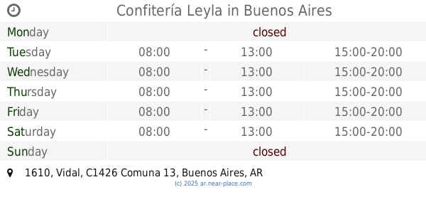
Confitería Leyla
Vidal 1610
Bakery
read more
1.018 km
La Moderna
Avenida Cabildo 2529
Bakery
read more
1.043 km
Choklad Coffee and Patisserie
AUE, Zapiola 1575
Bakery
read more
1.102 km
Instituto Cecilia Morana
Virrey Avilés 3007
Bakery
read more
1.174 km
Panadería Santa Ana
Conde 1502
Bakery
read more
1.18 km
Puerto Dulce
Cuba 2484
Bakery
read more
1.351 km
Boqueria Mercado Gourmet
Cap. Gral. Ramón Freire & Virrey Arredondo
Bakery
read more
📑
all categories
Accounting
Administrative area level 1
Administrative area level 2
Airport
Amusement park
Aquarium
Art gallery
Atm
Bakery
Bank
Bar
Beauty salon
Bicycle store
Book store
Bowling alley
Bus station
Cafe
Campground
Car dealer
Car rental
Car repair
Car wash
Casino
Cemetery
Church
City hall
Clothing store
Colloquial area
Convenience store
Country
Courthouse
Dentist
Department store
Doctor
Electrician
Electronics store
Embassy
Establishment
Finance
Fire station
Florist
Food
Funeral home
Furniture store
Gas station
General contractor
Grocery or supermarket
Gym
Hair care
Hardware store
Health
Hindu Temple
Home goods store
Hospital
Insurance agency
Intersection
Jewelry store
Laundry
Lawyer
Library
Light rail station
Liquor store
Local government office
Locality
Locksmith
Lodging
Meal delivery
Meal takeaway
Mosque
Movie rental
Movie theater
Moving company
Museum
Natural feature
Neighborhood
Night club
Painter
Park
Parking
Pet store
Pharmacy
Physiotherapist
Place of worship
Plumber
Point of interest
Police
Political
Post office
Premise
Real estate agency
Restaurant
Roofing contractor
Route
Rv park, camping
School
Shoe store
Shopping mall
Spa
Stadium
Storage
Store
Subpremise
Subway station
Supermarket
Synagogue
Taxi stand
Train station
Transit station
Travel agency
University
Veterinary care
Zoo
sublocality level 1
sublocality level 3
↑