Bakery nearby Panadería Confitería Nogueira
Argentina
Bakery nearby Panadería Confitería Nogueira
Panadería Confitería Nogueira
1492, Curapaligüe, Comuna 7, Buenos Aires, AR Argentina
contacts phone
:
+54
Latitude:
-34.6393871
, Longitude:
-58.4444653
larger map & directions
read more
nearest Bakery
7 m
Panadería Confitería Nogueira
Argentina
Bakery
read more
287 m
Repostería Coreana Manna
Avenida Carabobo 1590
Bakery
read more
517 m
Santina
Av. Asamblea 1130, Local 2
Bakery
read more
518 m
Las Delicias de Flor
Curapaligüe 1025
Bakery
read more
559 m
Los Leopoldo
Avenida Coronel Esteban Bonorino 1301
Bakery
read more
563 m
Los Leopoldo
Santander 2302
Bakery
read more
611 m
Nueva Sissi
Malvinas Argentinas 971
Bakery
read more
670 m
La Casa de La Miel
Emilio Mitre 1307
Bakery
read more
740 m
La Prometida
Avenida Cobo 1598
Bakery
read more
744 m
La Central Chacabuco
Avenida Asamblea 945
Bakery
read more
760 m
La Nueva Dalma
Crespo 2028
Bakery
read more
763 m
Que Bueno
Cachimayo 1497
Bakery
read more
797 m
Del Rosal
Avenida Eva Perón 2251
Bakery
read more
797 m
Confitería Federico
Baldomero Fernández Moreno 1637
Bakery
read more
826 m
Panaderia y Confiteria El Sol
Avenida Carabobo 802
Bakery
read more
838 m
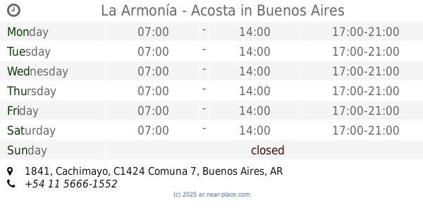
La Armonía - Acosta
C1424ARW, Cachimayo 1841
Bakery
read more
873 m
Panadería La Milagrosa
Avenida Asamblea 848
Bakery
read more
888 m
Boulevard Saenz II
Puan 752
Bakery
read more
911 m
La Casa De Maga
Emilio Mitre 900
Bakery
read more
932 m
Panaderia-Confiteria Luisito Sandwhiches
Picheuta 1690
Bakery
read more
971 m
San Pablo
Emilio Mitre 300
Bakery
read more
979 m
Le Petit
Avenida del Barco Centenera 1254
Bakery
read more
1.023 km
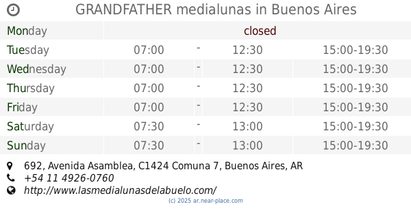
GRANDFATHER medialunas
Avenida Asamblea 692
Bakery
read more
1.044 km
CONFITERÍA - PANADERÍA LA CANOA
Avenida Varela 1257
Bakery
read more
1.289 km
Panaderia Olga
Agustín de Vedia 2402
Bakery
read more
📑
all categories
Accounting
Administrative area level 1
Administrative area level 2
Airport
Amusement park
Aquarium
Art gallery
Atm
Bakery
Bank
Bar
Beauty salon
Bicycle store
Book store
Bowling alley
Bus station
Cafe
Campground
Car dealer
Car rental
Car repair
Car wash
Casino
Cemetery
Church
City hall
Clothing store
Colloquial area
Convenience store
Country
Courthouse
Dentist
Department store
Doctor
Electrician
Electronics store
Embassy
Establishment
Finance
Fire station
Florist
Food
Funeral home
Furniture store
Gas station
General contractor
Grocery or supermarket
Gym
Hair care
Hardware store
Health
Hindu Temple
Home goods store
Hospital
Insurance agency
Intersection
Jewelry store
Laundry
Lawyer
Library
Light rail station
Liquor store
Local government office
Locality
Locksmith
Lodging
Meal delivery
Meal takeaway
Mosque
Movie rental
Movie theater
Moving company
Museum
Natural feature
Neighborhood
Night club
Painter
Park
Parking
Pet store
Pharmacy
Physiotherapist
Place of worship
Plumber
Point of interest
Police
Political
Post office
Premise
Real estate agency
Restaurant
Roofing contractor
Route
Rv park, camping
School
Shoe store
Shopping mall
Spa
Stadium
Storage
Store
Subpremise
Subway station
Supermarket
Synagogue
Taxi stand
Train station
Transit station
Travel agency
University
Veterinary care
Zoo
sublocality level 1
sublocality level 3
↑