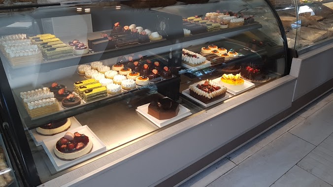
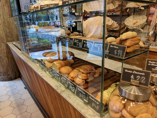
Bakery nearby Sweet Maquita Patisserie
Coronavirus disease (COVID-19) Situation
confirmed cases
10128845
deaths
130841
Argentina
Bakery nearby Sweet Maquita Patisserie
Sweet Maquita Patisserie
Avenida Luis Maria Campos 318, 3ro , "C", C1426BOO Ciudad Autonoma de Buenos Aires, Buenos Aires, Argentina
contacts phone
:
+54 11 3241-4137
Latitude:
-34.573514
, Longitude:
-58.432652
larger map & directions
read more
nearest Bakery
377 m
Agalma Cakes
República de Eslovenia 1917
Bakery
read more
387 m
Buenos Aires Bakery
C1426BSH, Arce 502
Bakery
read more
473 m
Panfe S.R.L.
Teniente Benjamín Matienzo 1987
Bakery
read more
512 m
El Artesano Confiteria
Báez 709
Bakery
read more
572 m
Pizzas PBT
Ángel Justiniano Carranza 2204
Bakery
read more
575 m
Despacho de Pan Santos Dumunt
Santos Dumont 2443
Bakery
read more
588 m
Panadería Bellaria
Teniente Benjamín Matienzo 1744
Bakery
read more
594 m
Manggini Panadería
Avenida Luis María Campos 799, C1426BOD
Bakery
read more
601 m
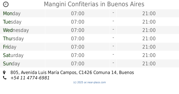
Mangini Confiterias
Avenida Luis María Campos 805
Bakery
read more
607 m
Hausbrot
Jumbo Supermercado, Avenida Intendente Bullrich 345
Bakery
read more
715 m
Don Blanco
Arévalo & Nicaragua
Bakery
read more
721 m
Panadería Don Blanco
Nicaragua 6000
Bakery
read more
735 m
Don Blanco Pastelería
Arévalo 1989
Bakery
read more
747 m
Le Ble
Avenida del Libertador 4502
Bakery
read more
783 m
Hausbrot
Maure 1771
Bakery
read more
834 m
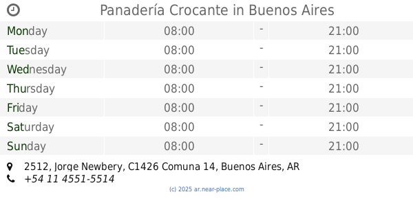
Panadería Crocante
Jorge Newbery 2512
Bakery
read more
881 m
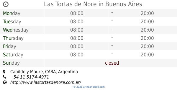
Las Tortas de Nore
Cabildo y Maure, Buenos Aires
Bakery
read more
893 m
Pansito
C1425FQM, Godoy Cruz 2803
Bakery
read more
932 m
Boûlan
Sinclair 3196
Bakery
read more
937 m
So Bagel
Paraguay 4979
Bakery
read more
975 m
San Marcos
Fray Justo Santa María de Oro 2514
Bakery
read more
984 m
Hotel Pacifico
Fray Justo Santa María de Oro 2554
Bakery
read more
1.15 km
Mamía
Soldado de la Independencia 1177
Bakery
read more
1.188 km
Tartas Crams
Avenida Luis María Campos 1226, C1426BOX
Bakery
read more
1.315 km
Don Armando
Thames 2451
Bakery
read more
📑
all categories
Accounting
Administrative area level 1
Administrative area level 2
Airport
Amusement park
Aquarium
Art gallery
Atm
Bakery
Bank
Bar
Beauty salon
Bicycle store
Book store
Bowling alley
Bus station
Cafe
Campground
Car dealer
Car rental
Car repair
Car wash
Casino
Cemetery
Church
City hall
Clothing store
Colloquial area
Convenience store
Country
Courthouse
Dentist
Department store
Doctor
Electrician
Electronics store
Embassy
Establishment
Finance
Fire station
Florist
Food
Funeral home
Furniture store
Gas station
General contractor
Grocery or supermarket
Gym
Hair care
Hardware store
Health
Hindu Temple
Home goods store
Hospital
Insurance agency
Intersection
Jewelry store
Laundry
Lawyer
Library
Light rail station
Liquor store
Local government office
Locality
Locksmith
Lodging
Meal delivery
Meal takeaway
Mosque
Movie rental
Movie theater
Moving company
Museum
Natural feature
Neighborhood
Night club
Painter
Park
Parking
Pet store
Pharmacy
Physiotherapist
Place of worship
Plumber
Point of interest
Police
Political
Post office
Premise
Real estate agency
Restaurant
Roofing contractor
Route
Rv park, camping
School
Shoe store
Shopping mall
Spa
Stadium
Storage
Store
Subpremise
Subway station
Supermarket
Synagogue
Taxi stand
Train station
Transit station
Travel agency
University
Veterinary care
Zoo
sublocality level 1
sublocality level 3
↑