Bar nearby Aramburu Ünder
Argentina
Bar nearby Aramburu Ünder
Aramburu Ünder
1207, Humberto 1º, C1103, Comuna 1, Buenos Aires, AR Argentina
contacts phone
:
+54
Latitude:
-34.6209814
, Longitude:
-58.3830861
larger map & directions
read more
nearest Bar
548 m
Cuarto Apóstol
Piedras 1040
Bar
read more
576 m
Charly
Pavón 1299
Bar
read more
624 m
El Fronteo Bar&Lounge
México 1158, C1097AAX
Bar
read more
710 m
Canelo
Estados Unidos 701
Bar
read more
736 m
Que Nadie Sepa
Chacabuco 860
Bar
read more
767 m
Eclipse Drink
México 1558
Bar
read more
813 m
La Habanilla
San Telmo - Perú 1016, Buenos Aires, Autonomous City of Buenos Aires
Bar
read more
824 m
Saint Elmo
Perú 1118
Bar
read more
837 m
Santo Remedio
Chile 700
Bar
read more
904 m
Mi Breank
Pres. Luis Sáenz Penña 1500
Bar
read more
910 m
Santa Lucía
Avenida San Juan 1899
Bar
read more
916 m
Bar Clásico
C1103ACK, Humberto 1º 501, C1103ACK
Bar
read more
939 m
El Mesón de San Telmo
C1066AAV, Bolívar 1026
Bar
read more
943 m
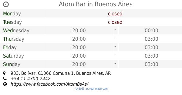
Atom Bar
C1066AAS, Bolívar 933
Bar
read more
948 m
Moira Morena
Chacabuco 573
Bar
read more
981 m
Rotisería Miramar
Avenida San Juan 1999
Bar
read more
983 m
La Francesa
Moreno 1326, C1091ABB
Bar
read more
986 m
Bar del Mercado
Bolívar 970
Bar
read more
986 m
Las Mazorcas
Bolívar 970
Bar
read more
988 m
Restaurante Morriña porteña
Estados Unidos 482
Bar
read more
1.01 km
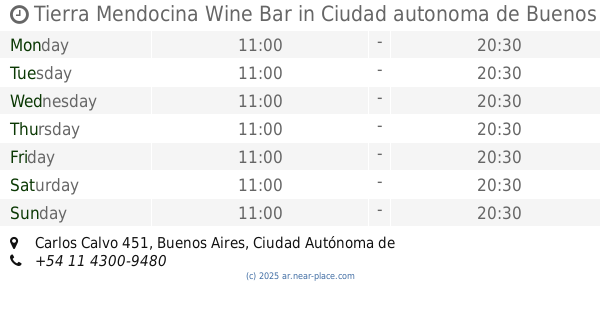
Tierra Mendocina Wine Bar
Carlos Calvo 451, Buenos Aires, Ciudad Autónoma de Buenos Aires, Ciudad autonoma de Buenos aires
Bar
read more
1.032 km
Bar Cervecería Patagonia
México 598
Bar
read more
1.034 km
Patagonia
Perú 618
Bar
read more
1.104 km
Cafe Guglielmo
C1098AAI, Chile 471, Buenos Aires
Bar
read more
1.193 km
BAR Sofía
Combate de los Pozos 443
Bar
read more
📑
all categories
Accounting
Administrative area level 1
Administrative area level 2
Airport
Amusement park
Aquarium
Art gallery
Atm
Bakery
Bank
Bar
Beauty salon
Bicycle store
Book store
Bowling alley
Bus station
Cafe
Campground
Car dealer
Car rental
Car repair
Car wash
Casino
Cemetery
Church
City hall
Clothing store
Colloquial area
Convenience store
Country
Courthouse
Dentist
Department store
Doctor
Electrician
Electronics store
Embassy
Establishment
Finance
Fire station
Florist
Food
Funeral home
Furniture store
Gas station
General contractor
Grocery or supermarket
Gym
Hair care
Hardware store
Health
Hindu Temple
Home goods store
Hospital
Insurance agency
Intersection
Jewelry store
Laundry
Lawyer
Library
Light rail station
Liquor store
Local government office
Locality
Locksmith
Lodging
Meal delivery
Meal takeaway
Mosque
Movie rental
Movie theater
Moving company
Museum
Natural feature
Neighborhood
Night club
Painter
Park
Parking
Pet store
Pharmacy
Physiotherapist
Place of worship
Plumber
Point of interest
Police
Political
Post office
Premise
Real estate agency
Restaurant
Roofing contractor
Route
Rv park, camping
School
Shoe store
Shopping mall
Spa
Stadium
Storage
Store
Subpremise
Subway station
Supermarket
Synagogue
Taxi stand
Train station
Transit station
Travel agency
University
Veterinary care
Zoo
sublocality level 1
sublocality level 3
↑