Bar nearby Bar del conti
Coronavirus disease (COVID-19) Situation
confirmed cases
10128845
deaths
130841
Argentina
Bar nearby Bar del conti
Bar del conti
8151, Avenida del Libertador, C1429, Comuna 13, Buenos Aires, AR Argentina
contacts phone
:
+54
website:
conti.derhuman.jus.gov.ar
Latitude:
-34.54587
, Longitude:
-58.452266
larger map & directions
read more
nearest Bar
370 m
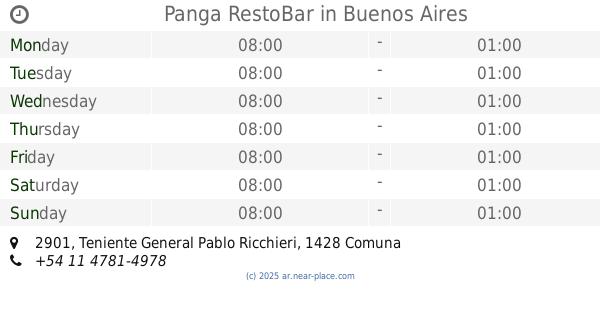
Panga RestoBar
Teniente General Pablo Ricchieri 2901
Bar
read more
466 m
Folia (Disco)
Avenida Crisólogo Larralde 1041
Bar
read more
536 m
Hollybeer
Montañeses 2901, Buenos Aires
Bar
read more
600 m
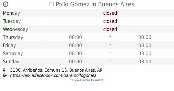
El Pollo Gómez
Arribeños 3100
Bar
read more
649 m
Maldita Birra
Avenida Congreso 1620
Bar
read more
703 m
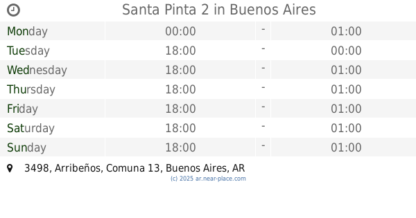
Santa Pinta 2
Arribeños 3498
Bar
read more
727 m
Pizzuela Pizza&Resto
11 de Septiembre de 1888 3000
Bar
read more
780 m
Bar Dos Leones
Avenida Monroe 1438
Bar
read more
782 m
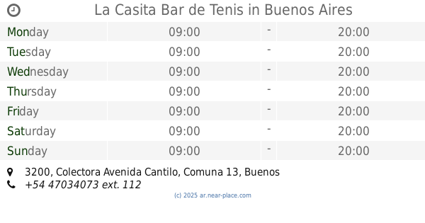
La Casita Bar de Tenis
Colectora Avenida Cantilo 3200
Bar
read more
841 m
Francis Platz
Quesada 1892, Buenos Aires
Bar
read more
841 m
Francis Platz
Quesada 1892
Bar
read more
842 m
Cervecería Stammtisch
Manuela Pedraza 1810
Bar
read more
842 m
Cervecha
Manuela Pedraza 1810, C1429CBH
Bar
read more
863 m
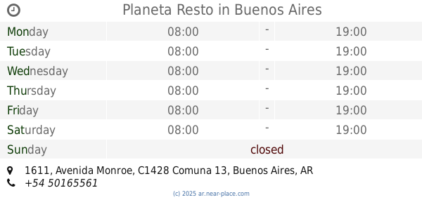
Planeta Resto
Avenida Monroe 1611
Bar
read more
876 m
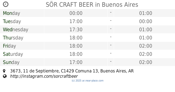
SÖR CRAFT BEER
11 de Septiembre 3673
Bar
read more
876 m
Castro Tabaquería
Avenida Monroe 1625
Bar
read more
908 m
Taco Box
3 de Febrero 2802
Bar
read more
925 m
Trois Cafe Bar
3 de Febrero 2783
Bar
read more
939 m
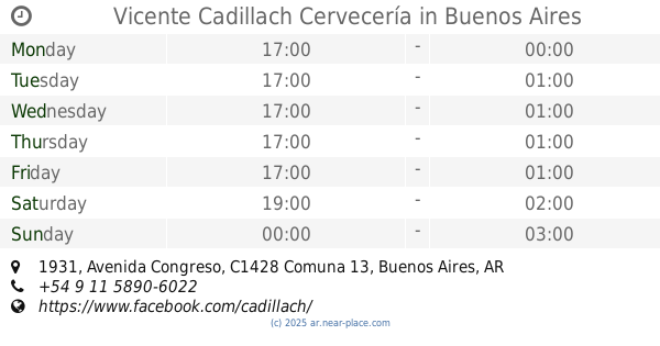
Vicente Cadillach Cervecería
Avenida Congreso 1931
Bar
read more
940 m
Otro Mundo Cervecería
Grecia 3394
Bar
read more
1.042 km
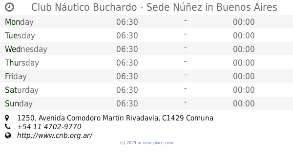
Club Náutico Buchardo - Sede Núñez
Avenida Comodoro Martín Rivadavia 1250
Bar
read more
1.06 km
Byra
Manuela Pedraza 2001
Bar
read more
1.066 km
North Wind (Tango)
Avenida Comodoro Martín Rivadavia 1350
Bar
read more
1.077 km
Luzmala Bar
Arcos 2950
Bar
read more
1.097 km
Casa Babel Bistro
C1428DJG, Mendoza 1267
Bar
read more
📑
all categories
Accounting
Administrative area level 1
Administrative area level 2
Airport
Amusement park
Aquarium
Art gallery
Atm
Bakery
Bank
Bar
Beauty salon
Bicycle store
Book store
Bowling alley
Bus station
Cafe
Campground
Car dealer
Car rental
Car repair
Car wash
Casino
Cemetery
Church
City hall
Clothing store
Colloquial area
Convenience store
Country
Courthouse
Dentist
Department store
Doctor
Electrician
Electronics store
Embassy
Establishment
Finance
Fire station
Florist
Food
Funeral home
Furniture store
Gas station
General contractor
Grocery or supermarket
Gym
Hair care
Hardware store
Health
Hindu Temple
Home goods store
Hospital
Insurance agency
Intersection
Jewelry store
Laundry
Lawyer
Library
Light rail station
Liquor store
Local government office
Locality
Locksmith
Lodging
Meal delivery
Meal takeaway
Mosque
Movie rental
Movie theater
Moving company
Museum
Natural feature
Neighborhood
Night club
Painter
Park
Parking
Pet store
Pharmacy
Physiotherapist
Place of worship
Plumber
Point of interest
Police
Political
Post office
Premise
Real estate agency
Restaurant
Roofing contractor
Route
Rv park, camping
School
Shoe store
Shopping mall
Spa
Stadium
Storage
Store
Subpremise
Subway station
Supermarket
Synagogue
Taxi stand
Train station
Transit station
Travel agency
University
Veterinary care
Zoo
sublocality level 1
sublocality level 3
↑