Bar nearby Club Teléfonos Padel
Argentina
Bar nearby Club Teléfonos Padel
Club Teléfonos Padel
4535, Avenida Fernando Fader, Córdoba, Capital, AR Argentina
contacts phone
:
+54 351 546-4613
Latitude:
-31.369011
, Longitude:
-64.2402197
larger map & directions
read more
nearest Bar
395 m
Peñon Cervecería
X5009CEG, Luis de Tejeda 4455, Córdoba
Bar
read more
396 m
Lugar Secreto
José Roque Funes 1706-1798, X5009LFT
Bar
read more
422 m
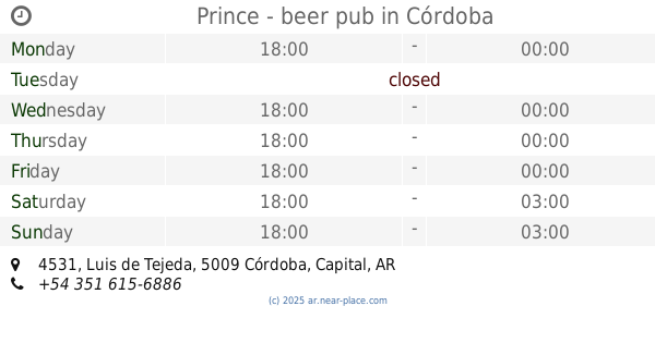
Prince - beer pub
Luis de Tejeda 4531, Córdoba
Bar
read more
427 m
Unranchito
Avenida Hugo Wast 4599-4559, Córdoba
Bar
read more
509 m
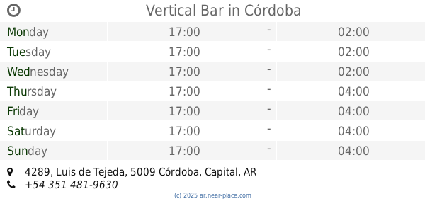
Vertical Bar
Luis de Tejeda 4289, Córdoba
Bar
read more
597 m
Panicafe
X5009LDF, Gregorio Y. Gavier 2084, Córdoba
Bar
read more
632 m
Caceratto
X5009CFX, Avenida Rafael Núñez 4315, Córdoba
Bar
read more
632 m
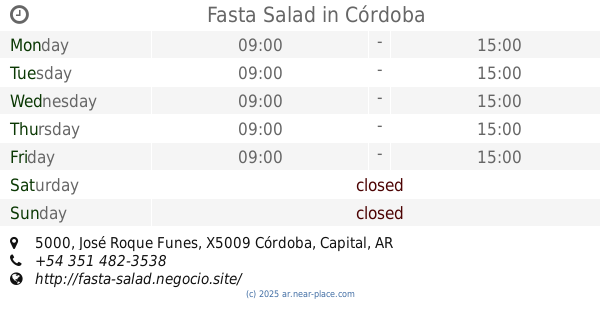
Fasta Salad
2085, LGC, LGC, José Roque Funes 5000, Córdoba
Bar
read more
640 m
Cuatro Catorce Tejeda
Luis de Tejeda 4201, Córdoba
Bar
read more
656 m
Bowling Stroker
Avenida Rafael Núñez 4615, Córdoba
Bar
read more
700 m
Rock your Beer
4155, Luis de Tejeda, Córdoba
Bar
read more
752 m
Antares Cerro
Av. Rafael Núñez 4226, Córdoba
Bar
read more
757 m
Bendito
Avenida Rafael Núñez 4227, cordoba capital
Bar
read more
818 m
Johnny B. Good
Candonga 2108, Córdoba
Bar
read more
842 m
La Esquina De Tejeda
Luis de Tejeda 4050 5000, Córdoba
Bar
read more
877 m
Bar Apolinario
Apolinario Rivas 1315, Córdoba
Bar
read more
970 m
Johnny B.Good
Avenida Rafael Nuñez 4791, Córdoba
Bar
read more
975 m
Shanti
Av. Rafael Núñez 4005, Córdoba
Bar
read more
986 m
A
Juan de Avila y Zárate, Córdoba
Bar
read more
989 m
Maracuyá bar
Juan de Avila y Zárate 2138, Córdoba
Bar
read more
991 m
Nuñez Restó
5009, Avenida Rafael Núñez 3960, Córdoba
Bar
read more
1.01 km
Baxter Lounge
Luis de Tejeda 3961, Córdoba
Bar
read more
1.045 km
Papanato Bar De Papas
Luis de Tejeda, esquina, Roque Ferreyra, Córdoba
Bar
read more
1.116 km
Espacio TEJEDA
Luis de Tejeda 3911, Córdoba
Bar
read more
1.128 km
San Quirico Cafe
Luis de Tejeda 3911, Córdoba
Bar
read more
📑
all categories
Accounting
Administrative area level 1
Administrative area level 2
Airport
Amusement park
Aquarium
Art gallery
Atm
Bakery
Bank
Bar
Beauty salon
Bicycle store
Book store
Bowling alley
Bus station
Cafe
Campground
Car dealer
Car rental
Car repair
Car wash
Casino
Cemetery
Church
City hall
Clothing store
Colloquial area
Convenience store
Country
Courthouse
Dentist
Department store
Doctor
Electrician
Electronics store
Embassy
Establishment
Finance
Fire station
Florist
Food
Funeral home
Furniture store
Gas station
General contractor
Grocery or supermarket
Gym
Hair care
Hardware store
Health
Hindu Temple
Home goods store
Hospital
Insurance agency
Intersection
Jewelry store
Laundry
Lawyer
Library
Light rail station
Liquor store
Local government office
Locality
Locksmith
Lodging
Meal delivery
Meal takeaway
Mosque
Movie rental
Movie theater
Moving company
Museum
Natural feature
Neighborhood
Night club
Painter
Park
Parking
Pet store
Pharmacy
Physiotherapist
Place of worship
Plumber
Point of interest
Police
Political
Post office
Premise
Real estate agency
Restaurant
Roofing contractor
Route
Rv park, camping
School
Shoe store
Shopping mall
Spa
Stadium
Storage
Store
Subpremise
Subway station
Supermarket
Synagogue
Taxi stand
Train station
Transit station
Travel agency
University
Veterinary care
Zoo
sublocality level 1
sublocality level 3
↑