Bar nearby DUCATI
Coronavirus disease (COVID-19) Situation
confirmed cases
10128845
deaths
130841
Argentina
Bar nearby DUCATI
DUCATI
Avenida Cerviño, Comuna 14, Buenos Aires, AR Argentina
contacts phone
:
+54
Latitude:
-34.5779952
, Longitude:
-58.4184854
larger map & directions
read more
nearest Bar
299 m
Bordo Pub
República de la India 2895
Bar
read more
415 m
Expo Ferni
C1425BDA, Antonio Beruti 4449
Bar
read more
473 m
Smash
Avenida Santa Fe 4210
Bar
read more
534 m
Mazunte Bar Cafe
Jorge Luis Borges 2473 loc 36
Bar
read more
539 m
Restaurant Humberto Pejeda
Avenida Santa Fe 4448
Bar
read more
547 m
PIBÄ Cerviño
Avenida Cerviño 3833
Bar
read more
649 m
Chata
Güemes 4800-4702
Bar
read more
671 m
La Jungla
Güemes 4744,C1425BNT
Bar
read more
694 m
El Rápido
Godoy Cruz 2623
Bar
read more
862 m
Berkana
Godoy Cruz 2481
Bar
read more
876 m
Avant Garten
Avenida del Libertador 3883
Bar
read more
879 m
Estación Tacuara
Aráoz 2785
Bar
read more
882 m
WOODS STA.
Av libertador 3883 arco 5
Bar
read more
897 m
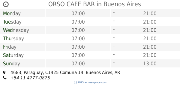
ORSO CAFE BAR
Paraguay 4683
Bar
read more
901 m
Wine Tasting in Buenos Aires
Thames 2228
Bar
read more
917 m
Queseria de Mi
Humboldt 2485, Buenos Aires
Bar
read more
1.018 km
Paralelo Bar
Julián Álvarez 2492
Bar
read more
1.048 km
Bo Bo (
[email protected]
)
Guatemala 4870/82
Bar
read more
1.068 km
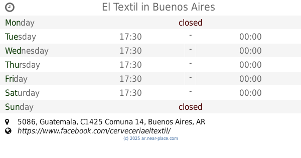
El Textil
Guatemala 5086
Bar
read more
1.069 km
Rabieta
Avenida del Libertador 3949
Bar
read more
1.087 km
Juegos caye quinta estacion
C1425FFA, Jorge Luis Borges 2055
Bar
read more
1.14 km
La Boqueria Grill
Soler 5101
Bar
read more
1.234 km
Sintaxis Palermo
Nicaragua 4849
Bar
read more
1.269 km
POST St. BAR
Thames 1885
Bar
read more
1.371 km
Estilo Isleño | Cervecería
Costa Rica 4875
Bar
read more
📑
all categories
Accounting
Administrative area level 1
Administrative area level 2
Airport
Amusement park
Aquarium
Art gallery
Atm
Bakery
Bank
Bar
Beauty salon
Bicycle store
Book store
Bowling alley
Bus station
Cafe
Campground
Car dealer
Car rental
Car repair
Car wash
Casino
Cemetery
Church
City hall
Clothing store
Colloquial area
Convenience store
Country
Courthouse
Dentist
Department store
Doctor
Electrician
Electronics store
Embassy
Establishment
Finance
Fire station
Florist
Food
Funeral home
Furniture store
Gas station
General contractor
Grocery or supermarket
Gym
Hair care
Hardware store
Health
Hindu Temple
Home goods store
Hospital
Insurance agency
Intersection
Jewelry store
Laundry
Lawyer
Library
Light rail station
Liquor store
Local government office
Locality
Locksmith
Lodging
Meal delivery
Meal takeaway
Mosque
Movie rental
Movie theater
Moving company
Museum
Natural feature
Neighborhood
Night club
Painter
Park
Parking
Pet store
Pharmacy
Physiotherapist
Place of worship
Plumber
Point of interest
Police
Political
Post office
Premise
Real estate agency
Restaurant
Roofing contractor
Route
Rv park, camping
School
Shoe store
Shopping mall
Spa
Stadium
Storage
Store
Subpremise
Subway station
Supermarket
Synagogue
Taxi stand
Train station
Transit station
Travel agency
University
Veterinary care
Zoo
sublocality level 1
sublocality level 3
↑