Bar nearby El Parque
Argentina
Bar nearby El Parque
El Parque
854, Emilio Mitre, C1424, Comuna 7, Buenos Aires, AR Argentinien
contacts phone
:
+54 11 4328-7830
Latitude:
-34.631233
, Longitude:
-58.441903
larger map & directions
read more
nearest Bar
150 m
EL TORO DO BAR BAR
Zuviría 999
Bar
read more
387 m
Cerveza Hormiga Negra Caballito
843, CII, Avenida Directorio
Bar
read more
520 m
Antares Callito
Avenida Pedro Goyena 1100-1054, Buenos Aires
Bar
read more
578 m
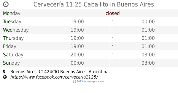
Cervecería 11.25
Bar
read more
578 m
Cervecería 11.25 Caballito
Bar
read more
672 m
La Estancia
Malvinas Argentinas 518
Bar
read more
673 m
Anoeta Bar
José Bonifacio 641
Bar
read more
698 m
Vinoteca Sabores
Avenida Asamblea 653
Bar
read more
790 m
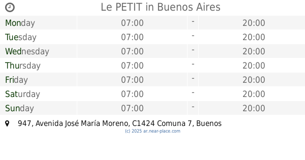
Le PETIT
C1424AAJ, Avenida José María Moreno 947
Bar
read more
790 m
Velvet Bar
Avenida Directorio 513
Bar
read more
855 m
Bánova, Heladería y Cafetería
Av. Juan Bautista Alberdi 1202
Bar
read more
865 m
Tomapavó Resto Bar
Avenida José María Moreno 1293
Bar
read more
865 m
S*LAY Resto-pub Cervezaria
Avenida José María Moreno 1293, C1424AAM
Bar
read more
892 m
dBox
C1424BSF, Avenida Pedro Goyena 515
Bar
read more
936 m
Vittorio Resto Bar
Avenida del Barco Centenera 295
Bar
read more
937 m
Balbastro
Balbastro
Bar
read more
947 m
Rusticana
Avenida Juan Bautista Alberdi 1099
Bar
read more
973 m
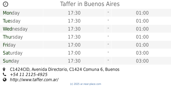
Taffer
391, CID C1424CID C1424 CABA AR, Avenida Directorio, Buenos Aires
Bar
read more
975 m
Taffer
391, CID, Avenida Directorio C1424CID, Buenos Aires
Bar
read more
1.022 km
Brauhausbvier
Beauchef 701-799, C1424BDO
Bar
read more
1.061 km
Richard Parker
Avenida Rivadavia 5799
Bar
read more
1.074 km
Akimekedo
C1424AFG, Riglos 351
Bar
read more
1.08 km
Capriccio
Avenida Pedro Goyena 358
Bar
read more
1.095 km
Auto DANI
Avenida Rivadavia 6015
Bar
read more
1.293 km
Josefina
Viel 524
Bar
read more
📑
all categories
Accounting
Administrative area level 1
Administrative area level 2
Airport
Amusement park
Aquarium
Art gallery
Atm
Bakery
Bank
Bar
Beauty salon
Bicycle store
Book store
Bowling alley
Bus station
Cafe
Campground
Car dealer
Car rental
Car repair
Car wash
Casino
Cemetery
Church
City hall
Clothing store
Colloquial area
Convenience store
Country
Courthouse
Dentist
Department store
Doctor
Electrician
Electronics store
Embassy
Establishment
Finance
Fire station
Florist
Food
Funeral home
Furniture store
Gas station
General contractor
Grocery or supermarket
Gym
Hair care
Hardware store
Health
Hindu Temple
Home goods store
Hospital
Insurance agency
Intersection
Jewelry store
Laundry
Lawyer
Library
Light rail station
Liquor store
Local government office
Locality
Locksmith
Lodging
Meal delivery
Meal takeaway
Mosque
Movie rental
Movie theater
Moving company
Museum
Natural feature
Neighborhood
Night club
Painter
Park
Parking
Pet store
Pharmacy
Physiotherapist
Place of worship
Plumber
Point of interest
Police
Political
Post office
Premise
Real estate agency
Restaurant
Roofing contractor
Route
Rv park, camping
School
Shoe store
Shopping mall
Spa
Stadium
Storage
Store
Subpremise
Subway station
Supermarket
Synagogue
Taxi stand
Train station
Transit station
Travel agency
University
Veterinary care
Zoo
sublocality level 1
sublocality level 3
↑