Bar nearby LaGonzadera
Argentina
Bar nearby LaGonzadera
LaGonzadera
3628-3698, Pasaje Federico Berg, Córdoba, Capital, AR Argentina
contacts phone
:
+54
Latitude:
-31.3722339
, Longitude:
-64.2017935
larger map & directions
read more
nearest Bar
229 m
Dj Karaoke En Vivo
S Vera 150, R�o Cuarto, Cordoba
Bar
read more
376 m
El Bar de Rycky
Av Monseñor Pablo Cabrera 3604, San Martín Norte, Córdoba
Bar
read more
411 m
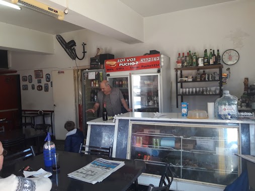
Sos Vos Pucho???
Luis Ángel Firpo, Córdoba
Bar
read more
411 m
Sos Vos Pucho???
Luis Ángel Firpo & Hernando Magallanes, Córdoba
Bar
read more
448 m
Barberis Antonio Omar
Luis Ángel Firpo & Hernando Magallanes, Córdoba
Bar
read more
466 m
Sala De Lujo Tojá!
2498 X5008EEH, Padre Grenon 2400, Córdoba
Bar
read more
518 m
Comadreja Resto Pub
Córdoba
Bar
read more
541 m
Barrio Zumaran
Granadero Díaz 3000-3098, Córdoba
Bar
read more
541 m
Barrio Sumaran
Granadero Díaz 3000-3098, Córdoba
Bar
read more
664 m
Bar Zingara
Bv. Los Granaderos 2456, Córdoba
Bar
read more
741 m
Restobar Boulevard
Bv Los Granaderos 2265, Córdoba
Bar
read more
774 m
TEQUILA. Vinos & Birras.
2208, Bv. Los Granaderos, Córdoba
Bar
read more
1.388 km
Matute Choripan Y Hamburguesas
Centenario 594, Córdoba
Bar
read more
1.402 km
Living Frog's
X5008IAV, Soldado Ruiz 2004, Córdoba
Bar
read more
1.41 km
F
Rozas de Oquendo, Córdoba
Bar
read more
1.434 km
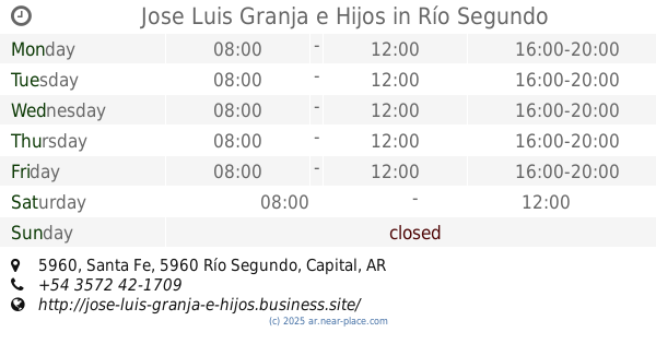
Jose Luis Granja e Hijos
Santa Fe 5960, Río Segundo
Bar
read more
1.774 km
Bonafide Patio
Córdoba
Bar
read more
1.782 km
Destino Gastronómico
Rodríguez del Busto 3875, Córdoba
Bar
read more
1.79 km
Café Espresso Perla Negra
Unquillo 644, Córdoba
Bar
read more
1.901 km
Tu
Rodríguez del Busto 3787, Córdoba
Bar
read more
2.035 km
MAMANÚ
Avenida Emilio Caraffa 2529, Córdoba
Bar
read more
2.067 km
La oficina
La Cordillera 3511, Córdoba
Bar
read more
2.119 km
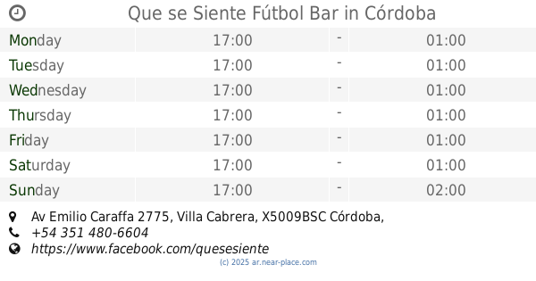
Que se Siente Fútbol Bar
Av Emilio Caraffa 2775, Villa Cabrera, Córdoba
Bar
read more
2.175 km
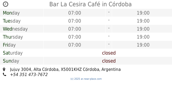
Bar La Cesira Café
Jujuy 3004, Alta Córdoba, Córdoba
Bar
read more
2.608 km
Vidón Bar
Mariano Fragueiro 2185, Córdoba
Bar
read more
📑
all categories
Accounting
Administrative area level 1
Administrative area level 2
Airport
Amusement park
Aquarium
Art gallery
Atm
Bakery
Bank
Bar
Beauty salon
Bicycle store
Book store
Bowling alley
Bus station
Cafe
Campground
Car dealer
Car rental
Car repair
Car wash
Casino
Cemetery
Church
City hall
Clothing store
Colloquial area
Convenience store
Country
Courthouse
Dentist
Department store
Doctor
Electrician
Electronics store
Embassy
Establishment
Finance
Fire station
Florist
Food
Funeral home
Furniture store
Gas station
General contractor
Grocery or supermarket
Gym
Hair care
Hardware store
Health
Hindu Temple
Home goods store
Hospital
Insurance agency
Intersection
Jewelry store
Laundry
Lawyer
Library
Light rail station
Liquor store
Local government office
Locality
Locksmith
Lodging
Meal delivery
Meal takeaway
Mosque
Movie rental
Movie theater
Moving company
Museum
Natural feature
Neighborhood
Night club
Painter
Park
Parking
Pet store
Pharmacy
Physiotherapist
Place of worship
Plumber
Point of interest
Police
Political
Post office
Premise
Real estate agency
Restaurant
Roofing contractor
Route
Rv park, camping
School
Shoe store
Shopping mall
Spa
Stadium
Storage
Store
Subpremise
Subway station
Supermarket
Synagogue
Taxi stand
Train station
Transit station
Travel agency
University
Veterinary care
Zoo
sublocality level 1
sublocality level 3
↑