Bar nearby Le Bar
Argentina
Bar nearby Le Bar
Le Bar
422, Tucumán, C1049, Comuna 1, Buenos Aires, AR Argentina
contacts phone
:
+54 52190858
website:
lebarbuenosaires.blogspot.com.ar
Latitude:
-34.6009077
, Longitude:
-58.3728988
larger map & directions
read more
nearest Bar
242 m
Tango
Avenida Presidente Roque Sáenz Peña 864
Bar
read more
363 m
Cutty Sark
Reconquista 873
Bar
read more
401 m
WINDOW'S
Florida 844
Bar
read more
464 m
Bar del Bajo
San Martín 940
Bar
read more
474 m
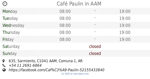
Café Paulin
Sarmiento 635, AAM
Cafe
Bar
Restaurant
Point of interest
Food
Establishment
read more
543 m
El Federal
San Martín 1015
Bar
read more
552 m
Tuo Tempo - Microccentro
C1041AAO 725, AAO, Sarmiento
Bar
read more
626 m
Persicco
C1038AAN, Presidente Teniente General Juan Domingo Perón 698
Bar
read more
638 m
Chubby
Suipacha 714
Bar
read more
664 m
Hotel 725 Continental
Avenida Presidente Roque Sáenz Peña 725
Bar
Lodging
Restaurant
Food
Point of interest
Establishment
read more
714 m
Arte & Gourmet
Marcelo Torcuato de Alvear 799
Bar
read more
801 m
Restaurante Catedral 33
AAQ, Avenida Rivadavia 548, Buenos Aires
Bar
read more
802 m
Cafecito
Sarmiento 951
Bar
read more
855 m
Bar Bidou
Bartolomé Mitre 838
Bar
read more
891 m
CYCLONE
Galería Pasaje Roverano, Avenida de Mayo 560
Bar
read more
934 m
Pedemonte
Avenida de Mayo 682 C1084AAB, Buenos Aires
Bar
read more
961 m
Elauge Hermanos
Avenida Hipólito Yrigoyen 640
Bar
read more
974 m
Bar Cosenza
Carlos Pellegrini 1083
Bar
read more
998 m
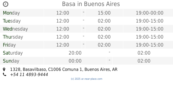
Basa
Basavilbaso 1328
Bar
read more
1.056 km
Cafiolo Cafe y Restaurante
Avenida Hipólito Yrigoyen 802
Bar
read more
1.06 km
Fiesta KIKI
C1010AAV, Cerrito 1058
Bar
read more
1.07 km
Bar Dark
C1084AAR, Avenida de Mayo 912
Bar
read more
1.107 km
Bar los Amigos
Galería Shoping Center, Libertad 282
Bar
read more
1.264 km
Matilda Class Fash Bar
C1033AAC, Avenida Rivadavia 1188
Bar
read more
1.325 km
Bar Norte
Juncal 1141
Bar
read more
📑
all categories
Accounting
Administrative area level 1
Administrative area level 2
Airport
Amusement park
Aquarium
Art gallery
Atm
Bakery
Bank
Bar
Beauty salon
Bicycle store
Book store
Bowling alley
Bus station
Cafe
Campground
Car dealer
Car rental
Car repair
Car wash
Casino
Cemetery
Church
City hall
Clothing store
Colloquial area
Convenience store
Country
Courthouse
Dentist
Department store
Doctor
Electrician
Electronics store
Embassy
Establishment
Finance
Fire station
Florist
Food
Funeral home
Furniture store
Gas station
General contractor
Grocery or supermarket
Gym
Hair care
Hardware store
Health
Hindu Temple
Home goods store
Hospital
Insurance agency
Intersection
Jewelry store
Laundry
Lawyer
Library
Light rail station
Liquor store
Local government office
Locality
Locksmith
Lodging
Meal delivery
Meal takeaway
Mosque
Movie rental
Movie theater
Moving company
Museum
Natural feature
Neighborhood
Night club
Painter
Park
Parking
Pet store
Pharmacy
Physiotherapist
Place of worship
Plumber
Point of interest
Police
Political
Post office
Premise
Real estate agency
Restaurant
Roofing contractor
Route
Rv park, camping
School
Shoe store
Shopping mall
Spa
Stadium
Storage
Store
Subpremise
Subway station
Supermarket
Synagogue
Taxi stand
Train station
Transit station
Travel agency
University
Veterinary care
Zoo
sublocality level 1
sublocality level 3
↑