Bar nearby Lobby Bar Imperio
Coronavirus disease (COVID-19) Situation
confirmed cases
10128845
deaths
130841
Argentina
Bar nearby Lobby Bar Imperio
Lobby Bar Imperio
181, Avenida Callao, C1022, Comuna 1, Buenos Aires, AR Argentina
contacts phone
:
+54
Latitude:
-34.6071416
, Longitude:
-58.39174
larger map & directions
read more
nearest Bar
93 m
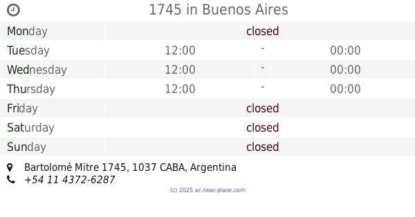
1745
Bartolomé Mitre 1745
Bar
read more
333 m
Bar del Anfiteatro Sa
Avenida Corrientes 1660
Bar
read more
367 m
Covo Birreria
ABH, Montevideo 382
Bar
read more
454 m
Pizzeria Kentucky
Avenida Corrientes 1502
Bar
read more
488 m
Café Paraná
Lavalle 1627
Bar
read more
533 m
La Herradura
Combate de los Pozos 215
Bar
read more
547 m
Mamakia
Lavalle 1530
Bar
read more
597 m
La Gauchada
Tucumán 1648
Bar
read more
624 m
Dante Bar
Tucumán 1617
Bar
read more
704 m
Darte el gusto
Viamonte 1782
Bar
read more
734 m
Parrilla ¨La Tranquera ¨
Talcahuano 462
Bar
read more
734 m
Faustino Pub
Sarmiento 1234
Bar
read more
742 m
Jose Evaristo Uriburu 501 SRL
Lavalle 2199
Bar
read more
795 m
Bar google
Viamonte 1519, piso 3, oficina 3
Bar
read more
805 m
BAR Sofía
Combate de los Pozos 443
Bar
read more
806 m
Matilda Class Fash Bar
C1033AAC, Avenida Rivadavia 1188
Bar
read more
845 m
Baez Calderón
Salta 125
Bar
read more
883 m
Restobar Fusas y Corcheas
Teniente General Juan Domingo Perón 2450
Bar
read more
889 m
Bar The Crack
Viamonte 1379
Bar
read more
988 m
Eclipse Drink
México 1558
Bar
read more
999 m
Don Cristóbal
Talcahuano 758
Bar
read more
1.046 km
Cerveza Patagonia - Refugio Paraguay
ABB, Paraguay 1448
Bar
read more
1.056 km
Cervecería Patagonia
Paraguay 1426
Bar
read more
1.253 km
El Fronteo Bar&Lounge
México 1158, C1097AAX
Bar
read more
1.256 km
Comedy Coffee
Larrea 750, Buenos Aires
Bar
read more
📑
all categories
Accounting
Administrative area level 1
Administrative area level 2
Airport
Amusement park
Aquarium
Art gallery
Atm
Bakery
Bank
Bar
Beauty salon
Bicycle store
Book store
Bowling alley
Bus station
Cafe
Campground
Car dealer
Car rental
Car repair
Car wash
Casino
Cemetery
Church
City hall
Clothing store
Colloquial area
Convenience store
Country
Courthouse
Dentist
Department store
Doctor
Electrician
Electronics store
Embassy
Establishment
Finance
Fire station
Florist
Food
Funeral home
Furniture store
Gas station
General contractor
Grocery or supermarket
Gym
Hair care
Hardware store
Health
Hindu Temple
Home goods store
Hospital
Insurance agency
Intersection
Jewelry store
Laundry
Lawyer
Library
Light rail station
Liquor store
Local government office
Locality
Locksmith
Lodging
Meal delivery
Meal takeaway
Mosque
Movie rental
Movie theater
Moving company
Museum
Natural feature
Neighborhood
Night club
Painter
Park
Parking
Pet store
Pharmacy
Physiotherapist
Place of worship
Plumber
Point of interest
Police
Political
Post office
Premise
Real estate agency
Restaurant
Roofing contractor
Route
Rv park, camping
School
Shoe store
Shopping mall
Spa
Stadium
Storage
Store
Subpremise
Subway station
Supermarket
Synagogue
Taxi stand
Train station
Transit station
Travel agency
University
Veterinary care
Zoo
sublocality level 1
sublocality level 3
↑