Bar nearby Pampa Bar
Argentina
Bar nearby Pampa Bar
Pampa Bar
887, La Pampa, Comuna 13, Buenos Aires, AR Argentina
contacts phone
:
+54
Latitude:
-34.5553333
, Longitude:
-58.4385781
larger map & directions
read more
nearest Bar
243 m
Biblos
Echeverría 802
Bar
read more
253 m
Livra Pizza Bar
La Pampa 693
Bar
read more
289 m
Sucre
Mariscal Antonio José de Sucre 676
Bar
read more
401 m
Figueroa Alcorta Y Pampa Trasporte Público
Avenida Presidente Figueroa Alcorta 6413-6433
Bar
read more
448 m
La puerta mágica, Bajo Belgrano
Mariscal Antonio José de Sucre 1238, C1428DUN
Bar
read more
483 m
Cervecería Artesanal
Avenida Ernesto Tornquist
Bar
read more
494 m
Agote Restó
Miñones 1720
Bar
read more
638 m
Estac
Mariscal Antonio José de Sucre 129 0-1302, C1428DUP
Bar
read more
684 m
Casa Babel Bistro
C1428DJG, Mendoza 1267
Bar
read more
718 m
bar Retto
Echeverría 1432
Bar
read more
766 m
Dogo Bar
Juramento 1924
Bar
read more
790 m
Roque golf
La Pampa 214
Bar
read more
846 m
Tango cocina
Mendoza 1432
Bar
read more
862 m
Mos
Avenida del Libertador 5390
Bar
read more
870 m
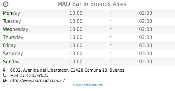
Mad
Avenida del Libertador 6002
Bar
read more
870 m
MAD Bar
Avenida del Libertador 6002
Bar
read more
885 m
Kafa & Deli
1631 C1426CPB, Federico Lacroze 1601
Bar
read more
889 m
Diabliyo Pub
Avenida Federico Lacroze 1648
Bar
read more
933 m
La Casa de Bacus
Zabala 1615
Bar
read more
938 m
Bayres Beer
Migueletes 1183, C1426BUO
Bar
read more
965 m
Lo de jazi
Zabala 1655
Bar
read more
992 m
Tequila Club
Avenida Costanera Rafael Obligado and, La Pampa
Bar
read more
1.039 km
Beluga Bar
Avenida Costanera Rafael Obligado 4899
Bar
read more
1.091 km
UB Beer
Zabala 1837
Bar
read more
1.247 km
Club 74
Av Pres. Figueroa Alcorta 7474
Bar
read more
📑
all categories
Accounting
Administrative area level 1
Administrative area level 2
Airport
Amusement park
Aquarium
Art gallery
Atm
Bakery
Bank
Bar
Beauty salon
Bicycle store
Book store
Bowling alley
Bus station
Cafe
Campground
Car dealer
Car rental
Car repair
Car wash
Casino
Cemetery
Church
City hall
Clothing store
Colloquial area
Convenience store
Country
Courthouse
Dentist
Department store
Doctor
Electrician
Electronics store
Embassy
Establishment
Finance
Fire station
Florist
Food
Funeral home
Furniture store
Gas station
General contractor
Grocery or supermarket
Gym
Hair care
Hardware store
Health
Hindu Temple
Home goods store
Hospital
Insurance agency
Intersection
Jewelry store
Laundry
Lawyer
Library
Light rail station
Liquor store
Local government office
Locality
Locksmith
Lodging
Meal delivery
Meal takeaway
Mosque
Movie rental
Movie theater
Moving company
Museum
Natural feature
Neighborhood
Night club
Painter
Park
Parking
Pet store
Pharmacy
Physiotherapist
Place of worship
Plumber
Point of interest
Police
Political
Post office
Premise
Real estate agency
Restaurant
Roofing contractor
Route
Rv park, camping
School
Shoe store
Shopping mall
Spa
Stadium
Storage
Store
Subpremise
Subway station
Supermarket
Synagogue
Taxi stand
Train station
Transit station
Travel agency
University
Veterinary care
Zoo
sublocality level 1
sublocality level 3
↑