Bar nearby PLAZA BEXARES
Argentina
Bar nearby PLAZA BEXARES
PLAZA BEXARES
4212, Avenida Cabildo, C1429, Comuna 12, Buenos Aires, AR Argentina
contacts phone
:
+54 11 4704-7322
website:
plaza-besares.negocio.site
Latitude:
-34.5451937
, Longitude:
-58.471376
larger map & directions
read more
nearest Bar
270 m
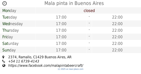
Mala pinta
Ramallo 2374
Bar
read more
310 m
Panza Llena Corazon Contento
3756, ACR, Ciudad de La Paz C1429ACR, Buenos Aires
Bar
read more
380 m
Tomago
Arias 2451
Bar
read more
380 m
Beer67
Arias 2451
Bar
read more
406 m
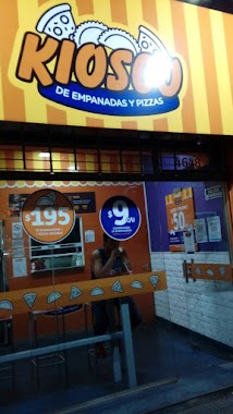
Kiosco De Empanadas Pizas
Avenida Cabildo 4648, C1429ADU
Bar
read more
422 m
reconquisata y cordoba
Avenida García del Río 2100, C1429DEN
Bar
read more
608 m
Esquina Taki Bar
Avenida García del Río 3003, Buenos Aires
Bar
read more
673 m
Bar La Playa
Vedia 2401-2409
Bar
read more
679 m
La Republiqueta de Acracia
O'Higgins 3574
Bar
read more
697 m
Brew House
C1429BBO, O'Higgins 3573
Bar
read more
699 m
Cervecería Bunker
C1429BBO, O'Higgins 3571
Bar
read more
713 m
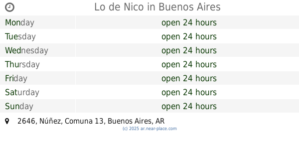
Lo de Nico
Núñez 2646
Bar
read more
771 m
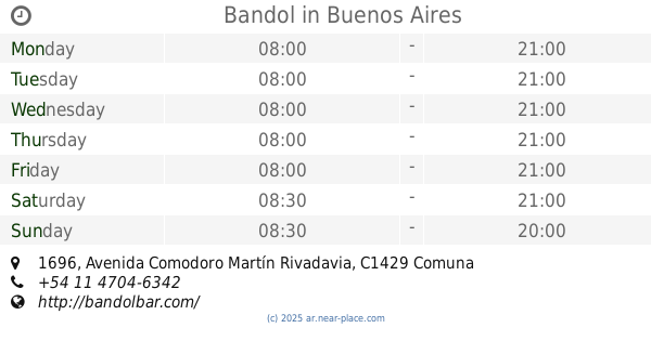
Bandol
Avenida Comodoro Martín Rivadavia 1696
Bar
read more
875 m
Estadio
Cuba 3282, Buenos Aires
Bar
read more
892 m
Kiosco
Avenida Cabildo 3378
Bar
read more
903 m
Otro Mundo Cervecería
Grecia 3394
Bar
read more
908 m
Cerveceria los Beltran
Jaramillo 3278, C1429CSB
Bar
read more
944 m
Cervecería Berlin
Cuba 3201, C1429AXI
Bar
read more
1.008 km
Mi Bar
Av. Maipu 88 local 6, Florida
Bar
read more
1.038 km
Cervecha
Manuela Pedraza 1810, C1429CBH
Bar
read more
1.074 km
Bar Los Andes
Avellaneda y vias FC Belgrano Norte Aristóbulo del Valle, Vicente López, Buenos Aires, Vicente López
Bar
read more
1.104 km
Parrilla Hoy Carne
Aristóbulo del Valle 1596, Florida
Bar
read more
1.125 km
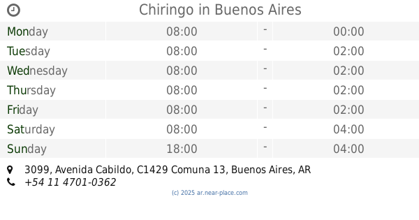
Chiringo
Avenida Cabildo 3099
Bar
read more
1.127 km
Holzen Hops
Iberá 2424
Bar
read more
1.249 km
Luzmala Bar
Arcos 2950
Bar
read more
📑
all categories
Accounting
Administrative area level 1
Administrative area level 2
Airport
Amusement park
Aquarium
Art gallery
Atm
Bakery
Bank
Bar
Beauty salon
Bicycle store
Book store
Bowling alley
Bus station
Cafe
Campground
Car dealer
Car rental
Car repair
Car wash
Casino
Cemetery
Church
City hall
Clothing store
Colloquial area
Convenience store
Country
Courthouse
Dentist
Department store
Doctor
Electrician
Electronics store
Embassy
Establishment
Finance
Fire station
Florist
Food
Funeral home
Furniture store
Gas station
General contractor
Grocery or supermarket
Gym
Hair care
Hardware store
Health
Hindu Temple
Home goods store
Hospital
Insurance agency
Intersection
Jewelry store
Laundry
Lawyer
Library
Light rail station
Liquor store
Local government office
Locality
Locksmith
Lodging
Meal delivery
Meal takeaway
Mosque
Movie rental
Movie theater
Moving company
Museum
Natural feature
Neighborhood
Night club
Painter
Park
Parking
Pet store
Pharmacy
Physiotherapist
Place of worship
Plumber
Point of interest
Police
Political
Post office
Premise
Real estate agency
Restaurant
Roofing contractor
Route
Rv park, camping
School
Shoe store
Shopping mall
Spa
Stadium
Storage
Store
Subpremise
Subway station
Supermarket
Synagogue
Taxi stand
Train station
Transit station
Travel agency
University
Veterinary care
Zoo
sublocality level 1
sublocality level 3
↑