Bar nearby Rincón Urkupiña
Argentina
Bar nearby Rincón Urkupiña
Rincón Urkupiña
2954, Carlos Berg, C1437, Comuna 4, Buenos Aires, AR Argentyna
contacts phone
:
+54
Latitude:
-34.6500774
, Longitude:
-58.4326268
larger map & directions
read more
nearest Bar
215 m
Bar Al Paso Marcelito
Avenida General Francisco Fernández de la Cruz
Bar
read more
663 m
Bon Appetit (Solo Delivery De 12 A 16)
Avenida Perito Moreno C1437BSA
Bar
read more
665 m
Snak Bar La Peruana
C1437BSG, Avenida Perito Moreno 1917
Bar
read more
778 m
Los 4 Hermanos
Avenida Rivera Indarte
Bar
read more
870 m
Lo de Pepe
C1437DAB, Las Palmas 2406
Bar
read more
907 m
Kalamora
Crespo 2011
Bar
read more
997 m
LA CASONA de Bajo Flores
Calle 1
Bar
read more
1.021 km
Moly's
La Capital
Bar
read more
1.05 km
Casa Franchini
Tilcara 2190
Bar
read more
1.1 km
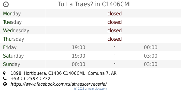
Tu La Traes?
Hortiguera 1898, C1406CML
Bar
read more
1.128 km
Grill 66 Bar Restaurante
Argentina
Bar
read more
1.244 km
Restaurante Mailin
Avenida Chiclana 4202
Bar
read more
1.273 km
Salteñas El Conejo
Corea 1768
Bar
read more
1.426 km
Mechita
Avenida La Plata 2906
Bar
read more
1.519 km
Balbastro
Balbastro
Bar
read more
1.546 km
Los Cristales
Grito de Asencio 3884
Bar
read more
1.56 km
La Blanqueada
Avenida Sáenz 1201
Bar
read more
1.777 km
Vinoteca Sabores
Avenida Asamblea 653
Bar
read more
2.052 km
Marcos
Avenida Almafuerte 300-226, C1437JLP
Bar
read more
2.061 km
MI SOL
Avenida Chiclana 3700
Bar
read more
2.176 km
Cliza Resto Bar
Avenida General Francisco Fernández de la Cruz 3624, Villa Soldati
Bar
read more
2.221 km
DON ALFDREDO PARRILLA
Avenida Almafuerte 89
Bar
read more
2.403 km
Boedo a la parrilla
Avenida Boedo 1656
Bar
read more
2.457 km
Beer Pub BierWelt
Avenida Boedo 1600
Bar
read more
2.474 km
Bierwelt - Cervecería Artesanal
Boedo 1600 (esquina Inclán)
Bar
read more
📑
all categories
Accounting
Administrative area level 1
Administrative area level 2
Airport
Amusement park
Aquarium
Art gallery
Atm
Bakery
Bank
Bar
Beauty salon
Bicycle store
Book store
Bowling alley
Bus station
Cafe
Campground
Car dealer
Car rental
Car repair
Car wash
Casino
Cemetery
Church
City hall
Clothing store
Colloquial area
Convenience store
Country
Courthouse
Dentist
Department store
Doctor
Electrician
Electronics store
Embassy
Establishment
Finance
Fire station
Florist
Food
Funeral home
Furniture store
Gas station
General contractor
Grocery or supermarket
Gym
Hair care
Hardware store
Health
Hindu Temple
Home goods store
Hospital
Insurance agency
Intersection
Jewelry store
Laundry
Lawyer
Library
Light rail station
Liquor store
Local government office
Locality
Locksmith
Lodging
Meal delivery
Meal takeaway
Mosque
Movie rental
Movie theater
Moving company
Museum
Natural feature
Neighborhood
Night club
Painter
Park
Parking
Pet store
Pharmacy
Physiotherapist
Place of worship
Plumber
Point of interest
Police
Political
Post office
Premise
Real estate agency
Restaurant
Roofing contractor
Route
Rv park, camping
School
Shoe store
Shopping mall
Spa
Stadium
Storage
Store
Subpremise
Subway station
Supermarket
Synagogue
Taxi stand
Train station
Transit station
Travel agency
University
Veterinary care
Zoo
sublocality level 1
sublocality level 3
↑