Cafe nearby Alegre En Flor
Coronavirus disease (COVID-19) Situation
confirmed cases
10128845
deaths
130841
Argentina
Cafe nearby Alegre En Flor
Alegre En Flor
501, Felipe Vallese, C1405, Comuna 6, Buenos Aires, AR Argentyna
contacts phone
:
+54 11 4982-7351
Latitude:
-34.611299
, Longitude:
-58.4410156
larger map & directions
read more
nearest Cafe
269 m
Coffee shop
Avenida Díaz Vélez 5298
Cafe
read more
440 m
La Tolva
Avenida Acoyte 393
Cafe
read more
546 m
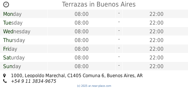
Terrazas
Leopoldo Marechal 1000
Cafe
read more
579 m
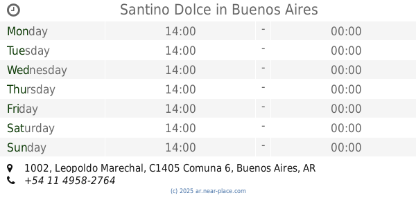
Santino Dolce
Leopoldo Marechal 1002
Cafe
read more
609 m
Subway / Chocorisimo Ice Cream & Coffee
Avenida Acoyte 200
Cafe
read more
836 m
Cafe Fausto
Avenida Warnes 96
Cafe
read more
849 m
Starbucks
Avenida Rivadavia 5071, C1424CEF
Cafe
read more
874 m
Havanna
Avenida Rivadavia 4987
Cafe
read more
877 m
Vittoriano Café
Coronel Apolinario Figueroa 300
Cafe
read more
892 m
El Coleccionista
Av Rivadavia 4929
Cafe
read more
957 m
Carrusel
Avenida Rivadavia 5108, C1424CET
Cafe
read more
962 m
Josefina
Otamendi 67
Cafe
read more
982 m
Confitería El Greco
Rivadavia 5353
Cafe
Bakery
Store
Restaurant
Food
Point of interest
Establishment
read more
993 m
Confiteria PLAZA
C1424BLB, Doblas 14
Cafe
read more
995 m
Plaza Cafe Caballito
Av. Rivadavia &, Doblas C1424
Cafe
read more
1.009 km
Plaza Café
Avenida Rivadavia 4732
Cafe
read more
1.029 km
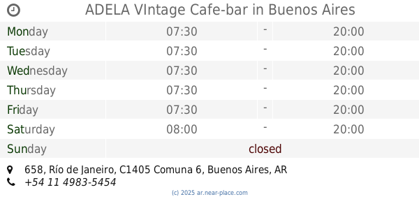
ADELA VIntage Cafe-bar
Río de Janeiro 658
Cafe
read more
1.043 km
Emporio del Sandwich
Neuquén 1238
Cafe
read more
1.051 km
Matteo Café Deli Market
Avenida José María Moreno 124
Cafe
read more
1.056 km
Tienda De Café
Rosario 400
Cafe
read more
1.098 km
Eventos liza
C1414CEE, Avenida Doctor Honorio Pueyrredón 1515
Cafe
read more
1.168 km
Río Café Bar
Sarmiento 4699
Cafe
read more
1.171 km
Otero Café
Guayaquil 389, Buenos Aires, Ciudad Autónoma de Buenos Aires
Cafe
read more
1.222 km
Mil Seiscientos
Rojas 1600
Cafe
read more
1.308 km
Orión Café
Guayaquil 202
Cafe
read more
📑
all categories
Accounting
Administrative area level 1
Administrative area level 2
Airport
Amusement park
Aquarium
Art gallery
Atm
Bakery
Bank
Bar
Beauty salon
Bicycle store
Book store
Bowling alley
Bus station
Cafe
Campground
Car dealer
Car rental
Car repair
Car wash
Casino
Cemetery
Church
City hall
Clothing store
Colloquial area
Convenience store
Country
Courthouse
Dentist
Department store
Doctor
Electrician
Electronics store
Embassy
Establishment
Finance
Fire station
Florist
Food
Funeral home
Furniture store
Gas station
General contractor
Grocery or supermarket
Gym
Hair care
Hardware store
Health
Hindu Temple
Home goods store
Hospital
Insurance agency
Intersection
Jewelry store
Laundry
Lawyer
Library
Light rail station
Liquor store
Local government office
Locality
Locksmith
Lodging
Meal delivery
Meal takeaway
Mosque
Movie rental
Movie theater
Moving company
Museum
Natural feature
Neighborhood
Night club
Painter
Park
Parking
Pet store
Pharmacy
Physiotherapist
Place of worship
Plumber
Point of interest
Police
Political
Post office
Premise
Real estate agency
Restaurant
Roofing contractor
Route
Rv park, camping
School
Shoe store
Shopping mall
Spa
Stadium
Storage
Store
Subpremise
Subway station
Supermarket
Synagogue
Taxi stand
Train station
Transit station
Travel agency
University
Veterinary care
Zoo
sublocality level 1
sublocality level 3
↑