Cafe nearby Babel Café
Coronavirus disease (COVID-19) Situation
confirmed cases
10128845
deaths
130841
Argentina
Cafe nearby Babel Café
Babel Café
2216, Avenida Corrientes, 1046, Comuna 3, Buenos Aires, AR Argentina
contacts phone
:
+54 11 4951-5755
website:
m.facebook.com
Latitude:
-34.604724
, Longitude:
-58.398611
larger map & directions
read more
nearest Cafe
217 m
Enol - Pizza & Cafe
Avenida Corrientes 2414
Cafe
read more
310 m
Metalfer
Sarmiento 2441
Cafe
read more
403 m
Angélica
Azcuénaga 153
Cafe
read more
447 m
Havanna
Riobamba 401, C1025ABI
Cafe
read more
487 m
Cafetería de Ciencias Económicas
Balvanera
Cafe
read more
543 m
Olimpo Café Bar
Pasteur 791
Cafe
read more
595 m
Havanna
Av Córdoba 2370
Cafe
read more
608 m
Bonafide
Avenida Pueyrredón 529
Cafe
read more
609 m
Café Estero
Viamonte 2602
Cafe
read more
646 m
Bonafide
Avenida Rivadavia 2496
Cafe
read more
661 m
Espacio Cafe - Bar
Hipólito Yrigoyen, Buenos Aires 2355 ( entre Matheu y, Pichincha, C1089AAS
Cafe
read more
699 m
Starbucks
Av Corrientes 1702
Cafe
read more
709 m
Faricci Heladeria Av Pueyrredon
Avenida Pueyrredón 802
Cafe
read more
713 m
Cafe Door's
Tucumán 1702
Cafe
read more
724 m
Bar Camila
Rodríguez Peña 331
Cafe
read more
726 m
Angelica
Riobamba 815
Cafe
read more
755 m
Josefina Pizza y Café
Avenida Córdoba 2550
Cafe
read more
823 m
Havanna
Avenida Pueyrredón 140
Cafe
read more
846 m
Carrá
Lavalle 1609
Cafe
read more
858 m
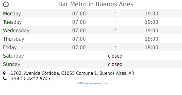
Bar Metro
Avenida Córdoba 1702
Cafe
read more
877 m
La Picoña
Viamonte 1645
Cafe
read more
932 m
Edición Limitada
Lavalle 1546
Cafe
read more
1.016 km
Café Martínez
Avenida Pueyrredón 1202
Cafe
read more
1.041 km
Candy
Paraná 116
Cafe
read more
1.084 km
Fariccí
Avenida Entre Ríos 301
Cafe
read more
📑
all categories
Accounting
Administrative area level 1
Administrative area level 2
Airport
Amusement park
Aquarium
Art gallery
Atm
Bakery
Bank
Bar
Beauty salon
Bicycle store
Book store
Bowling alley
Bus station
Cafe
Campground
Car dealer
Car rental
Car repair
Car wash
Casino
Cemetery
Church
City hall
Clothing store
Colloquial area
Convenience store
Country
Courthouse
Dentist
Department store
Doctor
Electrician
Electronics store
Embassy
Establishment
Finance
Fire station
Florist
Food
Funeral home
Furniture store
Gas station
General contractor
Grocery or supermarket
Gym
Hair care
Hardware store
Health
Hindu Temple
Home goods store
Hospital
Insurance agency
Intersection
Jewelry store
Laundry
Lawyer
Library
Light rail station
Liquor store
Local government office
Locality
Locksmith
Lodging
Meal delivery
Meal takeaway
Mosque
Movie rental
Movie theater
Moving company
Museum
Natural feature
Neighborhood
Night club
Painter
Park
Parking
Pet store
Pharmacy
Physiotherapist
Place of worship
Plumber
Point of interest
Police
Political
Post office
Premise
Real estate agency
Restaurant
Roofing contractor
Route
Rv park, camping
School
Shoe store
Shopping mall
Spa
Stadium
Storage
Store
Subpremise
Subway station
Supermarket
Synagogue
Taxi stand
Train station
Transit station
Travel agency
University
Veterinary care
Zoo
sublocality level 1
sublocality level 3
↑