Cafe nearby Café 5 Hispanos
Argentina
Cafe nearby Café 5 Hispanos
Café 5 Hispanos
1402, Pavón, C1151, Comuna 1, Buenos Aires, AR Argentina
contacts phone
:
+54
Latitude:
-34.6261906
, Longitude:
-58.3858532
larger map & directions
read more
nearest Cafe
315 m
Central Cafe
Avenida Juan de Garay 1180
Cafe
read more
322 m
pasteleria rodrigo
Cochabamba 1302, C1150AAX
Cafe
read more
365 m
Don Benjamín Restó Bar Café
Avenida Juan de Garay 1702
Cafe
read more
467 m
Havanna
Lima 1732
Cafe
read more
488 m
Snack Bar 24 hs.
Avenida Entre Ríos 1605
Cafe
read more
513 m
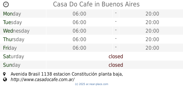
Casa Do Cafe
Avenida Brasil 1138 estacion Constitución planta baja
Cafe
read more
601 m
Vivaldi Libros Bar
Santiago del Estero 1098
Cafe
read more
627 m
Astor Café
Bernardo de Irigoyen 1312
Cafe
read more
726 m
CAFÉ DEL BIOGRAFO
Avenida San Juan 1900
Cafe
read more
822 m
Cafe Martinez
Avenida Entre Ríos 1002
Cafe
read more
872 m
CAFE & BAR Lo De PePe
Tacuarí 1101
Cafe
read more
909 m
Heladería Peppino
Tacuarí 1099
Cafe
read more
918 m
Havanna
C1280AEA, Perdriel 25
Cafe
read more
956 m
Max
Avenida San Juan 2101
Cafe
read more
957 m
Casa e
Avenida Independencia 1565
Cafe
read more
970 m
L'Amore De Sant
C1102AAR, Carlos Calvo 900
Cafe
read more
1000 m
Musel
Bernardo de Irigoyen 910
Cafe
read more
1.048 km
La Cueva
Avenida San Juan 2230
Cafe
read more
1.067 km
PerTe Parque Patricios
C1260AAF, Avenida Brasil 2301
Cafe
read more
1.116 km
La Moderna
Humberto 1º 699
Cafe
read more
1.136 km
Bar Catulo
Pichincha 1895
Cafe
read more
1.212 km
La Flor Más Dulce
Piedras 828
Cafe
read more
1.232 km
Café la Peruana Sa
Chacabuco 915
Cafe
read more
1.25 km
Кафе Bar Piedras
C1070AAO, Piedras 781
Cafe
read more
1.269 km
Zumo
Avenida Independencia 797
Cafe
read more
📑
all categories
Accounting
Administrative area level 1
Administrative area level 2
Airport
Amusement park
Aquarium
Art gallery
Atm
Bakery
Bank
Bar
Beauty salon
Bicycle store
Book store
Bowling alley
Bus station
Cafe
Campground
Car dealer
Car rental
Car repair
Car wash
Casino
Cemetery
Church
City hall
Clothing store
Colloquial area
Convenience store
Country
Courthouse
Dentist
Department store
Doctor
Electrician
Electronics store
Embassy
Establishment
Finance
Fire station
Florist
Food
Funeral home
Furniture store
Gas station
General contractor
Grocery or supermarket
Gym
Hair care
Hardware store
Health
Hindu Temple
Home goods store
Hospital
Insurance agency
Intersection
Jewelry store
Laundry
Lawyer
Library
Light rail station
Liquor store
Local government office
Locality
Locksmith
Lodging
Meal delivery
Meal takeaway
Mosque
Movie rental
Movie theater
Moving company
Museum
Natural feature
Neighborhood
Night club
Painter
Park
Parking
Pet store
Pharmacy
Physiotherapist
Place of worship
Plumber
Point of interest
Police
Political
Post office
Premise
Real estate agency
Restaurant
Roofing contractor
Route
Rv park, camping
School
Shoe store
Shopping mall
Spa
Stadium
Storage
Store
Subpremise
Subway station
Supermarket
Synagogue
Taxi stand
Train station
Transit station
Travel agency
University
Veterinary care
Zoo
sublocality level 1
sublocality level 3
↑