Cafe nearby COSI
Coronavirus disease (COVID-19) Situation
confirmed cases
10128845
deaths
130841
Argentina
Cafe nearby COSI
COSI
542, Bolívar, C1066, Comuna 1, Buenos Aires, AR Argentina
contacts phone
:
+54 11 4331-3527
website:
www.cosisantelmo.com
Latitude:
-34.6141495
, Longitude:
-58.3731594
larger map & directions
read more
nearest Cafe
163 m
El Caribe Cafe - Bar
Defensa 419
Cafe
read more
237 m
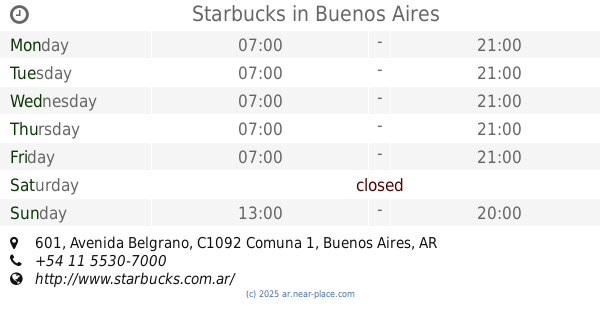
Starbucks
Avenida Belgrano 601
Cafe
read more
239 m
Café El Tucumano
México 679
Cafe
read more
276 m
Frank Haus
353, AAG, Perú, Buenos Aires
Cafe
read more
455 m
Paseo de Las Luces
Avenida Presidente Julio A. Roca 598
Cafe
read more
497 m
Terrazas - Cafe
Defensa 899
Cafe
read more
506 m
Starbucks
Adolfo Alsina 300, Buenos Aires
Cafe
read more
627 m
Alice's Tea House
Carlos Calvo 372
Cafe
read more
632 m
Calypso San Telmo
Carlos Calvo 618
Cafe
read more
650 m
Cavas de Calipso
Bernardo de Irigoyen 458
Cafe
read more
651 m
Havanna
Avenida de Mayo 615
Cafe
read more
661 m
Alimentari
Moreno 945
Cafe
read more
725 m
Harmony
Avenida de Mayo 798
Cafe
read more
766 m
Café Tortoni
Avenida de Mayo 825
Cafe
read more
832 m
Cafe Martinez
Lima 701
Cafe
read more
847 m
Havanna monserrat
Lima 281, AAE
Cafe
read more
849 m
Havanna Lima
Lima 281, C1073AAE
Cafe
read more
860 m
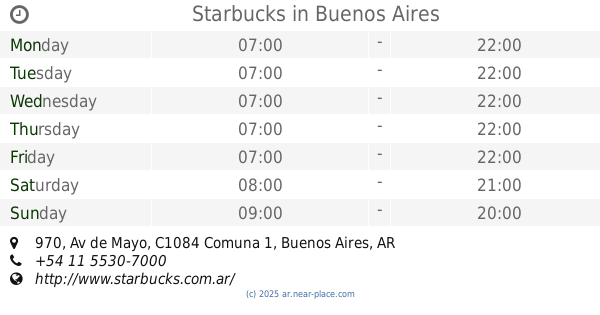
Starbucks
Av de Mayo 970
Cafe
read more
869 m
Coffee Machine
Esmeralda 81, C1035ABA
Cafe
read more
918 m
Ascone Jorge H.
Salta 489
Cafe
read more
922 m
Malvina Pastelería y Cafetería
Moreno 1167
Cafe
read more
927 m
Starbucks Torre Galicia
Presidente Teniente General Juan Domingo Perón 430, Buenos Aires
Cafe
read more
932 m
Café Balcarce
Avenida Presidente Roque Sáenz Peña 728, Buenos Aires
Cafe
read more
1.015 km
Auditorio Cafe
Avenida Hipólito Yrigoyen 1174
Cafe
read more
1.065 km
Posta Café
Avenida Presidente Roque Sáenz Peña 805
Cafe
read more
📑
all categories
Accounting
Administrative area level 1
Administrative area level 2
Airport
Amusement park
Aquarium
Art gallery
Atm
Bakery
Bank
Bar
Beauty salon
Bicycle store
Book store
Bowling alley
Bus station
Cafe
Campground
Car dealer
Car rental
Car repair
Car wash
Casino
Cemetery
Church
City hall
Clothing store
Colloquial area
Convenience store
Country
Courthouse
Dentist
Department store
Doctor
Electrician
Electronics store
Embassy
Establishment
Finance
Fire station
Florist
Food
Funeral home
Furniture store
Gas station
General contractor
Grocery or supermarket
Gym
Hair care
Hardware store
Health
Hindu Temple
Home goods store
Hospital
Insurance agency
Intersection
Jewelry store
Laundry
Lawyer
Library
Light rail station
Liquor store
Local government office
Locality
Locksmith
Lodging
Meal delivery
Meal takeaway
Mosque
Movie rental
Movie theater
Moving company
Museum
Natural feature
Neighborhood
Night club
Painter
Park
Parking
Pet store
Pharmacy
Physiotherapist
Place of worship
Plumber
Point of interest
Police
Political
Post office
Premise
Real estate agency
Restaurant
Roofing contractor
Route
Rv park, camping
School
Shoe store
Shopping mall
Spa
Stadium
Storage
Store
Subpremise
Subway station
Supermarket
Synagogue
Taxi stand
Train station
Transit station
Travel agency
University
Veterinary care
Zoo
sublocality level 1
sublocality level 3
↑