Cafe nearby Dia
Coronavirus disease (COVID-19) Situation
confirmed cases
10128845
deaths
130841
Argentina
Cafe nearby Dia
Dia
4501-4579, Juan Francisco Seguí, Comuna 14, Buenos Aires, AR Argentina
contacts phone
:
+54
Latitude:
-34.5737605
, Longitude:
-58.4206274
larger map & directions
read more
nearest Cafe
115 m
Maxikiosco Oro
Fray Justo Santa María de Oro 2933, Buenos Aires
Cafe
read more
157 m
Café Martínez
Avenida del Libertador 3598
Cafe
read more
251 m
Nucha
Avenida Cerviño 4403
Cafe
read more
350 m
Gourmet Service SRL
Cafe
read more
434 m
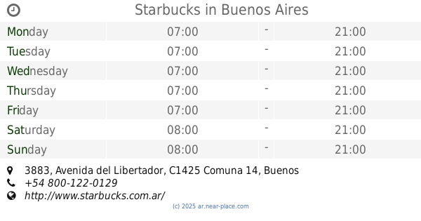
Starbucks
Avenida del Libertador 3883
Cafe
read more
437 m
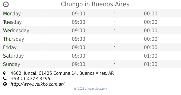
Chungo
Juncal 4602
Cafe
read more
455 m
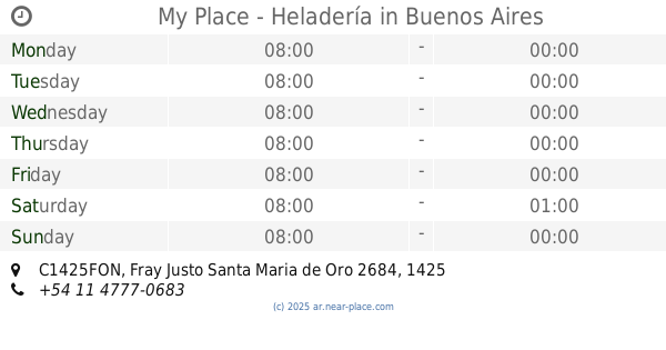
My Place - Heladería
C1425FON, Fray Justo Santa Maria de Oro 2684
Cafe
read more
518 m
The Coffee Store Charcas
Cafe
read more
792 m
Cafe Martinez
Avenida Santa Fe 4298, C.A.B.A
Cafe
read more
814 m
Enricco Helados Y Café
Avenida Santa Fe 4250
Cafe
read more
862 m
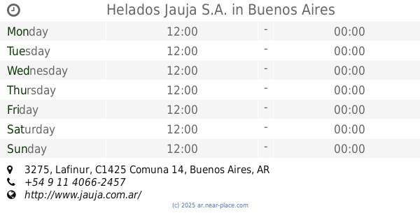
Helados Jauja S.A.
Lafinur 3275
Cafe
read more
957 m
Starbucks
Godoy Cruz 2560
Cafe
read more
985 m
Coco Café
C1425APP, Cabello 3794, Buenos Aires
Cafe
read more
1.006 km
Del viento
República Arabe Siria 3037
Cafe
read more
1.051 km
Piccolo Caffe
Arce 399, C1426BSC
Cafe
read more
1.059 km
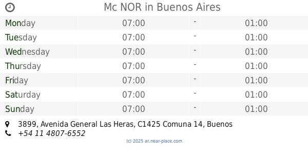
Mc NOR
Avenida General Las Heras 3899
Cafe
read more
1.095 km
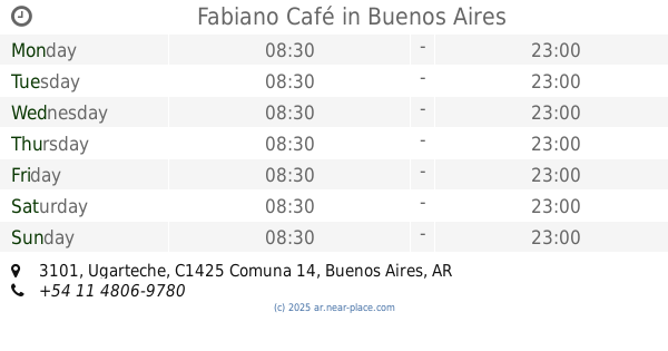
Fabiano Café
Ugarteche 3101
Cafe
read more
1.145 km
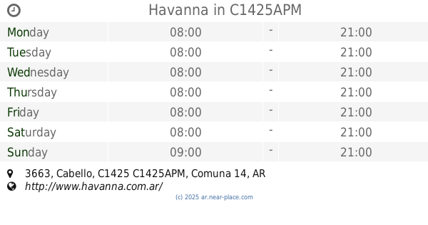
Havanna
Cabello 3663, C1425APM
Cafe
read more
1.163 km
Havanna
Cabello 3700-3602, C1425APN
Cafe
read more
1.168 km
Via Vecchia
Avenida General Las Heras 3800
Cafe
read more
1.19 km
Café Martínez
Avenida Cerviño 3602
Cafe
read more
1.205 km
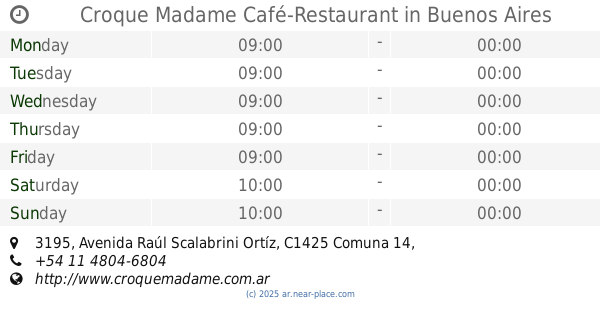
Croque Madame Café-Restaurant
Avenida Raúl Scalabrini Ortíz 3195
Cafe
read more
1.216 km
Havanna
Raúl Scalabrini Ortíz 3101-3199, C1425DBM
Cafe
read more
1.238 km
Sugar & Spice
Guatemala 5415, Buenos Aires
Cafe
read more
1.301 km
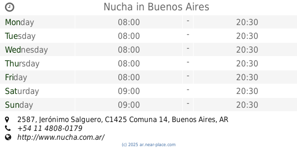
Nucha
Jerónimo Salguero 2587
Cafe
read more
📑
all categories
Accounting
Administrative area level 1
Administrative area level 2
Airport
Amusement park
Aquarium
Art gallery
Atm
Bakery
Bank
Bar
Beauty salon
Bicycle store
Book store
Bowling alley
Bus station
Cafe
Campground
Car dealer
Car rental
Car repair
Car wash
Casino
Cemetery
Church
City hall
Clothing store
Colloquial area
Convenience store
Country
Courthouse
Dentist
Department store
Doctor
Electrician
Electronics store
Embassy
Establishment
Finance
Fire station
Florist
Food
Funeral home
Furniture store
Gas station
General contractor
Grocery or supermarket
Gym
Hair care
Hardware store
Health
Hindu Temple
Home goods store
Hospital
Insurance agency
Intersection
Jewelry store
Laundry
Lawyer
Library
Light rail station
Liquor store
Local government office
Locality
Locksmith
Lodging
Meal delivery
Meal takeaway
Mosque
Movie rental
Movie theater
Moving company
Museum
Natural feature
Neighborhood
Night club
Painter
Park
Parking
Pet store
Pharmacy
Physiotherapist
Place of worship
Plumber
Point of interest
Police
Political
Post office
Premise
Real estate agency
Restaurant
Roofing contractor
Route
Rv park, camping
School
Shoe store
Shopping mall
Spa
Stadium
Storage
Store
Subpremise
Subway station
Supermarket
Synagogue
Taxi stand
Train station
Transit station
Travel agency
University
Veterinary care
Zoo
sublocality level 1
sublocality level 3
↑