Cafe nearby Méli Mélo
Coronavirus disease (COVID-19) Situation
confirmed cases
10128845
deaths
130841
Argentina
Cafe nearby Méli Mélo
Méli Mélo
5990, Avenida del Libertador, C1428, Comuna 13, Buenos Aires, AR Argentina
contacts phone
:
+54 11 4788-3926
website:
melimelo.com.ar
Latitude:
-34.5568806
, Longitude:
-58.4477395
larger map & directions
read more
nearest Cafe
225 m
Churrería Herrera
Juramento 1698
Cafe
read more
260 m
El Café de la Esquina
Avenida del Libertador
Cafe
read more
271 m
Milo Coffee & Deli
C1428DGS, Olazábal 1458
Cafe
read more
291 m
Starbucks
Avenida del Libertador 6220
Cafe
read more
291 m
Starbucks
Av. Del Libertador 6200
Cafe
read more
292 m
Amo mi Matcha
Mendoza 1702
Cafe
read more
304 m
Café Martínez
Olazábal 1700-1602, C1428DGU
Cafe
read more
517 m
Cônte Café
C1426ENA, José Hernández 1395
Cafe
read more
548 m
Crème Chic - Helados -
3 de Febrero 2296
Cafe
read more
576 m
Quiero Café
Avenida Monroe 1720
Cafe
read more
580 m
delicity
O'Higgins 2100-2002, C1428AGF
Cafe
read more
681 m
Chungo Helados, Café y Delicatessen
buenos Aires Esquina, Franklin D. Roosevelt
Cafe
read more
848 m
Almacén de Pizzas
Avenida del Libertador 6700
Cafe
read more
859 m
Crisol Núñez
1602, Avenida Congreso
Cafe
read more
896 m
Havanna UB
Zabala 1851
Cafe
read more
905 m
Tea Connection
Vuelta de Obligado
Cafe
read more
1.019 km
Hay Café Café
Quesada 1515
Cafe
read more
1.02 km
Starbucks
C1428AAP, Avenida Cabildo 2020
Cafe
read more
1.024 km
Starbucks
Avenida Cabildo 2020
Cafe
read more
1.024 km
Goiabada
3 de Febrero 2823
Cafe
read more
1.123 km
Havanna
Echeverría 2501
Cafe
read more
1.138 km
Caffe Nascosto
Ciudad de La Paz 1883
Cafe
read more
1.142 km
Good Coffe
Ciudad de La Paz 1898
Cafe
read more
1.164 km
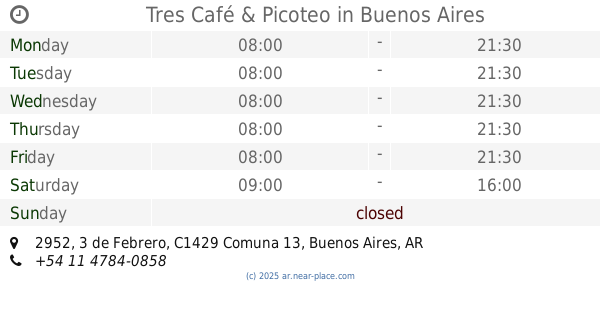
Tres Café & Picoteo
C1429BFD, 3 de Febrero 2952
Cafe
read more
1.192 km
PIT DELI
Soldado de la Independencia 1154
Cafe
read more
📑
all categories
Accounting
Administrative area level 1
Administrative area level 2
Airport
Amusement park
Aquarium
Art gallery
Atm
Bakery
Bank
Bar
Beauty salon
Bicycle store
Book store
Bowling alley
Bus station
Cafe
Campground
Car dealer
Car rental
Car repair
Car wash
Casino
Cemetery
Church
City hall
Clothing store
Colloquial area
Convenience store
Country
Courthouse
Dentist
Department store
Doctor
Electrician
Electronics store
Embassy
Establishment
Finance
Fire station
Florist
Food
Funeral home
Furniture store
Gas station
General contractor
Grocery or supermarket
Gym
Hair care
Hardware store
Health
Hindu Temple
Home goods store
Hospital
Insurance agency
Intersection
Jewelry store
Laundry
Lawyer
Library
Light rail station
Liquor store
Local government office
Locality
Locksmith
Lodging
Meal delivery
Meal takeaway
Mosque
Movie rental
Movie theater
Moving company
Museum
Natural feature
Neighborhood
Night club
Painter
Park
Parking
Pet store
Pharmacy
Physiotherapist
Place of worship
Plumber
Point of interest
Police
Political
Post office
Premise
Real estate agency
Restaurant
Roofing contractor
Route
Rv park, camping
School
Shoe store
Shopping mall
Spa
Stadium
Storage
Store
Subpremise
Subway station
Supermarket
Synagogue
Taxi stand
Train station
Transit station
Travel agency
University
Veterinary care
Zoo
sublocality level 1
sublocality level 3
↑