Cafe nearby Panaderia La Pochocha
Coronavirus disease (COVID-19) Situation
confirmed cases
10128845
deaths
130841
Argentina
Cafe nearby Panaderia La Pochocha
Panaderia La Pochocha
Moreno, Comuna 3, Buenos Aires, AR Argentinien
contacts phone
:
+54 237 468-0790
Latitude:
-34.6128327
, Longitude:
-58.3931927
larger map & directions
read more
nearest Cafe
126 m
Fariccí
Avenida Entre Ríos 301
Cafe
read more
300 m
Café Victoria
Avenida Entre Ríos 102-118
Cafe
read more
494 m
Tío Ángel
México 1599
Cafe
read more
636 m
Espacio Cafe - Bar
Hipólito Yrigoyen, Buenos Aires 2355 ( entre Matheu y, Pichincha, C1089AAS
Cafe
read more
664 m
La Moncloa
Avenida de Mayo 1500
Cafe
read more
709 m
Casa e
Avenida Independencia 1565
Cafe
read more
715 m
Las Medialunas del Abuelo
San José 91
Cafe
read more
767 m
La Lucila
San José 18
Cafe
read more
784 m
Café París
Santiago del Estero 224
Cafe
read more
785 m
Candy
Paraná 116
Cafe
read more
837 m
Bonafide
Avenida Rivadavia 2496
Cafe
read more
850 m
Angélica
Azcuénaga 153
Cafe
read more
880 m
Bar Camila
Rodríguez Peña 331
Cafe
read more
929 m
Bar Mayo
Chile 1300
Cafe
read more
931 m
Ascone Jorge H.
Salta 489
Cafe
read more
949 m
Starbucks
Av Corrientes 1702
Cafe
read more
949 m
Malvina Pastelería y Cafetería
Moreno 1167
Cafe
read more
959 m
Havanna
Riobamba 401, C1025ABI
Cafe
read more
982 m
Bar El Vato
Av. Corrientes 1700-1612, C1042AAP, Buenos Aires
Cafe
read more
998 m
Auditorio Cafe
Avenida Hipólito Yrigoyen 1174
Cafe
read more
1.023 km
La Clac
Avenida de Mayo 1156
Cafe
read more
1.06 km
Metalfer
Sarmiento 2441
Cafe
read more
1.136 km
Enol - Pizza & Cafe
Avenida Corrientes 2414
Cafe
read more
1.261 km
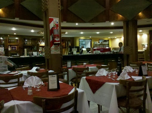
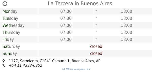
La Tercera
Sarmiento 1177
Cafe
read more
1.347 km
Starbucks
Cerrito 330
Cafe
read more
📑
all categories
Accounting
Administrative area level 1
Administrative area level 2
Airport
Amusement park
Aquarium
Art gallery
Atm
Bakery
Bank
Bar
Beauty salon
Bicycle store
Book store
Bowling alley
Bus station
Cafe
Campground
Car dealer
Car rental
Car repair
Car wash
Casino
Cemetery
Church
City hall
Clothing store
Colloquial area
Convenience store
Country
Courthouse
Dentist
Department store
Doctor
Electrician
Electronics store
Embassy
Establishment
Finance
Fire station
Florist
Food
Funeral home
Furniture store
Gas station
General contractor
Grocery or supermarket
Gym
Hair care
Hardware store
Health
Hindu Temple
Home goods store
Hospital
Insurance agency
Intersection
Jewelry store
Laundry
Lawyer
Library
Light rail station
Liquor store
Local government office
Locality
Locksmith
Lodging
Meal delivery
Meal takeaway
Mosque
Movie rental
Movie theater
Moving company
Museum
Natural feature
Neighborhood
Night club
Painter
Park
Parking
Pet store
Pharmacy
Physiotherapist
Place of worship
Plumber
Point of interest
Police
Political
Post office
Premise
Real estate agency
Restaurant
Roofing contractor
Route
Rv park, camping
School
Shoe store
Shopping mall
Spa
Stadium
Storage
Store
Subpremise
Subway station
Supermarket
Synagogue
Taxi stand
Train station
Transit station
Travel agency
University
Veterinary care
Zoo
sublocality level 1
sublocality level 3
↑