Convenience store nearby Kiosco Casa Matías
Coronavirus disease (COVID-19) Situation
confirmed cases
10128845
deaths
130841
Argentina
Convenience store nearby Kiosco Casa Matías
Kiosco Casa Matías
602, Conde, C1426, Comuna 13, Buenos Aires, AR Argentina
contacts phone
:
+54
Latitude:
-34.578412
, Longitude:
-58.448634
larger map & directions
read more
nearest Convenience store
110 m
Frutería Milcam
Avenida Federico Lacroze 3167
Convenience store
read more
218 m
Maxikiosco Conde
Conde 808
Convenience store
read more
319 m
Luzbrig
Conde 906
Convenience store
read more
401 m
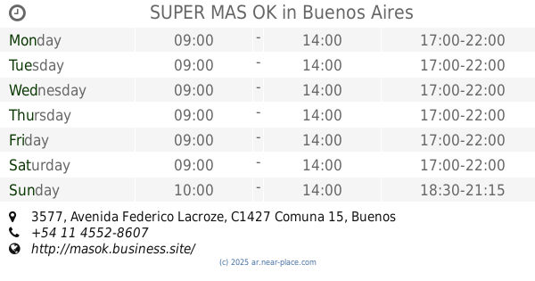
SUPER MAS OK
Avenida Federico Lacroze 3577
Convenience store
read more
436 m
Kiosko Lacroze
Avenida Federico Lacroze 2883
Convenience store
read more
455 m
Kiosko Palpa
Palpa 2973
Convenience store
read more
475 m
Lin Xiufang
Delgado 876
Convenience store
read more
534 m
Kiosco López
Avenida Federico Lacroze 2817
Convenience store
read more
563 m
El Kiosko de Ricardo
Teodoro García 2810
Convenience store
read more
600 m
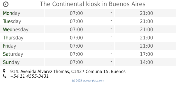
The Continental kiosk
Avenida Álvarez Thomas 914
Convenience store
read more
705 m
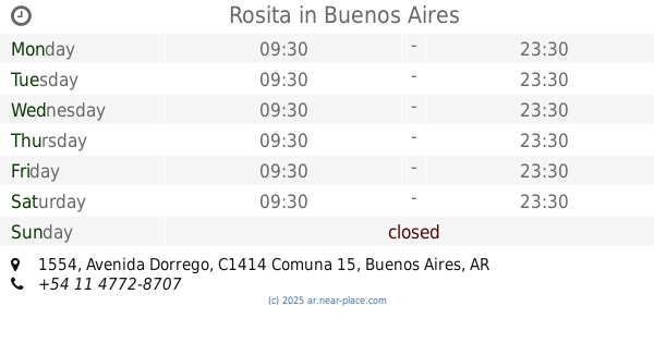
Rosita
Avenida Dorrego 1554
Convenience store
read more
725 m
Kiosco Marta
Avenida Coronel Niceto Vega 6020
Convenience store
read more
737 m
Maritel
Santos Dumont 2712
Convenience store
read more
771 m
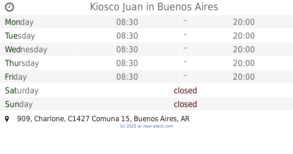
Kiosco Juan
Charlone 909
Convenience store
read more
796 m
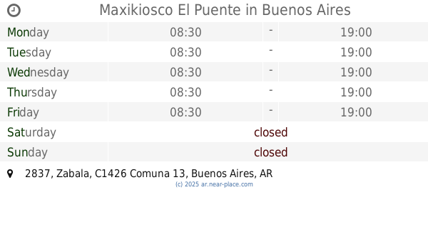
Maxikiosco El Puente
Zabala 2837
Convenience store
read more
821 m
Maxikiosco Ichiban
Avenida Federico Lacroze 2492
Convenience store
read more
854 m
Minimercado Trong
Avenida Coronel Niceto Vega 5913
Convenience store
read more
866 m
Pago Fácil
Avenida Forest 730
Convenience store
read more
866 m
Laudino
Avenida Forest 730
Convenience store
read more
904 m
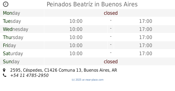
Peinados Beatríz
Céspedes 2595
Convenience store
read more
928 m
Kiosco Los Muchachos
Avenida Álvarez Thomas 1218
Convenience store
read more
933 m
Sanabria Miguel Ángel
Aguilar 2474
Convenience store
read more
984 m
Coto
Teodoro García 2419
Convenience store
read more
1.121 km
Maxikiosco Palazzo
Gorriti 5712
Convenience store
read more
1.143 km
Tucu Tucu
Bonpland 1509
Convenience store
read more
📑
all categories
Accounting
Administrative area level 1
Administrative area level 2
Airport
Amusement park
Aquarium
Art gallery
Atm
Bakery
Bank
Bar
Beauty salon
Bicycle store
Book store
Bowling alley
Bus station
Cafe
Campground
Car dealer
Car rental
Car repair
Car wash
Casino
Cemetery
Church
City hall
Clothing store
Colloquial area
Convenience store
Country
Courthouse
Dentist
Department store
Doctor
Electrician
Electronics store
Embassy
Establishment
Finance
Fire station
Florist
Food
Funeral home
Furniture store
Gas station
General contractor
Grocery or supermarket
Gym
Hair care
Hardware store
Health
Hindu Temple
Home goods store
Hospital
Insurance agency
Intersection
Jewelry store
Laundry
Lawyer
Library
Light rail station
Liquor store
Local government office
Locality
Locksmith
Lodging
Meal delivery
Meal takeaway
Mosque
Movie rental
Movie theater
Moving company
Museum
Natural feature
Neighborhood
Night club
Painter
Park
Parking
Pet store
Pharmacy
Physiotherapist
Place of worship
Plumber
Point of interest
Police
Political
Post office
Premise
Real estate agency
Restaurant
Roofing contractor
Route
Rv park, camping
School
Shoe store
Shopping mall
Spa
Stadium
Storage
Store
Subpremise
Subway station
Supermarket
Synagogue
Taxi stand
Train station
Transit station
Travel agency
University
Veterinary care
Zoo
sublocality level 1
sublocality level 3
↑