Convenience store nearby KIOSCO MAX
Coronavirus disease (COVID-19) Situation
confirmed cases
10128845
deaths
130841
Argentina
Convenience store nearby KIOSCO MAX
KIOSCO MAX
2150, Armenia, C1425, Comuna 14, Buenos Aires, AR Argentina
contacts phone
:
+54
Latitude:
-34.586502
, Longitude:
-58.423288
larger map & directions
read more
nearest Convenience store
301 m
Prendes
DBA, Avenida Raúl Scalabrini Ortíz 1995
Convenience store
read more
428 m
Santa Sabina
Gurruchaga 1767
Convenience store
read more
456 m
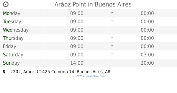
Aráoz Point
Aráoz 2202
Convenience store
read more
477 m
Palermo Vicio
Jorge Luis Borges 2423
Convenience store
read more
510 m
MaxiKiosko
Thames 2424
Convenience store
read more
546 m
Kioscopolis
Jorge Luis Borges 2488
Convenience store
read more
550 m
Nane
Thames 2471
Convenience store
read more
559 m
Kiosco Plaza Italia
Avenida Santa Fe 4104
Convenience store
read more
580 m
Carlotto Juan Domingo
Thames 2495
Convenience store
read more
602 m
Mono Loco
Charcas 3698
Convenience store
read more
638 m
OPEN 25 HS!
Avenida Santa Fe 4292
Convenience store
read more
687 m
Luiggi
Darregueyra 2469
Convenience store
read more
779 m
Enlace
Avenida Raúl Scalabrini Ortíz 1372
Convenience store
read more
797 m
El Bonsai
Gorriti 4399
Convenience store
read more
845 m
Lin Wei
Godoy Cruz 2675
Convenience store
read more
858 m
Drugstore
Paraguay 5050
Convenience store
read more
906 m
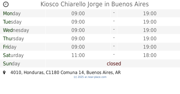
Kiosco Chiarello Jorge
Honduras 4010
Convenience store
read more
962 m
Nazar Anchorena
Juncal 3596
Convenience store
read more
978 m
La Francisca Feria de Campo
Avenida Coronel Niceto Vega 4712
Convenience store
read more
1.056 km
MAXIKIOSCO TODO A PULMÓN
Fitz Roy 2260
Convenience store
read more
1.126 km
Martin G Jimenez
Paraguay 3419
Convenience store
read more
1.138 km
Kiosko Elisa y Anibal
Honduras 3711
Convenience store
read more
1.184 km
Lupa
Bonpland 2315
Convenience store
read more
1.201 km
Maxikiosco Marabunta
Avenida Raúl Scalabrini Ortíz 1034
Convenience store
read more
1.24 km
Wang Min Hui
Billinghurst 1348
Convenience store
read more
📑
all categories
Accounting
Administrative area level 1
Administrative area level 2
Airport
Amusement park
Aquarium
Art gallery
Atm
Bakery
Bank
Bar
Beauty salon
Bicycle store
Book store
Bowling alley
Bus station
Cafe
Campground
Car dealer
Car rental
Car repair
Car wash
Casino
Cemetery
Church
City hall
Clothing store
Colloquial area
Convenience store
Country
Courthouse
Dentist
Department store
Doctor
Electrician
Electronics store
Embassy
Establishment
Finance
Fire station
Florist
Food
Funeral home
Furniture store
Gas station
General contractor
Grocery or supermarket
Gym
Hair care
Hardware store
Health
Hindu Temple
Home goods store
Hospital
Insurance agency
Intersection
Jewelry store
Laundry
Lawyer
Library
Light rail station
Liquor store
Local government office
Locality
Locksmith
Lodging
Meal delivery
Meal takeaway
Mosque
Movie rental
Movie theater
Moving company
Museum
Natural feature
Neighborhood
Night club
Painter
Park
Parking
Pet store
Pharmacy
Physiotherapist
Place of worship
Plumber
Point of interest
Police
Political
Post office
Premise
Real estate agency
Restaurant
Roofing contractor
Route
Rv park, camping
School
Shoe store
Shopping mall
Spa
Stadium
Storage
Store
Subpremise
Subway station
Supermarket
Synagogue
Taxi stand
Train station
Transit station
Travel agency
University
Veterinary care
Zoo
sublocality level 1
sublocality level 3
↑