Convenience store nearby KIOSCÓN The Best
Coronavirus disease (COVID-19) Situation
confirmed cases
10128845
deaths
130841
Argentina
Convenience store nearby KIOSCÓN The Best
KIOSCÓN The Best
6438, Avenida del Libertador, C1428, Comuna 13, Buenos Aires, AR Argentina
contacts phone
:
+54
Latitude:
-34.5526739
, Longitude:
-58.451348
larger map & directions
read more
nearest Convenience store
107 m
JORGE
Montañeses 2509
Convenience store
read more
312 m
Enoc Drug Store
Olazábal 1425
Convenience store
read more
364 m
Kiosco Marta
Arribeños 2768
Convenience store
read more
428 m
Blue tree
Arribeños 2830
Convenience store
read more
500 m
Maxikiosco JR
Mendoza 1291
Convenience store
read more
548 m
HOUSE of LUCK
Arribeños 2156
Convenience store
read more
556 m
Regalería Ruyi
Arribeños 2145
Convenience store
read more
560 m
ANA ACCESORIOS
Arribeños 2148
Convenience store
read more
572 m
KIOSCO MAXI
O'Higgins 2595
Convenience store
read more
574 m
Haag María
Juramento 1590
Convenience store
read more
576 m
Minimercado Chez Zorba
Juramento 1412
Convenience store
read more
615 m
MAXIKIOSCOS smile
Juramento 1696
Convenience store
read more
694 m
Maxikiosco
Echeverría 1442
Convenience store
read more
706 m
Carrefour Express
Echeverría 1420
Convenience store
read more
770 m
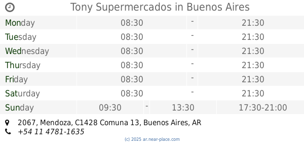
Tony Supermercados
Mendoza 2067
Convenience store
read more
784 m
VIRGILIO RAFFINETTI
Mendoza 2091
Convenience store
read more
961 m
Kunt's
Manuela Pedraza 1800
Convenience store
read more
961 m
Kurt's drugstore
Manuela Pedraza 1800
Convenience store
read more
985 m
OPEN 25 HS!
Avenida Cabildo 2501
Convenience store
read more
1.029 km
Kiosco Excalibur ll
Avenida Congreso 2374
Convenience store
read more
1.042 km
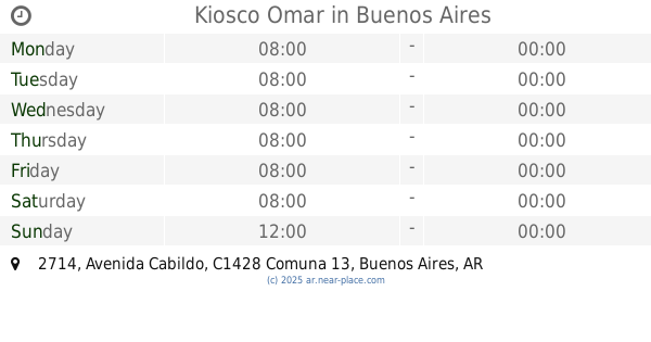
Kiosco Omar
Avenida Cabildo 2714
Convenience store
read more
1.174 km
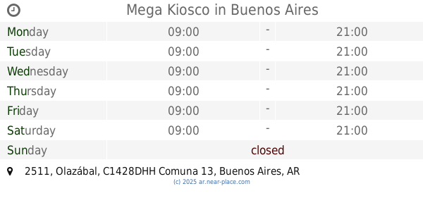
Mega Kiosco
Avenida Olazábal 2511
Convenience store
read more
1.174 km
Mega Kiosco
Olazábal 2511
Convenience store
read more
1.202 km
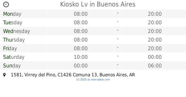
Kiosko Lv
Virrey del Pino 1581
Convenience store
read more
1.217 km
KIOSKO CELESTE
Amenábar 2417
Convenience store
read more
📑
all categories
Accounting
Administrative area level 1
Administrative area level 2
Airport
Amusement park
Aquarium
Art gallery
Atm
Bakery
Bank
Bar
Beauty salon
Bicycle store
Book store
Bowling alley
Bus station
Cafe
Campground
Car dealer
Car rental
Car repair
Car wash
Casino
Cemetery
Church
City hall
Clothing store
Colloquial area
Convenience store
Country
Courthouse
Dentist
Department store
Doctor
Electrician
Electronics store
Embassy
Establishment
Finance
Fire station
Florist
Food
Funeral home
Furniture store
Gas station
General contractor
Grocery or supermarket
Gym
Hair care
Hardware store
Health
Hindu Temple
Home goods store
Hospital
Insurance agency
Intersection
Jewelry store
Laundry
Lawyer
Library
Light rail station
Liquor store
Local government office
Locality
Locksmith
Lodging
Meal delivery
Meal takeaway
Mosque
Movie rental
Movie theater
Moving company
Museum
Natural feature
Neighborhood
Night club
Painter
Park
Parking
Pet store
Pharmacy
Physiotherapist
Place of worship
Plumber
Point of interest
Police
Political
Post office
Premise
Real estate agency
Restaurant
Roofing contractor
Route
Rv park, camping
School
Shoe store
Shopping mall
Spa
Stadium
Storage
Store
Subpremise
Subway station
Supermarket
Synagogue
Taxi stand
Train station
Transit station
Travel agency
University
Veterinary care
Zoo
sublocality level 1
sublocality level 3
↑