Convenience store nearby Siku de Francisco Pagano
Argentina
Convenience store nearby Siku de Francisco Pagano
Siku de Francisco Pagano
Buenos Aires, Argentina
contacts phone
:
+54 11 4854-3696
Latitude:
-34.603653
, Longitude:
-58.4463348
larger map & directions
read more
nearest Convenience store
537 m
Kiosco Loco
Padilla 681
Convenience store
read more
611 m
FIAMBRERIA Patry-Marty
Rojas 1813
Convenience store
read more
658 m
Maxikiosco
Padilla 921
Convenience store
read more
661 m
Kiosco Quevedo
Ferrari 202
Convenience store
read more
682 m
ESQUIDULCE
Acevedo 302
Convenience store
read more
748 m
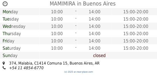
MAMIMIRA
Malabia 374
Convenience store
read more
770 m
SUN AND MOON
Malabia 386
Convenience store
read more
792 m
Simplicity
Avenida Raúl Scalabrini Ortíz 293
Convenience store
read more
830 m
Serrano Almacén
Serrano 462
Convenience store
read more
842 m
KIOSCO 58
Avenida Corrientes 5558
Convenience store
read more
850 m
Kiosco La Pato
Sunchales 557
Convenience store
read more
856 m
Despensa Kiosco
Sunchales 628
Convenience store
read more
890 m
Supermercado La Buena Suerte
Avenida Acoyte 758
Convenience store
read more
936 m
Al Sultan
Avenida Raúl Scalabrini Ortíz 399
Convenience store
read more
984 m
Maxiquisco Lindaura
Felipe Vallese 689
Convenience store
read more
988 m
Maxikiosco
Hidalgo 704
Convenience store
read more
996 m
Almacen Oscar
Cucha Cucha 2040
Convenience store
read more
1.015 km
Maxikiosco Los Duendes
Avenida Doctor Honorio Pueyrredón 691
Convenience store
read more
1.018 km
Maxikiosco y Libreria vera900
Vera 898
Convenience store
read more
1.074 km
Maxikiosco Locutorio Dano
Malabia 612
Convenience store
read more
1.077 km
Kiosco Díaz
Juan Ramirez de Velasco 471
Convenience store
read more
1.077 km
Kiosco Díaz
Juan Ramirez de Velazco 471
Convenience store
read more
1.091 km
La Familia
Atanasio Girardot 99
Convenience store
read more
1.125 km
Graffitti
General Manuel A. Rodríguez 2519
Convenience store
read more
1.269 km
Kiosco Malabia
Malabia 785
Convenience store
read more
📑
all categories
Accounting
Administrative area level 1
Administrative area level 2
Airport
Amusement park
Aquarium
Art gallery
Atm
Bakery
Bank
Bar
Beauty salon
Bicycle store
Book store
Bowling alley
Bus station
Cafe
Campground
Car dealer
Car rental
Car repair
Car wash
Casino
Cemetery
Church
City hall
Clothing store
Colloquial area
Convenience store
Country
Courthouse
Dentist
Department store
Doctor
Electrician
Electronics store
Embassy
Establishment
Finance
Fire station
Florist
Food
Funeral home
Furniture store
Gas station
General contractor
Grocery or supermarket
Gym
Hair care
Hardware store
Health
Hindu Temple
Home goods store
Hospital
Insurance agency
Intersection
Jewelry store
Laundry
Lawyer
Library
Light rail station
Liquor store
Local government office
Locality
Locksmith
Lodging
Meal delivery
Meal takeaway
Mosque
Movie rental
Movie theater
Moving company
Museum
Natural feature
Neighborhood
Night club
Painter
Park
Parking
Pet store
Pharmacy
Physiotherapist
Place of worship
Plumber
Point of interest
Police
Political
Post office
Premise
Real estate agency
Restaurant
Roofing contractor
Route
Rv park, camping
School
Shoe store
Shopping mall
Spa
Stadium
Storage
Store
Subpremise
Subway station
Supermarket
Synagogue
Taxi stand
Train station
Transit station
Travel agency
University
Veterinary care
Zoo
sublocality level 1
sublocality level 3
↑