Establishment nearby Credicop La Blaquotao
Coronavirus disease (COVID-19) Situation
confirmed cases
10128845
deaths
130841
Argentina
Establishment nearby Credicop La Blaquotao
Credicop La Blaquotao
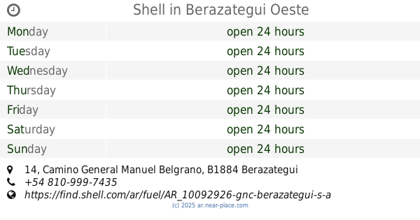
1418, Camino General Manuel Belgrano, B1884, Berazategui Oeste, Berazategui, AR Argentina
contacts phone
:
+54
Latitude:
-34.7855692
, Longitude:
-58.2529128
larger map & directions
read more
nearest Establishment
39 m
Shell
Avenida 14 14, Berazategui Oeste
Gas station
Atm
Convenience store
Finance
Food
Store
Point of interest
Establishment
read more
44 m
Shell
Avenida 14, Camino General Manuel Belgrano 14, Berazategui Oeste
Gas station
Atm
Convenience store
Finance
Store
Food
Point of interest
Establishment
read more
62 m
CENTRO DE ATENCION CREDICOOP
Avenida 14 469, Berazategui
Bank
Point of interest
Finance
Establishment
read more
176 m
Departamento 3 Ambientes
Camino General Manuel Belgrano 1570, Berazategui
Lodging
Point of interest
Establishment
read more
335 m
AVICOLA BERAZATEGUI
Ruta Provincial 36 1364, Berazategui
Restaurant
Food
Point of interest
Establishment
read more
367 m
Marcos Gabriel Piedrabuena
Remedios de Escalada, Florencio Varela
Lodging
Point of interest
Establishment
read more
514 m
Cop
Bombero Voluntario V. Senzabello 2226, Florencio Varela
Hospital
Health
Point of interest
Establishment
read more
736 m
El Amanecer (Restaurant - Bodegón)
B1884MIS, Camino General Manuel Belgrano 2006, Berazategui Oeste
Restaurant
Food
Point of interest
Establishment
read more
738 m
BURGER EMPIRE
14 E/ 110 y 111, Berazategui
Meal delivery
Cafe
Store
Restaurant
Food
Point of interest
Establishment
read more
758 m
Odontologia Pasquini
Pilar 2070, GQJ
Dentist
Point of interest
Health
Establishment
read more
835 m
Casa Mario
Avenida 7 122, Berazategui Oeste
Lodging
Point of interest
Establishment
read more
843 m
Lavaautos Senzabello Snack Bar
Bombero Voluntario V. Senzabello 1865, GHK
Cafe
Food
Point of interest
Establishment
read more
943 m
El Cruce
Sánchez de Loria 2251, Florencio Varela
Hospital
Health
Point of interest
Establishment
read more
1.022 km
Panaderia confiteria Demilu
HZD, Calle 114 1478, Berazategui Oeste
Cafe
Food
Point of interest
Establishment
read more
1.037 km
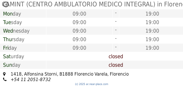
CAMINT (CENTRO AMBULATORIO MEDICO INTEGRAL)
Alfonsina Storni 1418, Florencio Varela
Hospital
Health
Point of interest
Establishment
read more
1.07 km
Odontosud Cruce Varela
Camino Gral. Manuel Belgrano 6485, B1888BJC, B1888BJC, Florencio Varela
Dentist
Health
Point of interest
Establishment
read more
1.091 km
Carrefour Express
Camino General Manuel Belgrano 6498, Florencio Varela
Supermarket
Convenience store
Grocery or supermarket
Food
Store
Point of interest
Establishment
read more
1.127 km
Cajero Automático Banco Provincia
Avenida Calchaquí 6599, Florencio Varela
Bank
Finance
Point of interest
Establishment
read more
1.204 km
Altos de mina
31°42'03. 65°02'05., Calle 5 5, Berazategui Oeste
Lodging
Point of interest
Establishment
read more
1.359 km
Odontologo Dentista
FPB, B1888FPB, Avenida Hipólito Yrigoyen 1702-1800, Florencio Varela
Dentist
Health
Point of interest
Establishment
read more
1.794 km
Panaderia La Reina.
Avenida Dardo Rocha 767 1884, Berazategui
Cafe
Food
Point of interest
Establishment
read more
1.96 km
SYEDENT ODONTOLOGIA
Calle 28 1355, Berazategui Oeste
Dentist
Point of interest
Health
Establishment
read more
2.082 km
SUPERMERCADO Tony y Raquel
José Manuel de Estrada 473, FXI
Supermarket
Grocery or supermarket
Store
Food
Point of interest
Establishment
read more
2.164 km
Facultad Lore
Félix Lope de Vega, Remedios de Escalada y, Florencio Varela
Hospital
Health
Point of interest
Establishment
read more
2.818 km
Beto Burgers
Bernardo de Monteagudo 2686, Florencio Varela
Restaurant
Point of interest
Food
Establishment
read more
📑
all categories
Accounting
Administrative area level 1
Administrative area level 2
Airport
Amusement park
Aquarium
Art gallery
Atm
Bakery
Bank
Bar
Beauty salon
Bicycle store
Book store
Bowling alley
Bus station
Cafe
Campground
Car dealer
Car rental
Car repair
Car wash
Casino
Cemetery
Church
City hall
Clothing store
Colloquial area
Convenience store
Country
Courthouse
Dentist
Department store
Doctor
Electrician
Electronics store
Embassy
Establishment
Finance
Fire station
Florist
Food
Funeral home
Furniture store
Gas station
General contractor
Grocery or supermarket
Gym
Hair care
Hardware store
Health
Hindu Temple
Home goods store
Hospital
Insurance agency
Intersection
Jewelry store
Laundry
Lawyer
Library
Light rail station
Liquor store
Local government office
Locality
Locksmith
Lodging
Meal delivery
Meal takeaway
Mosque
Movie rental
Movie theater
Moving company
Museum
Natural feature
Neighborhood
Night club
Painter
Park
Parking
Pet store
Pharmacy
Physiotherapist
Place of worship
Plumber
Point of interest
Police
Political
Post office
Premise
Real estate agency
Restaurant
Roofing contractor
Route
Rv park, camping
School
Shoe store
Shopping mall
Spa
Stadium
Storage
Store
Subpremise
Subway station
Supermarket
Synagogue
Taxi stand
Train station
Transit station
Travel agency
University
Veterinary care
Zoo
sublocality level 1
sublocality level 3
↑