Food nearby AMISTAD
Argentina
Food nearby AMISTAD
AMISTAD
3237, Avenida San Juan, C1233, Comuna 3, Buenos Aires, AR Argentina
contacts phone
:
+54
Latitude:
-34.6247163
, Longitude:
-58.4111284
larger map & directions
read more
nearest Food
189 m
Sushi Fun
Food
read more
284 m
VISA
Victoria Ocampo 360
Food
read more
355 m
Pamichuli 2
Estados Unidos 3205
Food
read more
387 m
PESCADERÍA Querandí
Humberto 1º 3001
Food
read more
388 m
El Nuevo Gricel
La Rioja 1184, ACN
Restaurant
Food
Point of interest
Establishment
read more
602 m
Mármara Recepciones
Avenida Boedo
Food
read more
655 m
Ollas Essen Aldana Ramos
Avenida San Juan 3756, Buenos Aires
Food
read more
701 m
Nelson Luis Fanzini E Hijos
Catamarca 1229
Food
read more
726 m
Frigorífico El Norteño
Avenida Boedo 602
Food
read more
736 m
JUCASA
Agrelo 3318
Food
read more
745 m
BEODO MIGA
México 3608
Food
read more
775 m
DELICATERING
Avenida Boedo 576
Food
read more
786 m
Nicolo Catering
Cochabamba 2655
Food
read more
875 m
CHILDREN'S PARTIES MATUTE
Agrelo 3607
Food
read more
885 m
Café Guidi
Avenida Jujuy 1407
Food
read more
899 m
PORTAL INCAICO
General Urquiza 508
Food
read more
910 m
Agromaria S.R.L
Carlos Calvo 3930
Food
read more
914 m
Estación Boedo Sport
Avenida Boedo 475
Food
read more
922 m
Pizza lo+hot
Avenida Boedo 432
Food
read more
928 m
La Union
Saavedra 1177
Food
read more
930 m
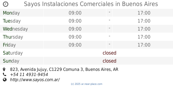
Sayos Instalaciones Comerciales
Avenida Jujuy 823
Food
read more
964 m
Frigorifi La Flor Carnes
Salcedo 2906
Food
read more
1.058 km
ÑUKE MAPU
Pavón 3972
Food
read more
1.075 km
Frigorífico El Rey
Avenida Juan de Garay 3900
Food
read more
1.124 km
PlayBack Sound & Lighting
Avenida Brasil 2946
Food
read more
📑
all categories
Accounting
Administrative area level 1
Administrative area level 2
Airport
Amusement park
Aquarium
Art gallery
Atm
Bakery
Bank
Bar
Beauty salon
Bicycle store
Book store
Bowling alley
Bus station
Cafe
Campground
Car dealer
Car rental
Car repair
Car wash
Casino
Cemetery
Church
City hall
Clothing store
Colloquial area
Convenience store
Country
Courthouse
Dentist
Department store
Doctor
Electrician
Electronics store
Embassy
Establishment
Finance
Fire station
Florist
Food
Funeral home
Furniture store
Gas station
General contractor
Grocery or supermarket
Gym
Hair care
Hardware store
Health
Hindu Temple
Home goods store
Hospital
Insurance agency
Intersection
Jewelry store
Laundry
Lawyer
Library
Light rail station
Liquor store
Local government office
Locality
Locksmith
Lodging
Meal delivery
Meal takeaway
Mosque
Movie rental
Movie theater
Moving company
Museum
Natural feature
Neighborhood
Night club
Painter
Park
Parking
Pet store
Pharmacy
Physiotherapist
Place of worship
Plumber
Point of interest
Police
Political
Post office
Premise
Real estate agency
Restaurant
Roofing contractor
Route
Rv park, camping
School
Shoe store
Shopping mall
Spa
Stadium
Storage
Store
Subpremise
Subway station
Supermarket
Synagogue
Taxi stand
Train station
Transit station
Travel agency
University
Veterinary care
Zoo
sublocality level 1
sublocality level 3
↑