Food nearby Los Recuerdos
Argentina
Food nearby Los Recuerdos
Los Recuerdos
325, San Lorenzo, C1064, Comuna 1, Buenos Aires, AR Argentina
contacts phone
:
+54
Latitude:
-34.616526
, Longitude:
-58.370684
larger map & directions
read more
nearest Food
58 m
Mora
Chile 318
Food
read more
182 m
Luma Algo de Morfi
Avenida Independencia 457
Food
read more
189 m
OH! MY FOOD
Avenida Paseo Colón 770
Food
read more
223 m
Chez Praliné
En los alrededores de San Telmo, Buenos Aires
Food
read more
236 m
La Catedral del Jugo
C1101AAJ, Estados Unidos 402-406
Food
read more
309 m
Ministerio de Agroindustria de la Nación
Avenida Paseo Colón 982
Food
read more
354 m
Jugos y Licuados
C1066AAT, Bolívar 970
Food
read more
402 m
Frigorífico Gorina
Perú 619
Food
read more
445 m
San Telmo - Viandas Y Catering
México 640
Food
read more
457 m
Cerveza Patagonia - Refugio Don Anselmo
Don Anselmo Aieta 1083
Food
read more
468 m
SENASA
Carlos Calvo 66
Food
read more
488 m
Pure Shrimp S.A.
Bolívar 1084 4,C1066AAV
Food
read more
497 m
Aguirre Maquinarias
Bolívar 401, Bolívar
Food
read more
529 m
Panaderia la Higienica Servicio de Catering - Lunch
Balcarce 348
Food
read more
578 m
El Remanso
Estados Unidos 745
Food
read more
634 m
Relax III
Moreno 493
Food
read more
643 m
Picante Buenos Aires
Chacabuco 1080, #2
Food
read more
719 m
La Puerto Rico
Adolfo Alsina 416
Restaurant
Bar
Bakery
Store
Food
Point of interest
Establishment
read more
727 m
Dulce Desayuarte
Cochabamba 429
Food
read more
748 m
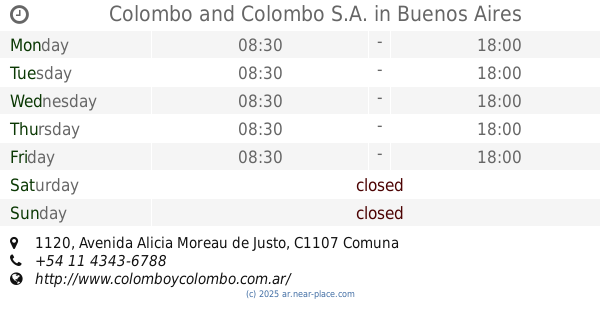
Colombo and Colombo S.A.
oficina 301 A, Avenida Alicia Moreau de Justo 1120, Buenos Aires
Food
read more
749 m
Stofen - House Catering - Organ Eventos - Fiestas
Chacabuco 299
Food
read more
855 m
Yan Zhong
Moreno 828
Food
read more
1.114 km
Café Tortoni
Avenida de Mayo 825, Buenos Aires
Cafe
Food
Store
Point of interest
Establishment
read more
1.187 km
Durán
Avenida Hipólito Yrigoyen 100
Food
read more
1.286 km
Carrefour Market
Avenida Rivadavia 999
Supermarket
Grocery or supermarket
Food
Point of interest
Store
Establishment
read more
📑
all categories
Accounting
Administrative area level 1
Administrative area level 2
Airport
Amusement park
Aquarium
Art gallery
Atm
Bakery
Bank
Bar
Beauty salon
Bicycle store
Book store
Bowling alley
Bus station
Cafe
Campground
Car dealer
Car rental
Car repair
Car wash
Casino
Cemetery
Church
City hall
Clothing store
Colloquial area
Convenience store
Country
Courthouse
Dentist
Department store
Doctor
Electrician
Electronics store
Embassy
Establishment
Finance
Fire station
Florist
Food
Funeral home
Furniture store
Gas station
General contractor
Grocery or supermarket
Gym
Hair care
Hardware store
Health
Hindu Temple
Home goods store
Hospital
Insurance agency
Intersection
Jewelry store
Laundry
Lawyer
Library
Light rail station
Liquor store
Local government office
Locality
Locksmith
Lodging
Meal delivery
Meal takeaway
Mosque
Movie rental
Movie theater
Moving company
Museum
Natural feature
Neighborhood
Night club
Painter
Park
Parking
Pet store
Pharmacy
Physiotherapist
Place of worship
Plumber
Point of interest
Police
Political
Post office
Premise
Real estate agency
Restaurant
Roofing contractor
Route
Rv park, camping
School
Shoe store
Shopping mall
Spa
Stadium
Storage
Store
Subpremise
Subway station
Supermarket
Synagogue
Taxi stand
Train station
Transit station
Travel agency
University
Veterinary care
Zoo
sublocality level 1
sublocality level 3
↑