Food nearby Venancio
Argentina
Food nearby Venancio
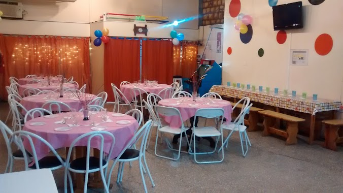
Venancio
104, Avenida Segurola, C1407, Comuna 10, Buenos Aires, AR Argentina
contacts phone
:
+54 11 4671-1712
website:
www.facebook.com
Latitude:
-34.6329684
, Longitude:
-58.4836943
larger map & directions
read more
nearest Food
94 m
ViKa Distribuidora
10 n° 1375 e/ 55 y 57, Mercedes
Food
read more
411 m
Confiteria la vienesa
Joaquin v gonzales 111, Buenos Aires
Food
read more
509 m
SALÓN DE FIESTAS INFANTILES COLORES MULTIEVENTOS
Avenida Rivadavia 8138
Food
read more
746 m
EVENTOS AZUL
Azul 41
Food
read more
746 m
AQUi se come BiEN
José Bonifacio 3902
Food
read more
771 m
POWER PANCH
José Bonifacio 4098
Food
read more
880 m
mayo
Avenida Rivadavia 9116, C1407DZN
Food
read more
884 m
Agua Fama
Carrasco 550
Food
read more
905 m
SALÓN DE FIESTAS VUELTA DE CIRCO
Avenida Juan Bautista Justo 6909
Food
read more
916 m
Eventos Jijus
Mercedes 918
Food
read more
973 m
Consulting S.R.L.
Carrasco 625
Food
read more
977 m
Puro Chocolate
Bermudez 53, Capital Federal, Capital Federal
Food
read more
1.016 km
El Buffet del Club Villa Luro
Bermúdez 526
Food
read more
1.046 km
Frigorífico Las Cabañas
Avenida Gaona 4000
Food
read more
1.266 km
Frigorífico Saga Saica
Avenida Directorio 3136
Food
read more
1.446 km
Granja Alberdi
Avenida Juan Bautista Alberdi 4749
Food
read more
1.448 km
Gfcatering
Leopardi 152, Buenos Aires
Food
read more
1.504 km
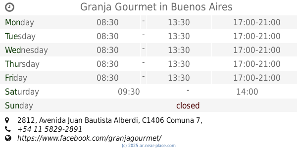
Granja Gourmet
Avenida Juan Bautista Alberdi 2812
Food
read more
1.506 km
Dacao's
Bermúdez 1052
Food
read more
1.52 km
Anamilo Srl (Blend)
1299, C1416BGG, Campana 1247
Food
read more
1.568 km
Migas del Angel- Pan Entero Cortado - Blanco/negro
Alejandro Magariños Cervantes 4635
Food
read more
1.656 km
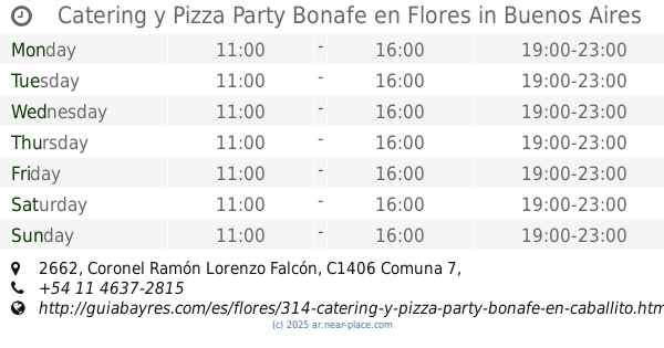
Catering y Pizza Party Bonafe en Flores
Coronel Ramón Lorenzo Falcón 2662
Food
read more
1.705 km
COMEDOR COMUNITARIO 7 ESQUINAS
Avenida Escalada 785
Food
read more
2.026 km
ESTURION
Remedios Escalada de San Martín 2894
Food
read more
2.524 km
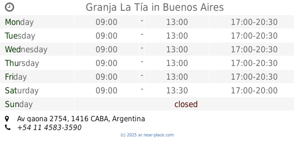
Granja La Tía
Av gaona 2754
Food
read more
📑
all categories
Accounting
Administrative area level 1
Administrative area level 2
Airport
Amusement park
Aquarium
Art gallery
Atm
Bakery
Bank
Bar
Beauty salon
Bicycle store
Book store
Bowling alley
Bus station
Cafe
Campground
Car dealer
Car rental
Car repair
Car wash
Casino
Cemetery
Church
City hall
Clothing store
Colloquial area
Convenience store
Country
Courthouse
Dentist
Department store
Doctor
Electrician
Electronics store
Embassy
Establishment
Finance
Fire station
Florist
Food
Funeral home
Furniture store
Gas station
General contractor
Grocery or supermarket
Gym
Hair care
Hardware store
Health
Hindu Temple
Home goods store
Hospital
Insurance agency
Intersection
Jewelry store
Laundry
Lawyer
Library
Light rail station
Liquor store
Local government office
Locality
Locksmith
Lodging
Meal delivery
Meal takeaway
Mosque
Movie rental
Movie theater
Moving company
Museum
Natural feature
Neighborhood
Night club
Painter
Park
Parking
Pet store
Pharmacy
Physiotherapist
Place of worship
Plumber
Point of interest
Police
Political
Post office
Premise
Real estate agency
Restaurant
Roofing contractor
Route
Rv park, camping
School
Shoe store
Shopping mall
Spa
Stadium
Storage
Store
Subpremise
Subway station
Supermarket
Synagogue
Taxi stand
Train station
Transit station
Travel agency
University
Veterinary care
Zoo
sublocality level 1
sublocality level 3
↑