Gas station nearby Esso
Argentina
Gas station nearby Esso
Esso
926, Belgrano, X5000, Córdoba, Capital, AR Argentina
contacts phone
:
+54
Latitude:
-31.4258045
, Longitude:
-64.1929238
larger map & directions
read more
nearest Gas station
20 m
Shell
998 X5000JQT, Belgrano 976, Córdoba
Gas station
read more
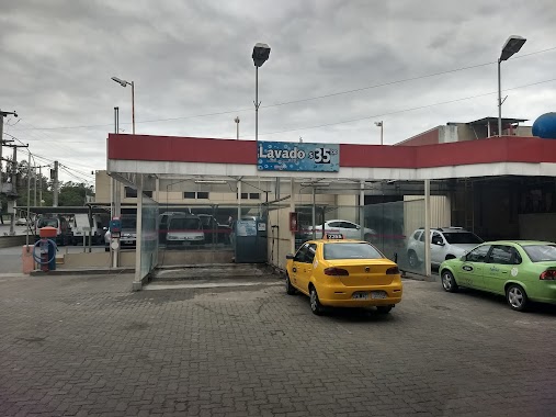
158 m
Lavadero De Autos
Avenida Pueyrredón 413-433, Córdoba
Gas station
read more
158 m
Car wash
Avenida Pueyrredón 413-433, Córdoba
Gas station
read more
489 m
Estación de Servicio YPF
Córdoba
Gas station
read more
493 m
YPF
Av. Vélez Sarsfield 526, Córdoba
Gas station
read more
493 m
YPF Service Station
Av. Vélez Sarsfield 526, Córdoba
Gas station
read more
494 m
Estacion YPF Acuña
Córdoba
Gas station
read more
505 m
YPF
Avenida M.S De, Sánchez de Loria 5085, Córdoba
Gas station
read more
511 m
YPF
Ruta Nacional 60 Km 822, Dean Funes
Gas station
read more
567 m
YPF
Avenida Pueyrredón 790, Córdoba
Gas station
read more
567 m
YPF Service Station
Avenida Pueyrredón 790, Córdoba
Gas station
read more
590 m
YPF Rusen SA
General Artigas 987, Córdoba
Gas station
read more
608 m
YPF
Avenida Presidente Hipólito Irigoyen 379, La Carlota
Gas station
read more
988 m
Esso San Juan
San Juan 850, Mar del Plata
Gas station
read more
1.005 km
Servicentro San Juan
Boulevard San Juan 870-898, Córdoba
Gas station
read more
1.014 km
Esso
Boulevard San Juan 890, Córdoba
Gas station
read more
1.026 km
Axion Energy
Bv. San Juan 890, Centro, Córdoba
Gas station
read more
1.036 km
Esso
Av. Vélez Sarsfield 1732, Cáceres, Córdoba
Gas station
read more
1.397 km
Esso Gnc
Córdoba
Gas station
read more
1.614 km
Cria 1. Cuerpo De Vigilancia Especial Policía
299, X5000HWE, Balcarce 199, Córdoba
Gas station
read more
1.799 km
Esso
Rosario de Santa Fe 600, Córdoba
Gas station
read more
1.986 km
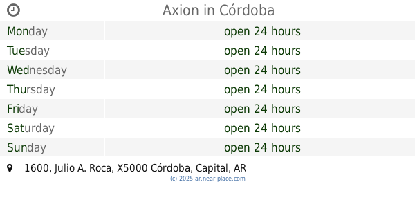
Axion
Julio A. Roca 1600, Córdoba
Gas station
read more
2.26 km
Pavone IV
Córdoba
Gas station
read more
2.277 km
Esso
Boulevard Guzmán 500-598, X5000FJS
Gas station
read more
2.555 km
YPF
Libertad S/N, Córdoba
Gas station
read more
📑
all categories
Accounting
Administrative area level 1
Administrative area level 2
Airport
Amusement park
Aquarium
Art gallery
Atm
Bakery
Bank
Bar
Beauty salon
Bicycle store
Book store
Bowling alley
Bus station
Cafe
Campground
Car dealer
Car rental
Car repair
Car wash
Casino
Cemetery
Church
City hall
Clothing store
Colloquial area
Convenience store
Country
Courthouse
Dentist
Department store
Doctor
Electrician
Electronics store
Embassy
Establishment
Finance
Fire station
Florist
Food
Funeral home
Furniture store
Gas station
General contractor
Grocery or supermarket
Gym
Hair care
Hardware store
Health
Hindu Temple
Home goods store
Hospital
Insurance agency
Intersection
Jewelry store
Laundry
Lawyer
Library
Light rail station
Liquor store
Local government office
Locality
Locksmith
Lodging
Meal delivery
Meal takeaway
Mosque
Movie rental
Movie theater
Moving company
Museum
Natural feature
Neighborhood
Night club
Painter
Park
Parking
Pet store
Pharmacy
Physiotherapist
Place of worship
Plumber
Point of interest
Police
Political
Post office
Premise
Real estate agency
Restaurant
Roofing contractor
Route
Rv park, camping
School
Shoe store
Shopping mall
Spa
Stadium
Storage
Store
Subpremise
Subway station
Supermarket
Synagogue
Taxi stand
Train station
Transit station
Travel agency
University
Veterinary care
Zoo
sublocality level 1
sublocality level 3
↑