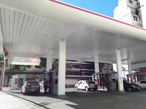
Gas station nearby Estacion De Servicio Axion
Argentina
Gas station nearby Estacion De Servicio Axion
Estacion De Servicio Axion
695-699, Avenida Cabildo, C1426, Comuna 14, Buenos Aires, AR Argentina
contacts phone
:
+54
Latitude:
-34.570352
, Longitude:
-58.4438485
larger map & directions
read more
nearest Gas station
12 m
AXION energy
Avenida Cabildo 695
Gas station
read more
709 m
YPF
Avenida Cabildo 1499, Buenos Aires
Gas station
read more
709 m
Y.P.F / A.C.A
Avenida Cabildo 1499
Gas station
read more
710 m
YPF A.C.A.
Gas station
read more
713 m
YPF
Avenida Cabildo 1499
Gas station
read more
968 m
YPF
Avenida del Libertador 5002, Buenos Aires
Gas station
read more
968 m
YPF
Avenida del Libertador 5002
Gas station
read more
1.257 km
Shell
1691, APA, Crámer
Gas station
read more
1.28 km
el carrefour
Mariscal Antonio José de Sucre 2490, C1428DVR
Gas station
read more
1.37 km
Garage Trabajo
C1428DRB, Echeverría 1642
Gas station
read more
1.494 km
Otro
Juramento, Buenos Aires
Gas station
read more
1.578 km
YPF
Avenida cordoba 5974 y dorrego
Gas station
read more
1.6 km
YPF
Avenida cordoba 5974
Gas station
read more
1.781 km
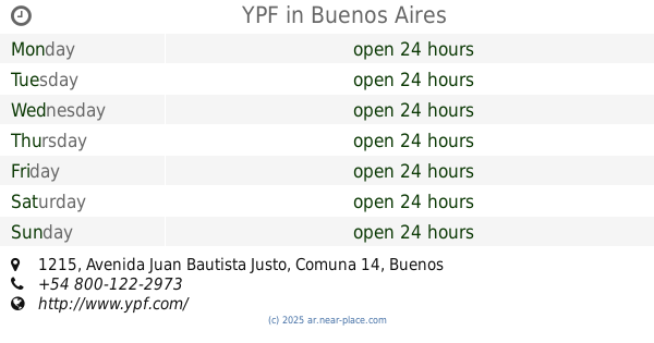
YPF
Avenida Juan Bautista Justo 1215
Gas station
read more
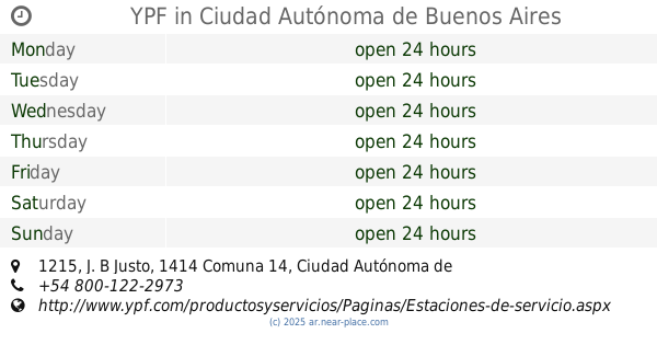
1.781 km
YPF
J. B Justo 1215
Gas station
read more
1.807 km
Shell
Avenida Juan Bautista Justo 1333
Gas station
read more
1.809 km
YPF
Avenida j. b. justo 1215 y nicaragua
Gas station
read more
1.834 km
OIL EXPRESS
Avenida de los Incas 3550
Gas station
read more
1.834 km
AXION energy
Avenida de los Incas 3550
Gas station
read more
1.834 km
Axion
Avenida de los Incas 3550
Gas station
read more
1.838 km
YPF
Avenida Álvarez Thomas, Avenida Olazábal Y, Buenos Aires
Gas station
read more
1.843 km
Esso
Avenida Córdoba 5653
Gas station
read more
1.909 km
Naftas y G.N.C. Estación de Servicio
Avenida Juan Bautista Justo 1567
Gas station
read more
1.955 km
Cabildo And Azurduy Squere
Avenida Cabildo, Buenos Aires
Gas station
read more
1.979 km
YPF
Avenida Doctor Ricardo Balbín 1895, San Martin
Gas station
read more
📑
all categories
Accounting
Administrative area level 1
Administrative area level 2
Airport
Amusement park
Aquarium
Art gallery
Atm
Bakery
Bank
Bar
Beauty salon
Bicycle store
Book store
Bowling alley
Bus station
Cafe
Campground
Car dealer
Car rental
Car repair
Car wash
Casino
Cemetery
Church
City hall
Clothing store
Colloquial area
Convenience store
Country
Courthouse
Dentist
Department store
Doctor
Electrician
Electronics store
Embassy
Establishment
Finance
Fire station
Florist
Food
Funeral home
Furniture store
Gas station
General contractor
Grocery or supermarket
Gym
Hair care
Hardware store
Health
Hindu Temple
Home goods store
Hospital
Insurance agency
Intersection
Jewelry store
Laundry
Lawyer
Library
Light rail station
Liquor store
Local government office
Locality
Locksmith
Lodging
Meal delivery
Meal takeaway
Mosque
Movie rental
Movie theater
Moving company
Museum
Natural feature
Neighborhood
Night club
Painter
Park
Parking
Pet store
Pharmacy
Physiotherapist
Place of worship
Plumber
Point of interest
Police
Political
Post office
Premise
Real estate agency
Restaurant
Roofing contractor
Route
Rv park, camping
School
Shoe store
Shopping mall
Spa
Stadium
Storage
Store
Subpremise
Subway station
Supermarket
Synagogue
Taxi stand
Train station
Transit station
Travel agency
University
Veterinary care
Zoo
sublocality level 1
sublocality level 3
↑