Gas station nearby PDV SUR
Coronavirus disease (COVID-19) Situation
confirmed cases
10128845
deaths
130841
Argentina
Gas station nearby PDV SUR
PDV SUR
702, Avenida Doctor Honorio Pueyrredón, C1405, Comuna 6, Buenos Aires, AR Argentina
contacts phone
:
+54
website:
www.petrolera-conosur.com.ar
Latitude:
-34.6118905
, Longitude:
-58.4425148
larger map & directions
read more
nearest Gas station
441 m
YPF
Colpayo 406
Gas station
read more
575 m
YPF
Av. Gaona 1204
Gas station
read more
580 m
YPF
1416 Buenos Aires, Argentina
Gas station
read more
580 m
YPF
1416 CABA, Argentina
Gas station
read more
580 m
YPF
Gas station
read more
695 m
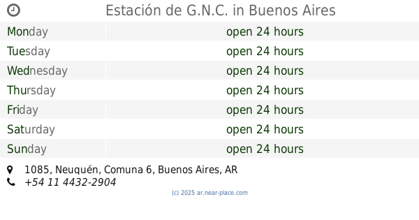
Estación de G.N.C.
Neuquén 1085
Gas station
read more
708 m
Petrobras G.N.C. Naftas
Avenida Angel Gallardo 699
Gas station
read more
714 m
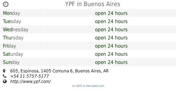
YPF
Espinosa 605, Buenos Aires
Gas station
read more
723 m
YPF Full
Méndez de Andes 957
Gas station
read more
727 m
YPF
Espinosa 605
Gas station
read more
756 m
CNG Service Station
Avenida Gaona 1501
Gas station
read more
773 m
GNC
Avenida Avellaneda 260
Gas station
read more
773 m
Estacion Ale
Avenida Avellaneda 260
Gas station
read more
992 m
YPF
Leopoldo Marechal 1336
Gas station
read more
992 m
AXION energy
Avenida SAN MARTIN Y LUIS VIALE
Gas station
read more
1.006 km
YPF
Avenida Warnes 236, Buenos Aires
Gas station
read more
1.115 km
YPF
Granadero Baigorria 25, Tres Lomas
Gas station
read more
1.361 km
taller Garcia
C1406BRG, Almirante F. J. Seguí 511
Gas station
read more
1.437 km
Combustible Warnes
Avenida Warnes 880
Gas station
read more
1.735 km
Vovchuk
Rojas 2051-2099
Gas station
read more
1.749 km
Estación de Servicio Axion
C1424BYA, Avenida Juan Bautista Alberdi 1-23
Gas station
read more
1.941 km
Me Bajo 126
Avenida Directorio 1101-1199, C1406GZA
Gas station
read more
1.962 km
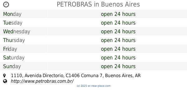
PETROBRAS
Avenida Directorio 1110
Gas station
read more
2.037 km
Prestogas Sa
Av Boyac� 1018
Gas station
read more
2.257 km
Gomeria
C1181ACR, Gascón 992
Gas station
read more
📑
all categories
Accounting
Administrative area level 1
Administrative area level 2
Airport
Amusement park
Aquarium
Art gallery
Atm
Bakery
Bank
Bar
Beauty salon
Bicycle store
Book store
Bowling alley
Bus station
Cafe
Campground
Car dealer
Car rental
Car repair
Car wash
Casino
Cemetery
Church
City hall
Clothing store
Colloquial area
Convenience store
Country
Courthouse
Dentist
Department store
Doctor
Electrician
Electronics store
Embassy
Establishment
Finance
Fire station
Florist
Food
Funeral home
Furniture store
Gas station
General contractor
Grocery or supermarket
Gym
Hair care
Hardware store
Health
Hindu Temple
Home goods store
Hospital
Insurance agency
Intersection
Jewelry store
Laundry
Lawyer
Library
Light rail station
Liquor store
Local government office
Locality
Locksmith
Lodging
Meal delivery
Meal takeaway
Mosque
Movie rental
Movie theater
Moving company
Museum
Natural feature
Neighborhood
Night club
Painter
Park
Parking
Pet store
Pharmacy
Physiotherapist
Place of worship
Plumber
Point of interest
Police
Political
Post office
Premise
Real estate agency
Restaurant
Roofing contractor
Route
Rv park, camping
School
Shoe store
Shopping mall
Spa
Stadium
Storage
Store
Subpremise
Subway station
Supermarket
Synagogue
Taxi stand
Train station
Transit station
Travel agency
University
Veterinary care
Zoo
sublocality level 1
sublocality level 3
↑