Gas station nearby Shell
Argentina
Gas station nearby Shell
Shell
3684, Paraná, Olivos, Vicente López, AR Argentina
contacts phone
:
+54
Latitude:
-34.5086
, Longitude:
-58.5211604
larger map & directions
read more
nearest Gas station
315 m
Esso
Paraná 3944, Olivos
Gas station
read more
345 m
Esso - GNC
Habana 255, Olivos
Gas station
read more
345 m
Axion Energy
Habana 255, Olivos
Gas station
read more
355 m
Esso
Parana 3944 Esq. Blas Parera, Olivos
Gas station
read more
376 m
Automóvil Club Argentino
Ruta Panamericana 3802, Olivos
Gas station
read more
505 m
YPF
Ruta Nacional Panamericana Km Y, Debenedetti, Olivos
Gas station
read more
509 m
YPF debenedetti Descendentte
Panamericana y acceso Debenedetti, Olivos
Gas station
read more
518 m
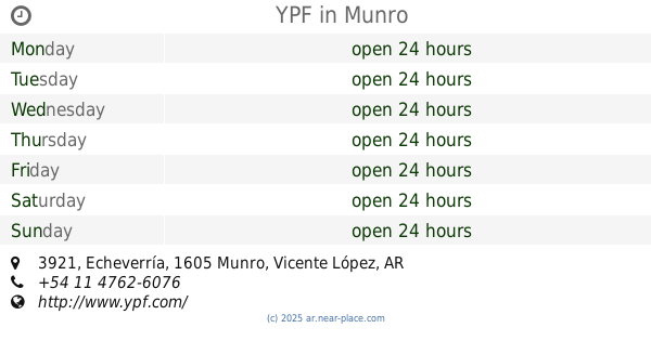
YPF
Debenedetti 2215, Munro
Gas station
read more
527 m
Ypf FULL
Debenedetti 2215, Munro
Gas station
read more
546 m
AXION energy
Paraná 4106, Olivos
Gas station
read more
546 m
Axion - GNC.
Paraná 4106, Olivos
Gas station
read more
557 m
YPF
Edison 2680, Martínez
Gas station
read more
576 m
YPF
Echeverría 3921, Munro
Gas station
read more
578 m
YPF
La, Avenida Tomás A. Edison, Habana Y, Martínez
Gas station
read more
616 m
Golonorte Golosinas
B1640DME, Habana 2299, Martínez
Gas station
read more
616 m
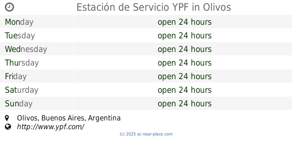
Estación de Servicio YPF
Olivos
Gas station
read more
616 m
YPF Service Station
Olivos
Gas station
read more
618 m
YPF Minishop
Acceso A Echeverría, Munro
Gas station
read more
623 m
Esso
Coronel Manuel Rosetti 3685, Olivos
Gas station
read more
1.018 km
Shell
Vicente López
Gas station
read more
1.019 km
Mini Chelo Irigiyen Gas
2075, B1640DSA, Puerto Rico 2001, Martínez
Gas station
read more
1.021 km
CNG station Yrigoyen SRL
Hipólito Yrigoyen 2810, Vicente López
Gas station
read more
1.021 km
Estación GNC Yrigoyen
Hipólito Yrigoyen 2810, Vicente López
Gas station
read more
1.034 km
estacion de servicio
B1640DSA, Puerto Rico 2001, Martínez
Gas station
read more
1.232 km
Esso
M. Pelliza Y Rosseti 3685, Olivos
Gas station
read more
📑
all categories
Accounting
Administrative area level 1
Administrative area level 2
Airport
Amusement park
Aquarium
Art gallery
Atm
Bakery
Bank
Bar
Beauty salon
Bicycle store
Book store
Bowling alley
Bus station
Cafe
Campground
Car dealer
Car rental
Car repair
Car wash
Casino
Cemetery
Church
City hall
Clothing store
Colloquial area
Convenience store
Country
Courthouse
Dentist
Department store
Doctor
Electrician
Electronics store
Embassy
Establishment
Finance
Fire station
Florist
Food
Funeral home
Furniture store
Gas station
General contractor
Grocery or supermarket
Gym
Hair care
Hardware store
Health
Hindu Temple
Home goods store
Hospital
Insurance agency
Intersection
Jewelry store
Laundry
Lawyer
Library
Light rail station
Liquor store
Local government office
Locality
Locksmith
Lodging
Meal delivery
Meal takeaway
Mosque
Movie rental
Movie theater
Moving company
Museum
Natural feature
Neighborhood
Night club
Painter
Park
Parking
Pet store
Pharmacy
Physiotherapist
Place of worship
Plumber
Point of interest
Police
Political
Post office
Premise
Real estate agency
Restaurant
Roofing contractor
Route
Rv park, camping
School
Shoe store
Shopping mall
Spa
Stadium
Storage
Store
Subpremise
Subway station
Supermarket
Synagogue
Taxi stand
Train station
Transit station
Travel agency
University
Veterinary care
Zoo
sublocality level 1
sublocality level 3
↑