Gas station nearby YPF
Argentina
Gas station nearby YPF
YPF
Córdoba, Donado y, Rosario Argentina
contacts phone
:
+54
Latitude:
-32.9440931
, Longitude:
-60.650678
read more
nearest Gas station
259 m
Shell Estación De Servicio
Boulevard Oroño 802-836, Rosario
Gas station
read more
267 m
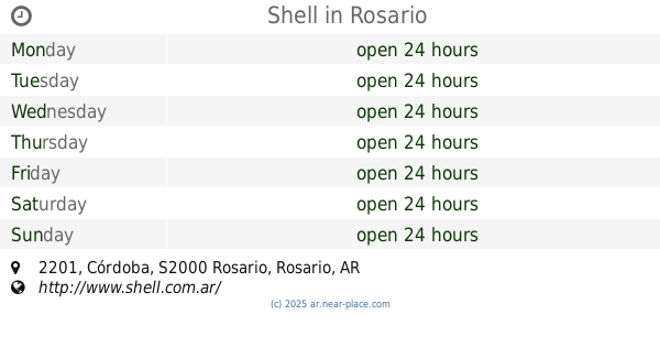
Shell
Córdoba 2201, Rosario
Gas station
read more
276 m
Azul Combustibles
Boulevard Oroño 797, Rosario
Gas station
read more
393 m
YPF
Mitre, Urquiza y, Rosario
Gas station
read more
418 m
Petrobras
España 902, Rosario
Gas station
read more
443 m
YPF
Santa Fe 1694, Rosario
Gas station
read more
448 m
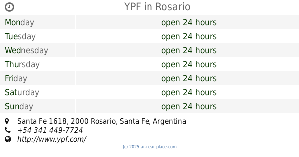
YPF
Santa Fe 1618, Rosario
Gas station
read more
652 m
Subaru Rosario
S2000QIB, Pueyrredón 832, Rosario
Gas station
read more
755 m
PUMA ENERGY
Pueyrredón 1089, Rosario
Gas station
Book store
Meal takeaway
Restaurant
Store
Food
Point of interest
Establishment
read more
758 m
Petrobras
Pueyrredón 1089, Rosario
Gas station
read more
783 m
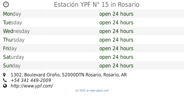
Estación YPF N° 15
Boulevard Oroño 1302, Rosario
Gas station
read more
794 m
Oroño ACA - YPF
3 de Febrero, Rosario
Gas station
read more
807 m
YPF station No.15
Boulevard Oroño 1302, Rosario
Gas station
read more
888 m
Axion Energy
Boulevard Oroño 1401, Rosario
Gas station
read more
889 m
ESSO Oroño
Boulevard Oroño 1401, Rosario
Gas station
read more
955 m
Shell
Corrientes 401, Rosario
Gas station
read more
955 m
Azul Combustibles SA
Corrientes 401, Rosario
Gas station
read more
1.006 km
AXION energy
Córdoba 2790, Rosario
Gas station
read more
1.006 km
Axion Energy - Spot
Córdoba 2790, Rosario
Gas station
read more
1.186 km
YPF
Salta, Callao y, Rosario
Gas station
read more
1.188 km
Shell
S2000BKY, 3 de Febrero 1283, Rosario
Gas station
read more
1.188 km
Estación de Servicio General Mosconi S.R.L. -YPF
Salta 2696, Rosario
Gas station
read more
1.235 km
Nani Mecanica Multimarca
S2000QIO, Pueyrredón 1557, Rosario
Gas station
read more
1.563 km
YPF
Avenida Estanislao López 2305, Humboldt
Gas station
read more
2.116 km
AXION energy
Avenida San Martín 1999, Rosario
Gas station
read more
📑
all categories
Accounting
Administrative area level 1
Administrative area level 2
Airport
Amusement park
Aquarium
Art gallery
Atm
Bakery
Bank
Bar
Beauty salon
Bicycle store
Book store
Bowling alley
Bus station
Cafe
Campground
Car dealer
Car rental
Car repair
Car wash
Casino
Cemetery
Church
City hall
Clothing store
Colloquial area
Convenience store
Country
Courthouse
Dentist
Department store
Doctor
Electrician
Electronics store
Embassy
Establishment
Finance
Fire station
Florist
Food
Funeral home
Furniture store
Gas station
General contractor
Grocery or supermarket
Gym
Hair care
Hardware store
Health
Hindu Temple
Home goods store
Hospital
Insurance agency
Intersection
Jewelry store
Laundry
Lawyer
Library
Light rail station
Liquor store
Local government office
Locality
Locksmith
Lodging
Meal delivery
Meal takeaway
Mosque
Movie rental
Movie theater
Moving company
Museum
Natural feature
Neighborhood
Night club
Painter
Park
Parking
Pet store
Pharmacy
Physiotherapist
Place of worship
Plumber
Point of interest
Police
Political
Post office
Premise
Real estate agency
Restaurant
Roofing contractor
Route
Rv park, camping
School
Shoe store
Shopping mall
Spa
Stadium
Storage
Store
Subpremise
Subway station
Supermarket
Synagogue
Taxi stand
Train station
Transit station
Travel agency
University
Veterinary care
Zoo
sublocality level 1
sublocality level 3
↑