Gas station nearby YPF Velez Sarsfield
Argentina
Gas station nearby YPF Velez Sarsfield
YPF Velez Sarsfield
901, Avenida Vélez Sarsfield, C1282, Comuna 4, Buenos Aires, AR Argentina
contacts phone
:
+54
Latitude:
-34.645423
, Longitude:
-58.3893711
larger map & directions
read more
nearest Gas station
70 m
YPF
Avenida dr velez sarsfield 850
Gas station
read more
71 m
YPF
Avenida Vélez Sarsfield 850, Buenos Aires
Gas station
read more
179 m
Capelo
-3200, Australia 3002, Buenos Aires
Gas station
read more
405 m
Transporte Maxi
Chubut 1250, 1202
Gas station
read more
498 m
GNC
600,, Avenida Vélez Sarsfield 532
Gas station
read more
500 m
Petrobras
Av. Vélez Sarsfield
Gas station
read more
500 m
Petrobras
Avenida Vélez Sarsfield
Gas station
read more
552 m
Ticket Car
C1296ABF, Australia 2524-2600
Gas station
read more
589 m
Gnc
Salom
Gas station
read more
921 m
YPF
Avenida Amancio Alcorta 2711, Buenos Aires
Gas station
read more
933 m
Shell Osde
Los Patos 1740
Gas station
read more
942 m
Naftas y Gnc Ghioldi Hnos
Los Patos 1740
Gas station
read more
945 m
Ghioldi Hnos
Los Patos 1718
Gas station
read more
1.549 km
Estacion de Servicio Pasgal
Atuel 1093
Gas station
read more
1.619 km
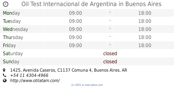
Oil Test Internacional de Argentina
Avenida Caseros 1425
Gas station
read more
1.738 km
ALBERTI 1870 GNC ESTACION DE CARGA
C1247AAN, Alberti 1870
Gas station
read more
1.793 km
Chochi Lavadero
1600 C1269AAH, Azara 1502
Gas station
read more
1.825 km
YPF Service Station
Avenida Amancio Alcorta 3415, Buenos Aires
Gas station
read more
1.825 km
YPF
Avenida Amancio Alcorta 3415, Buenos Aires
Gas station
read more
1.906 km
Darina Sa
J M Paz 2, Ituzaingo
Gas station
read more
1.928 km
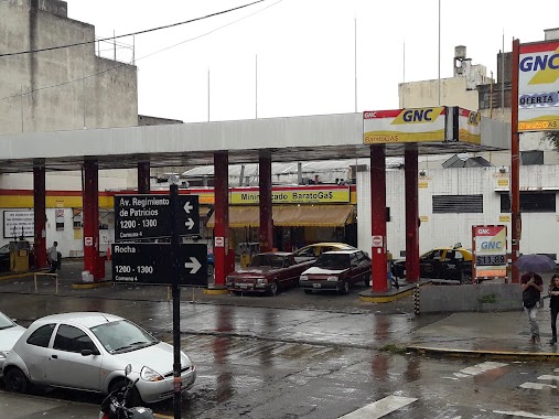
Barato Gas
Rocha 1200
Gas station
read more
1.944 km
YPF
Avenida Regimiento de Patricios, Tristan Suárez
Gas station
read more
2.118 km
Petrobras
Avenida Presidente Hipólito Yrigoyen 299, Gran Buenos Aires
Gas station
read more
2.163 km
Shell
Hipólito Yrigoyen 345, Avellaneda
Gas station
read more
2.239 km
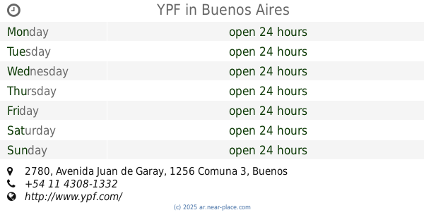
YPF
Avenida Juan de Garay 2780, Buenos Aires
Gas station
read more
📑
all categories
Accounting
Administrative area level 1
Administrative area level 2
Airport
Amusement park
Aquarium
Art gallery
Atm
Bakery
Bank
Bar
Beauty salon
Bicycle store
Book store
Bowling alley
Bus station
Cafe
Campground
Car dealer
Car rental
Car repair
Car wash
Casino
Cemetery
Church
City hall
Clothing store
Colloquial area
Convenience store
Country
Courthouse
Dentist
Department store
Doctor
Electrician
Electronics store
Embassy
Establishment
Finance
Fire station
Florist
Food
Funeral home
Furniture store
Gas station
General contractor
Grocery or supermarket
Gym
Hair care
Hardware store
Health
Hindu Temple
Home goods store
Hospital
Insurance agency
Intersection
Jewelry store
Laundry
Lawyer
Library
Light rail station
Liquor store
Local government office
Locality
Locksmith
Lodging
Meal delivery
Meal takeaway
Mosque
Movie rental
Movie theater
Moving company
Museum
Natural feature
Neighborhood
Night club
Painter
Park
Parking
Pet store
Pharmacy
Physiotherapist
Place of worship
Plumber
Point of interest
Police
Political
Post office
Premise
Real estate agency
Restaurant
Roofing contractor
Route
Rv park, camping
School
Shoe store
Shopping mall
Spa
Stadium
Storage
Store
Subpremise
Subway station
Supermarket
Synagogue
Taxi stand
Train station
Transit station
Travel agency
University
Veterinary care
Zoo
sublocality level 1
sublocality level 3
↑