Hospital nearby CER
Argentina
Hospital nearby CER
CER
2263, Humboldt, Comuna 15, Buenos Aires, AR Argentina
contacts phone
:
+54 11 4778-1587
website:
cermed.com
Latitude:
-34.5884724
, Longitude:
-58.4398858
larger map & directions
read more
nearest Hospital
237 m
QueNoDuelaMas
1300, C1414CML Bonpland 1232 C1414CML
Hospital
read more
437 m
CEMUVA
Avenida Córdoba 5869
Hospital
read more
676 m
Ciarec
Monroe 4770
Hospital
read more
687 m
Interea Salud Mental
C1414DCN, Thames 608
Hospital
read more
793 m
Sanatorio San Lucas
Thames 1565
Hospital
read more
819 m
Centro Médico Integral Fitz Roy
Acevedo 865
Hospital
read more
820 m
Clinica
Acevedo 833
Hospital
read more
821 m
Kiniseolojia
Acevedo 900-800
Hospital
read more
895 m
DR. JONES Beauty & Wellness
Avenida Dorrego 1835
Hospital
read more
1.004 km
Hotel big zeppeling 4000 el mes
C1414AZI, Lerma 451
Hospital
read more
1.057 km
Nuestra Señora de Las Nieves
Avenida Álvarez Thomas 268
Hospital
read more
1.072 km
Stamboulian Servicios de Salud
Avenida Raúl Scalabrini Ortíz 696
Hospital
read more
1.072 km
Stamboulian Health Services
Avenida Raúl Scalabrini Ortíz 696
Hospital
read more
1.151 km
Cermed
C1425FUB, Humboldt 2200
Hospital
read more
1.165 km
Swiss Medical Center
Guatemala 5455
Hospital
read more
1.165 km
Laburo Total
C1414DPP, Aráoz 750
Hospital
read more
1.165 km
Swiss Medical Center de los Arcos
Guatemala 5455, C1425BVE
Hospital
read more
1.187 km
Instituto Medico
C1425FUC, Humboldt 2217
Hospital
read more
1.257 km
Hospital
Darwin 243, C1414CUE
Hospital
read more
1.26 km
Los Arcos Sanatorium
Avenida Juan Bautista Justo 909
Hospital
read more
1.26 km
Sanatorio De Los Arcos
Avenida Juan Bautista Justo 909
Hospital
read more
1.347 km
Medico nueva zelanda
C1425FUE, Humboldt 2355
Hospital
read more
1.354 km
Clinica Dr Lantos
Humboldt 2355
Hospital
read more
1.419 km
中华医院
C1426CQS, Avenida Federico Lacroze 3272
Hospital
read more
2.011 km
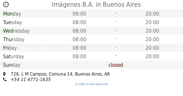
Imágenes B.A.
L M Campos 726
Hospital
read more
📑
all categories
Accounting
Administrative area level 1
Administrative area level 2
Airport
Amusement park
Aquarium
Art gallery
Atm
Bakery
Bank
Bar
Beauty salon
Bicycle store
Book store
Bowling alley
Bus station
Cafe
Campground
Car dealer
Car rental
Car repair
Car wash
Casino
Cemetery
Church
City hall
Clothing store
Colloquial area
Convenience store
Country
Courthouse
Dentist
Department store
Doctor
Electrician
Electronics store
Embassy
Establishment
Finance
Fire station
Florist
Food
Funeral home
Furniture store
Gas station
General contractor
Grocery or supermarket
Gym
Hair care
Hardware store
Health
Hindu Temple
Home goods store
Hospital
Insurance agency
Intersection
Jewelry store
Laundry
Lawyer
Library
Light rail station
Liquor store
Local government office
Locality
Locksmith
Lodging
Meal delivery
Meal takeaway
Mosque
Movie rental
Movie theater
Moving company
Museum
Natural feature
Neighborhood
Night club
Painter
Park
Parking
Pet store
Pharmacy
Physiotherapist
Place of worship
Plumber
Point of interest
Police
Political
Post office
Premise
Real estate agency
Restaurant
Roofing contractor
Route
Rv park, camping
School
Shoe store
Shopping mall
Spa
Stadium
Storage
Store
Subpremise
Subway station
Supermarket
Synagogue
Taxi stand
Train station
Transit station
Travel agency
University
Veterinary care
Zoo
sublocality level 1
sublocality level 3
↑