Local government office nearby CAFyS
Coronavirus disease (COVID-19) Situation
confirmed cases
10128845
deaths
130841
Argentina
Local government office nearby CAFyS
CAFyS
3002-3100, General Juan Andrés, B1618, El Talar, Tigre, AR Argentina
contacts phone
:
+54
Latitude:
-34.4839942
, Longitude:
-58.6609018
larger map & directions
read more
nearest Local government office
15 m
Comisaria 5ta El Talar
General Juan Andrés 3001, El Talar
Local government office
read more
90 m
Sub delegación Almirante Brown
Alemania & Gral. Lavalleja, El Talar
Local government office
read more
661 m
Peugeot
B1618EXW, Marcos Sastre 1121, El Talar
Local government office
read more
893 m
Ansessss
Colectora Oeste Ramal Pilar 12, El Talar
Local government office
read more
893 m
Anses Udai El Talar
Colectora Oeste Ramal Pilar 12, El Talar
Local government office
read more
1.023 km
UNIDAD PRIMARIA DE ATENCIÓN - Parque Alvear
5698,B1614DRJ, Tomás Godoy Cruz 5500, Villa de Mayo
Local government office
read more
1.268 km
UNIDAD PRIMARIA DE ATENCIÓN - La Loma
Pelagio Luna, Villa de Mayo
Local government office
read more
1.311 km
Nivel Truck S.R.L.
General Pacheco 2235, El Talar
Local government office
read more
1.711 km
Delegacion Municipal Adolfo Sourdeaux
5000, B1612EIP, Pío XII 4902, Ingeniero Adolfo Sourdeaux
Local government office
read more
2.218 km
UNIDAD PRIMARIA DE ATENCIÓN - Km. 30
4498,B1612EEF, Rosario 4400, Ingeniero Adolfo Sourdeaux
Local government office
read more
2.255 km
Esageon Seguridad Sa
Avenida del Sesquicentenario 4591, Ingeniero Pablo Nogués, Buenos Aires
Local government office
read more
2.321 km
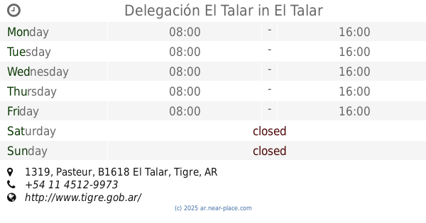
Delegación El Talar
B1618DAY, Pasteur 1319, El Talar
Local government office
read more
2.368 km
UNIDAD PRIMARIA DE ATENCIÓN - San Calal
4699,B1612CYG, Doctor Marcelo Fitte 4651, Ingeniero Adolfo Sourdeaux
Local government office
read more
2.379 km
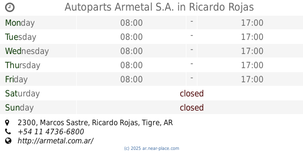
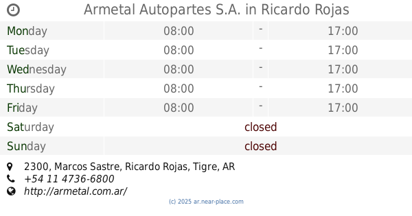
Autoparts Armetal S.A.
Marcos Sastre 2300, Ricardo Rojas
Local government office
read more
2.379 km
Armetal Autopartes S.A.
Marcos Sastre 2300, Ricardo Rojas
Local government office
read more
2.43 km
Estacion Provisoria Don Torcuato
Campo de Mayo
Local government office
read more
2.514 km
The 3rd police station. Don Torcuato Tiger
Avenida Ángel T. de Alvear 635, Gran Buenos Aires
Local government office
read more
2.514 km
Comisaría 3ra. de Tigre Don Torcuato
Avenida Ángel T. de Alvear 635, Gran Buenos Aires
Local government office
read more
2.542 km
Delegación La Paloma
Teniente General Juan José Valle 1871, Gran Buenos Aires
Local government office
read more
2.629 km
Local De Cabildo
4099, B1613AEK, Cabildo 4001, Los Polvorines
Local government office
read more
2.808 km
UNIDAD PRIMARIA DE ATENCIÓN - Polideportivo de Villa de Mayo
2498,, Rosario 2400, Villa de Mayo
Local government office
read more
3.368 km
Arba Oficinas
B1613AUQ, Avenida Presidente Juan Domingo Perón 3006-3048, Los Polvorines
Local government office
read more
3.404 km
UNIDAD PRIMARIA DE ATENCIÓN - Móvil 86 (San Eduardo)
1458,, Le Corbusier 1426, Area de Promoción El Triángulo
Local government office
read more
3.745 km
Cemento avellaneda Obrador
Colectora Oeste Panamericana 2071, Area de Promoción El Triángulo
Local government office
read more
3.822 km
Primore s.r.l.
Leonardo Da Vinci 5182, Area de Promoción El Triángulo
Local government office
read more
📑
all categories
Accounting
Administrative area level 1
Administrative area level 2
Airport
Amusement park
Aquarium
Art gallery
Atm
Bakery
Bank
Bar
Beauty salon
Bicycle store
Book store
Bowling alley
Bus station
Cafe
Campground
Car dealer
Car rental
Car repair
Car wash
Casino
Cemetery
Church
City hall
Clothing store
Colloquial area
Convenience store
Country
Courthouse
Dentist
Department store
Doctor
Electrician
Electronics store
Embassy
Establishment
Finance
Fire station
Florist
Food
Funeral home
Furniture store
Gas station
General contractor
Grocery or supermarket
Gym
Hair care
Hardware store
Health
Hindu Temple
Home goods store
Hospital
Insurance agency
Intersection
Jewelry store
Laundry
Lawyer
Library
Light rail station
Liquor store
Local government office
Locality
Locksmith
Lodging
Meal delivery
Meal takeaway
Mosque
Movie rental
Movie theater
Moving company
Museum
Natural feature
Neighborhood
Night club
Painter
Park
Parking
Pet store
Pharmacy
Physiotherapist
Place of worship
Plumber
Point of interest
Police
Political
Post office
Premise
Real estate agency
Restaurant
Roofing contractor
Route
Rv park, camping
School
Shoe store
Shopping mall
Spa
Stadium
Storage
Store
Subpremise
Subway station
Supermarket
Synagogue
Taxi stand
Train station
Transit station
Travel agency
University
Veterinary care
Zoo
sublocality level 1
sublocality level 3
↑