Lodging nearby Alquilo apto
Argentina
Lodging nearby Alquilo apto
Alquilo apto
97 Raulet Planta baja a la calle, C1437 Diamante, Buenos Aires, Argentina
contacts phone
:
+54
Latitude:
-34.6403952
, Longitude:
-58.4170515
larger map & directions
read more
nearest Lodging
516 m
Hotel León Familiar
C1262ABW, Rondeau 3469
Lodging
read more
527 m
Fernandez Selva L
Rondeau 3469
Lodging
read more
742 m
Caseros
Avenida Caseros 3221
Lodging
read more
782 m
Geriatrico Maria Reina
Senillosa 1941
Lodging
read more
806 m
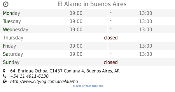
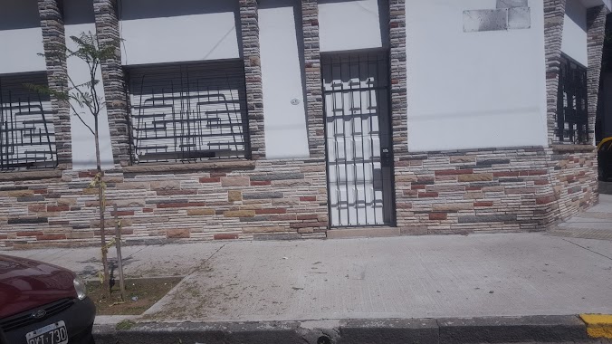
El Alamo
Enrique Ochoa 64
Lodging
read more
835 m
Lalín
Senillosa 1834
Lodging
read more
869 m
BTP City Apartments - bue
Avenida Brasil 3260
Lodging
read more
910 m
Leonardo Alonso García
24 de Noviembre 2050
Lodging
read more
912 m
Castro
Castro 1648
Lodging
read more
913 m
Hotel Castro
Castro 1644
Lodging
read more
943 m
Turismo
24 de Noviembre 2038
Lodging
read more
983 m
Pedro Echagüe
Lodging
read more
1.023 km
Hotel Maza Familiar
Maza 1733
Lodging
read more
1.083 km
Vanu TELLOP
Balbastro 630
Lodging
read more
1.095 km
El Colorado
Avenida Brasil 3088
Lodging
read more
1.14 km
hotel ospepri
1579 C1250AAF, Avenida La Plata 1541
Lodging
read more
1.175 km
Hotel Suite
Lodging
read more
1.406 km
Parque De La Costa
Somellera 1396 C1437JIL
Lodging
read more
1.433 km
La Casa De Lily
Esteban De Luca #2237 4 C, Buenos Aires
Lodging
read more
1.789 km
Navarro
Avenida San Juan 3315
Lodging
read more
1.798 km
Departamento Boedo
Humberto 1º 3519
Lodging
read more
1.929 km
Casa De Cielo
Avenida Caseros 2454
Lodging
read more
1.966 km
Fábrica de Pastas Laurimar
Avenida Caseros 2431
Lodging
read more
1.975 km
Hotel Mundo
Humberto 1º 3136
Lodging
read more
2.096 km
Graciela Belén
Avenida San Juan 2878
Lodging
read more
📑
all categories
Accounting
Administrative area level 1
Administrative area level 2
Airport
Amusement park
Aquarium
Art gallery
Atm
Bakery
Bank
Bar
Beauty salon
Bicycle store
Book store
Bowling alley
Bus station
Cafe
Campground
Car dealer
Car rental
Car repair
Car wash
Casino
Cemetery
Church
City hall
Clothing store
Colloquial area
Convenience store
Country
Courthouse
Dentist
Department store
Doctor
Electrician
Electronics store
Embassy
Establishment
Finance
Fire station
Florist
Food
Funeral home
Furniture store
Gas station
General contractor
Grocery or supermarket
Gym
Hair care
Hardware store
Health
Hindu Temple
Home goods store
Hospital
Insurance agency
Intersection
Jewelry store
Laundry
Lawyer
Library
Light rail station
Liquor store
Local government office
Locality
Locksmith
Lodging
Meal delivery
Meal takeaway
Mosque
Movie rental
Movie theater
Moving company
Museum
Natural feature
Neighborhood
Night club
Painter
Park
Parking
Pet store
Pharmacy
Physiotherapist
Place of worship
Plumber
Point of interest
Police
Political
Post office
Premise
Real estate agency
Restaurant
Roofing contractor
Route
Rv park, camping
School
Shoe store
Shopping mall
Spa
Stadium
Storage
Store
Subpremise
Subway station
Supermarket
Synagogue
Taxi stand
Train station
Transit station
Travel agency
University
Veterinary care
Zoo
sublocality level 1
sublocality level 3
↑