Lodging nearby Carvelle
Coronavirus disease (COVID-19) Situation
confirmed cases
10128845
deaths
130841
Argentina
Lodging nearby Carvelle
Carvelle
5395, Avenida Coronel Niceto Vega, Comuna 14, Buenos Aires, AR Argentina
contacts phone
:
+54
Latitude:
-34.5881744
, Longitude:
-58.4369102
larger map & directions
read more
nearest Lodging
190 m
OE
Humboldt 1464
Lodging
read more
264 m
Humboldt 1271
Humboldt 1201-1299, C1414CTG
Lodging
read more
347 m
Hotel Buenos Aires - Vacation 2015/2016
C1414CTP, Humboldt 1650
Lodging
read more
469 m
Casa Gorriti
Gorriti 5079
Lodging
read more
494 m
L'Hotel Palermo
Thames 1562
Lodging
read more
574 m
Syrah Suites
C1414CTS, Humboldt 1885
Lodging
read more
590 m
Aguirre
Uriarte 805
Lodging
read more
594 m
VyR Buenos Aires Palermo Hollywood
Humboldt 1897, 4° B, Buenos Aires
Lodging
read more
595 m
Hotel Bonpland
Bonpland 1785
Lodging
read more
636 m
COSTA PETIT HOTEL
Costa Rica 5141
Lodging
read more
804 m
Meridiano & Paralelo Hostel
Arévalo 1583
Lodging
read more
872 m
Soho Allsuite
Argentina
Lodging
read more
874 m
Didi Rooms
Honduras 4762
Lodging
read more
908 m
Dto Villa Crespo
Villarroel 1047
Lodging
read more
934 m
Casa Villa Crespo
Villarroel 1034
Lodging
read more
946 m
Soho Hotel
C1414BVJ, Nicaragua 4728
Lodging
read more
967 m
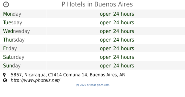
P Hotels
CP1414, Nicaragua 5867
Lodging
read more
990 m
Hotel Sandolfe
Ángel Justiniano Carranza 2082
Lodging
read more
1.003 km
70 30 Hostel
Soler 4829
Lodging
read more
1.008 km
CasaSur Palermo Hotel
Costa Rica 6028
Lodging
read more
1.021 km
PALERMO HOLLYWOOD-MODERNO ESTUDIO C/PILETA
Guatemala 5700
Lodging
read more
1.048 km
Silver Soho Suites
Uriarte 2135
Lodging
read more
1.054 km
Hotel Araoz
Aráoz 925
Lodging
read more
1.072 km
Amplio y Luminoso en Palermo Soho
Fray Justo Santa María de Oro 2192, 5 B, Buenos Aires
Lodging
read more
1.216 km
Hostel Suites Palermo
Charcas 4752
Lodging
read more
📑
all categories
Accounting
Administrative area level 1
Administrative area level 2
Airport
Amusement park
Aquarium
Art gallery
Atm
Bakery
Bank
Bar
Beauty salon
Bicycle store
Book store
Bowling alley
Bus station
Cafe
Campground
Car dealer
Car rental
Car repair
Car wash
Casino
Cemetery
Church
City hall
Clothing store
Colloquial area
Convenience store
Country
Courthouse
Dentist
Department store
Doctor
Electrician
Electronics store
Embassy
Establishment
Finance
Fire station
Florist
Food
Funeral home
Furniture store
Gas station
General contractor
Grocery or supermarket
Gym
Hair care
Hardware store
Health
Hindu Temple
Home goods store
Hospital
Insurance agency
Intersection
Jewelry store
Laundry
Lawyer
Library
Light rail station
Liquor store
Local government office
Locality
Locksmith
Lodging
Meal delivery
Meal takeaway
Mosque
Movie rental
Movie theater
Moving company
Museum
Natural feature
Neighborhood
Night club
Painter
Park
Parking
Pet store
Pharmacy
Physiotherapist
Place of worship
Plumber
Point of interest
Police
Political
Post office
Premise
Real estate agency
Restaurant
Roofing contractor
Route
Rv park, camping
School
Shoe store
Shopping mall
Spa
Stadium
Storage
Store
Subpremise
Subway station
Supermarket
Synagogue
Taxi stand
Train station
Transit station
Travel agency
University
Veterinary care
Zoo
sublocality level 1
sublocality level 3
↑