Meal takeaway nearby Green Feel
Coronavirus disease (COVID-19) Situation
confirmed cases
10128845
deaths
130841
Argentina
Meal takeaway nearby Green Feel
Green Feel
2986, Avenida Corrientes, C1193, Comuna 3, Buenos Aires, AR Argentina
contacts phone
:
+54
Latitude:
-34.604395
, Longitude:
-58.407607
larger map & directions
read more
nearest Meal takeaway
154 m
Wanda Nadia Cansinos Garcia
Boulogne Sur Mer 590, Boulogne Sur Mer
Meal takeaway
read more
627 m
TiFOSi
Azcuénaga 411
Meal takeaway
read more
707 m
EL SOL
Lavalle 2331
Meal takeaway
read more
730 m
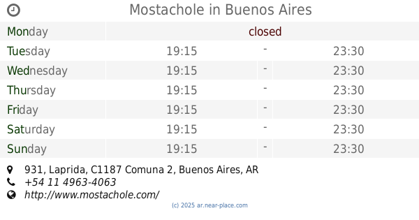
Mostachole
C1187ABA, Laprida 931
Meal takeaway
read more
741 m
Rotisería Almagro
Billinghurst 647
Meal takeaway
read more
745 m
Camila
Billinghurst 552
Meal takeaway
read more
786 m
Almacen General
Pasteur 672
Meal takeaway
read more
800 m
Chen Tai An
Avenida Hipólito Yrigoyen 2772
Meal takeaway
read more
820 m
Tiendas Cook
Pasteur 715
Meal takeaway
read more
832 m
Me Gusta
Pasteur 750
Meal takeaway
read more
852 m
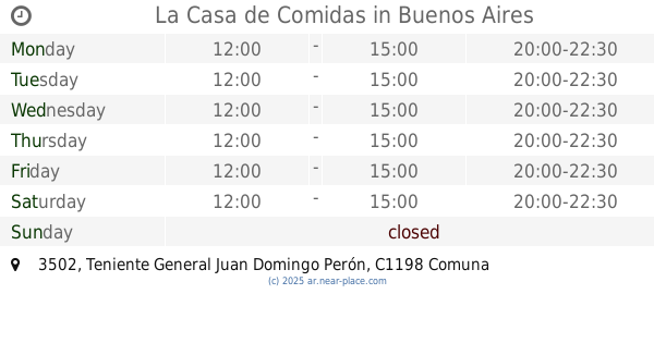
La Casa de Comidas
Teniente General Juan Domingo Perón 3502
Meal takeaway
read more
877 m
Pinón
Sarmiento 2227
Meal takeaway
read more
904 m
NUEVO Vero
Avenida Corrientes 2168
Meal takeaway
read more
920 m
El Gallito de Oro
Adolfo Alsina 2699
Meal takeaway
read more
944 m
Fortunato
Avenida Jujuy 211
Meal takeaway
read more
968 m
Rosa Cardenilla
Matheu 78
Meal takeaway
read more
970 m
Restaurante Diamante
Avenida Corrientes 2115
Meal takeaway
read more
1000 m
Empanadas Estilo Casero
Avenida Rivadavia 3489
Meal takeaway
read more
1.006 km
La Abuela Elicenda
Junín 575
Meal takeaway
read more
1.01 km
Café-Bar Río Nalón
Sarmiento 2108
Meal takeaway
read more
1.031 km
Selser M y C
Billinghurst 10
Meal takeaway
read more
1.049 km
Natural Verde
Avenida Rivadavia 2214
Meal takeaway
read more
1.062 km
La Casa
Junín 757
Meal takeaway
read more
1.152 km
Rotisería Yi Long Xuan
Virrey Liniers 193, C1174ACA
Meal takeaway
read more
1.345 km
Veggie Club
1087, Junín
Meal takeaway
read more
📑
all categories
Accounting
Administrative area level 1
Administrative area level 2
Airport
Amusement park
Aquarium
Art gallery
Atm
Bakery
Bank
Bar
Beauty salon
Bicycle store
Book store
Bowling alley
Bus station
Cafe
Campground
Car dealer
Car rental
Car repair
Car wash
Casino
Cemetery
Church
City hall
Clothing store
Colloquial area
Convenience store
Country
Courthouse
Dentist
Department store
Doctor
Electrician
Electronics store
Embassy
Establishment
Finance
Fire station
Florist
Food
Funeral home
Furniture store
Gas station
General contractor
Grocery or supermarket
Gym
Hair care
Hardware store
Health
Hindu Temple
Home goods store
Hospital
Insurance agency
Intersection
Jewelry store
Laundry
Lawyer
Library
Light rail station
Liquor store
Local government office
Locality
Locksmith
Lodging
Meal delivery
Meal takeaway
Mosque
Movie rental
Movie theater
Moving company
Museum
Natural feature
Neighborhood
Night club
Painter
Park
Parking
Pet store
Pharmacy
Physiotherapist
Place of worship
Plumber
Point of interest
Police
Political
Post office
Premise
Real estate agency
Restaurant
Roofing contractor
Route
Rv park, camping
School
Shoe store
Shopping mall
Spa
Stadium
Storage
Store
Subpremise
Subway station
Supermarket
Synagogue
Taxi stand
Train station
Transit station
Travel agency
University
Veterinary care
Zoo
sublocality level 1
sublocality level 3
↑