Meal takeaway nearby Kiero 2 Pancheria
Argentina
Meal takeaway nearby Kiero 2 Pancheria
Kiero 2 Pancheria
454, Camargo, C1414, Comuna 15, Buenos Aires, AR Argentinien
contacts phone
:
+54
Latitude:
-34.6009932
, Longitude:
-58.4397088
larger map & directions
read more
nearest Meal takeaway
169 m
Florentina Almacén de Sabores
Padilla 579
Meal takeaway
read more
202 m
Bien de Campo - Empanadas
Avenida Corrientes 5131
Meal takeaway
read more
250 m
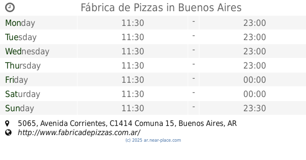
Fábrica de Pizzas
Avenida Corrientes 5065
Meal takeaway
read more
292 m
Muzzarella
Aráoz 405
Meal takeaway
read more
388 m
Rotisería Arce
Avenida Acoyte 1437
Meal takeaway
read more
411 m
S M PIZZERÍA
Avenida Acoyte 1510
Meal takeaway
read more
436 m
El Recreo
Padilla
Meal takeaway
read more
498 m
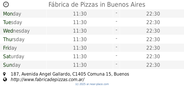
Fábrica de Pizzas
Avenida Angel Gallardo 187
Meal takeaway
read more
528 m
Lo de Mili
Muñecas 769
Meal takeaway
read more
569 m
Merco Sur
Coronel Apolinario Figueroa 241
Meal takeaway
read more
657 m
Rotisería Cümen
Juan Ramirez de Velasco 873
Meal takeaway
read more
691 m
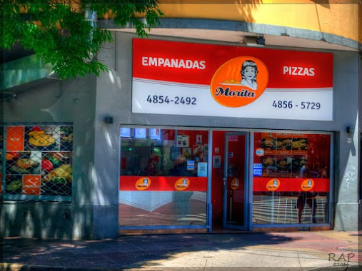
Morita
Avenida Corrientes 5699
Meal takeaway
read more
729 m
Reke
AQT, Juan Ramirez de Velasco 942
Meal takeaway
read more
747 m
Bellaflor
Gurruchaga 877
Meal takeaway
read more
786 m
Noble y Natural
Avenida Corrientes 4657
Meal takeaway
read more
793 m
Honkom
Avenida Corrientes 4657
Meal takeaway
read more
806 m
Potenza
Juan Ramirez de Velasco 1005
Meal takeaway
read more
882 m
Gastón & David
Luis Viale 516
Meal takeaway
read more
887 m
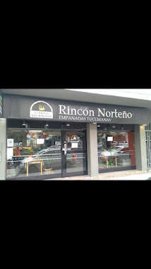
Rincón Norteño
Avenida Estado de Israel 4585
Meal takeaway
read more
887 m
Sabores Nuestros
Lambaré 1102
Meal takeaway
read more
887 m
Sabores Nuestros
Avenida Lambaré 1102
Meal takeaway
read more
1.01 km
Del Domingo
Lerma 312
Meal takeaway
read more
1.018 km
Cutter's
Avenida Doctor Honorio Pueyrredón, Buenos Aires
Meal takeaway
read more
1.106 km
La Barra
Avenida Córdoba 4770
Meal takeaway
read more
1.112 km
Bon Appétit
Avenida Gaona 1303
Meal takeaway
read more
📑
all categories
Accounting
Administrative area level 1
Administrative area level 2
Airport
Amusement park
Aquarium
Art gallery
Atm
Bakery
Bank
Bar
Beauty salon
Bicycle store
Book store
Bowling alley
Bus station
Cafe
Campground
Car dealer
Car rental
Car repair
Car wash
Casino
Cemetery
Church
City hall
Clothing store
Colloquial area
Convenience store
Country
Courthouse
Dentist
Department store
Doctor
Electrician
Electronics store
Embassy
Establishment
Finance
Fire station
Florist
Food
Funeral home
Furniture store
Gas station
General contractor
Grocery or supermarket
Gym
Hair care
Hardware store
Health
Hindu Temple
Home goods store
Hospital
Insurance agency
Intersection
Jewelry store
Laundry
Lawyer
Library
Light rail station
Liquor store
Local government office
Locality
Locksmith
Lodging
Meal delivery
Meal takeaway
Mosque
Movie rental
Movie theater
Moving company
Museum
Natural feature
Neighborhood
Night club
Painter
Park
Parking
Pet store
Pharmacy
Physiotherapist
Place of worship
Plumber
Point of interest
Police
Political
Post office
Premise
Real estate agency
Restaurant
Roofing contractor
Route
Rv park, camping
School
Shoe store
Shopping mall
Spa
Stadium
Storage
Store
Subpremise
Subway station
Supermarket
Synagogue
Taxi stand
Train station
Transit station
Travel agency
University
Veterinary care
Zoo
sublocality level 1
sublocality level 3
↑