Neighborhood nearby Centro de Reciclaje de la Ciudad
Coronavirus disease (COVID-19) Situation
confirmed cases
10128845
deaths
130841
Argentina
Neighborhood nearby Centro de Reciclaje de la Ciudad
Centro de Reciclaje de la Ciudad
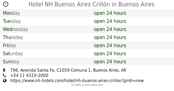
2750, Ana María Janer, C1437, Comuna 8, Buenos Aires, AR Argentina
contacts phone
:
+54 11 2150-6995
Latitude:
-34.654543
, Longitude:
-58.4433989
larger map & directions
read more
nearest Neighborhood
3.177 km
Varela
Flores
Neighborhood
read more
5.191 km
Centro Deportivo Ibiza
Centro Deportivo Ibiza, Pola 1263
Neighborhood
read more
5.205 km
Cristales Caba
Cristales Caba, Sor Juana Inés de la Cruz 1446
Neighborhood
read more
6.504 km
Villa Insuperable
La Tablada
Neighborhood
read more
7.475 km
Villa Ansaldi
La Tablada
Neighborhood
read more
7.742 km
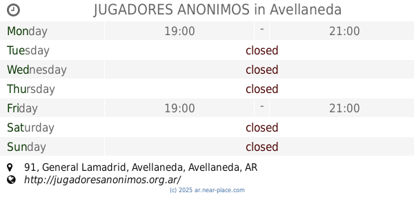
JUGADORES ANONIMOS
JUGADORES ANONIMOS, General Lamadrid 91, Avellaneda
Neighborhood
read more
8.183 km
Centro
San Nicolas
Neighborhood
read more
8.197 km
Barrio Norte
Recoleta
Neighborhood
read more
8.261 km
Isla Maciel
Isla Maciel, 531,B1871DIK, General Rivas 517, Dock Sud
Neighborhood
read more
8.309 km
Isla Maciel
Dock Sud
Neighborhood
read more
8.394 km
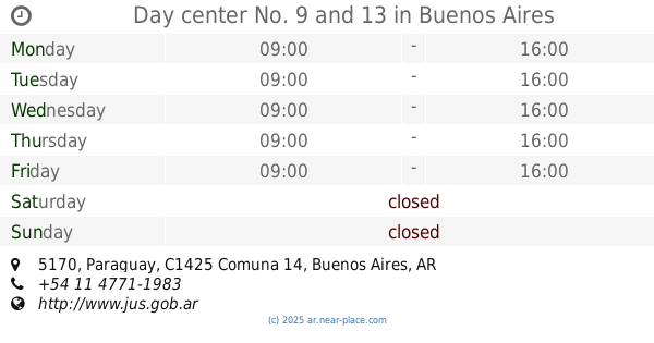
Day center No. 9 and 13
Day center No. 9 and 13, Paraguay 5170
Neighborhood
read more
8.394 km
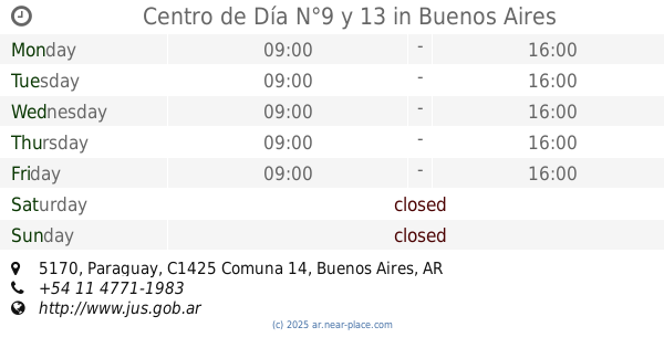
Centro de Día N°9 y 13
Centro de Día N°9 y 13, Paraguay 5170
Neighborhood
read more
8.887 km
Hotel NH Buenos Aires Crillón
Hotel NH Buenos Aires Crillón, Avenida Santa Fe 796
Neighborhood
read more
8.971 km
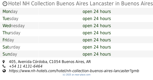
Hotel NH Collection Buenos Aires Lancaster
Av. Córdoba 405
Neighborhood
read more
8.971 km
Hotel NH Collection Buenos Aires Lancaster
Hotel NH Collection Buenos Aires Lancaster, Avenida Córdoba 405
Neighborhood
read more
8.982 km
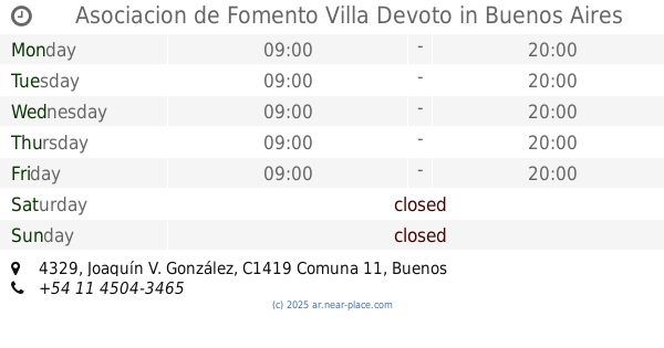
Asociacion de Fomento Villa Devoto
Asociacion de Fomento Villa Devoto, Joaquín V. González 4329
Neighborhood
read more
10.268 km
Barrio Chino
Belgrano
Neighborhood
read more
10.634 km
Obrero Santa Catalina
Ingeniero Budge
Neighborhood
read more
12.351 km
Peatonal Calle Laprida
Peatonal Calle Laprida, Laprida e hipolito irigoyen lomas de zamora, Avenida Presidente Hipólito Yrigoyen, Lomas de Zamora
Neighborhood
read more
12.432 km
tandil prov bs as
tandil prov bs as, B1875CUC, General Pirán 190, Wilde
Neighborhood
read more
12.766 km
Centro de Comerciantes, Industriales y Propietarios de Wilde
Centro de Comerciantes, Industriales y Propietarios de Wilde, Avenida las Flores 24, Gran Buenos Aires
Neighborhood
read more
12.774 km
General San Martín
Villa Maipú
Neighborhood
read more
13.444 km
Don Orione
Villa Albertina
Neighborhood
read more
14.974 km
Barrio La Perla
Temperley
Neighborhood
read more
16.327 km
Las Flores Buenos Aires
Las Flores Buenos Aires, Calle 820 2599-2699, Quilmes Oeste
Neighborhood
read more
📑
all categories
Accounting
Administrative area level 1
Administrative area level 2
Airport
Amusement park
Aquarium
Art gallery
Atm
Bakery
Bank
Bar
Beauty salon
Bicycle store
Book store
Bowling alley
Bus station
Cafe
Campground
Car dealer
Car rental
Car repair
Car wash
Casino
Cemetery
Church
City hall
Clothing store
Colloquial area
Convenience store
Country
Courthouse
Dentist
Department store
Doctor
Electrician
Electronics store
Embassy
Establishment
Finance
Fire station
Florist
Food
Funeral home
Furniture store
Gas station
General contractor
Grocery or supermarket
Gym
Hair care
Hardware store
Health
Hindu Temple
Home goods store
Hospital
Insurance agency
Intersection
Jewelry store
Laundry
Lawyer
Library
Light rail station
Liquor store
Local government office
Locality
Locksmith
Lodging
Meal delivery
Meal takeaway
Mosque
Movie rental
Movie theater
Moving company
Museum
Natural feature
Neighborhood
Night club
Painter
Park
Parking
Pet store
Pharmacy
Physiotherapist
Place of worship
Plumber
Point of interest
Police
Political
Post office
Premise
Real estate agency
Restaurant
Roofing contractor
Route
Rv park, camping
School
Shoe store
Shopping mall
Spa
Stadium
Storage
Store
Subpremise
Subway station
Supermarket
Synagogue
Taxi stand
Train station
Transit station
Travel agency
University
Veterinary care
Zoo
sublocality level 1
sublocality level 3
↑