Night club nearby Palermo Groove
Argentina
Night club nearby Palermo Groove
Palermo Groove
Avenida Santa Fe, C1425, Comuna 14, Buenos Aires, AR Argentinien
contacts phone
:
+54 11 4775-8033
website:
www.palermogroove.com.ar
Latitude:
-34.579648
, Longitude:
-58.4232572
larger map & directions
read more
nearest Night club
343 m
Palermo Club
Jorge Luis Borges 2454
Night club
read more
361 m
Mostrafest
C1425FFI, Jorge Luis Borges 2450, Buenos Aires
Night club
read more
467 m
parce
Sinclair 2965
Night club
read more
478 m
The Roxy Club
Paraguay 4669
Night club
read more
489 m
Enzo's homme
Güemes 4280
Night club
read more
545 m
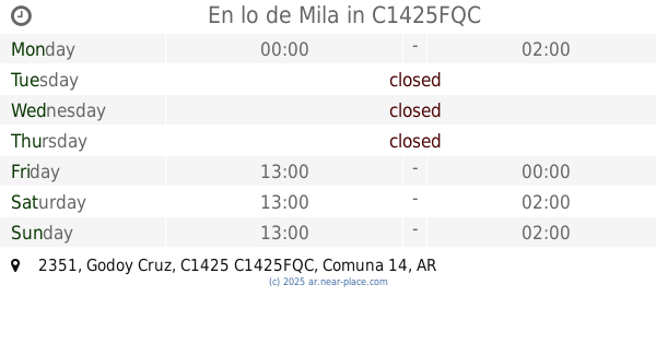
En lo de Mila
Godoy Cruz 2351, C1425FQC
Night club
read more
752 m
NIGHTCLOUD S.A.S
República de la India 2945
Night club
read more
785 m
Peugeot Sva
Guatemala 4649
Night club
read more
798 m
PRAGA CLUB
Nicaragua 5089
Night club
read more
889 m
VDP DVD PFD
Avenida Raúl Scalabrini Ortíz 2372
Night club
read more
893 m
GALA PALERMO
República de la India 3100-3002, C1425FCH
Night club
read more
896 m
Pslermo
C1425ARA, Juan María Gutiérrez 3785-3799
Night club
read more
909 m
Fernando Beytrison
Avenida Raúl Scalabrini Ortíz 2290
Night club
read more
945 m
Espacio Darwin
Night club
read more
962 m
Discoteca Un Gallo Para Esculapio
Uriarte 1791
Night club
read more
975 m
Liquid Bar
Avenida Santa Fe 3651
Night club
read more
1.017 km
The Clubhouse
Costa Rica 4651, Buenos Aires
Night club
read more
1.046 km
Möoi
Costa Rica 5468
Night club
read more
1.051 km
Discoteca Mambo las Canita
Báez 247
Night club
read more
1.102 km
Cena Show Disco Bar Boliche
Juan B Justo y El Salvador, Buenos Aires
Night club
read more
1.12 km
Cena Show Capital
Avenida Juan Bautista Justo 1414
Night club
read more
1.159 km
Disco Bar Brujas
1640, DGB, Jorge Luis Borges
Night club
read more
1.176 km
Rosebar After Office
Honduras 5440
Night club
read more
1.18 km
Kika Boliche
Honduras 5339
Night club
read more
1.234 km
Thelonious Club
Jerónimo Salguero 1884
Night club
read more
📑
all categories
Accounting
Administrative area level 1
Administrative area level 2
Airport
Amusement park
Aquarium
Art gallery
Atm
Bakery
Bank
Bar
Beauty salon
Bicycle store
Book store
Bowling alley
Bus station
Cafe
Campground
Car dealer
Car rental
Car repair
Car wash
Casino
Cemetery
Church
City hall
Clothing store
Colloquial area
Convenience store
Country
Courthouse
Dentist
Department store
Doctor
Electrician
Electronics store
Embassy
Establishment
Finance
Fire station
Florist
Food
Funeral home
Furniture store
Gas station
General contractor
Grocery or supermarket
Gym
Hair care
Hardware store
Health
Hindu Temple
Home goods store
Hospital
Insurance agency
Intersection
Jewelry store
Laundry
Lawyer
Library
Light rail station
Liquor store
Local government office
Locality
Locksmith
Lodging
Meal delivery
Meal takeaway
Mosque
Movie rental
Movie theater
Moving company
Museum
Natural feature
Neighborhood
Night club
Painter
Park
Parking
Pet store
Pharmacy
Physiotherapist
Place of worship
Plumber
Point of interest
Police
Political
Post office
Premise
Real estate agency
Restaurant
Roofing contractor
Route
Rv park, camping
School
Shoe store
Shopping mall
Spa
Stadium
Storage
Store
Subpremise
Subway station
Supermarket
Synagogue
Taxi stand
Train station
Transit station
Travel agency
University
Veterinary care
Zoo
sublocality level 1
sublocality level 3
↑