Park nearby Boulevard Corrientes
Coronavirus disease (COVID-19) Situation
confirmed cases
10128845
deaths
130841
Argentina
Park nearby Boulevard Corrientes
Boulevard Corrientes
Unnamed Road, CABA, Argentina
contacts phone
:
+54
website:
www.buenosaires.gob.ar
Latitude:
-34.587905
, Longitude:
-58.4531194
larger map & directions
read more
nearest Park
329 m
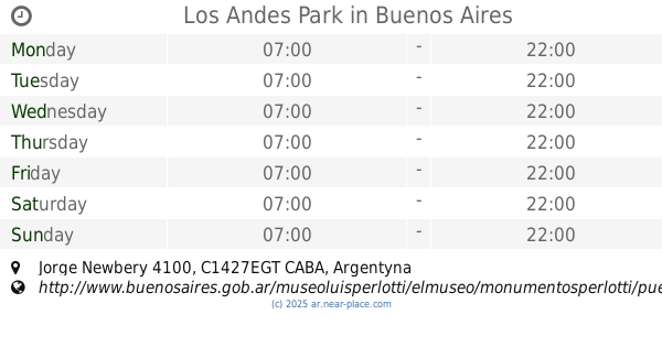
Los Andes Park
Jorge Newbery 4100
Park
read more
397 m
Lineal Jorge Newbery Park
C1427EGL, Jorge Newbery 4511-4577
Park
read more
397 m
Parque Lineal Jorge Newbery
C1427EGL, Jorge Newbery 4511-4577
Park
read more
712 m
Plazoleta Colonia Esperanza
y, Av. Córdoba & Av. Federico Lacroze
Park
read more
771 m
Salvá La Reserva del Puerto
Zabala 3873
Park
read more
828 m
Elcano Park
Avenida Elcano 4352-4390
Park
read more
828 m
Parque Elcano
Avenida Elcano 4352-4390
Park
read more
841 m
Plazoleta de la Amistad
Avenida Dorrego 361-389
Park
read more
923 m
Plaza Elcano
Avenida Elcano 4352-4634
Park
read more
937 m
Plaza Elcano (Del Cementerio)
Avenida Elcano 4352-4634
Park
read more
962 m
Blue Gardenia BG
Delgado 714
Park
read more
1.049 km
Plaza Clemente
Park
read more
1.062 km
Plaza Mafalda
Conde 145
Park
read more
1.22 km
Square August 25
14 de Julio 1150
Park
read more
1.22 km
Plaza 25 de Agosto
14 de Julio 1150
Park
read more
1.305 km
Plaza Antonio Malaver
Atanasio Girardot, Libertad
Park
read more
1.408 km
Palacio Padula
Añasco 2456
Park
read more
1.445 km
Plaza de los Colegiales
C1426DBC, Teniente Benjamín Matienzo 2901-2999
Park
read more
1.536 km
AAJJ HOCKEY PATINES
1281, Punta Arenas 1251
Park
read more
1.673 km
Juegos Infantiles
Crámer 682-602, C1426ANN
Park
read more
1.682 km
Plaza Santos Dumont
Santos Dumont 2719
Park
read more
1.683 km
Plaza Zarraga
3339, C1426EKA, Zárraga 3319
Park
read more
1.702 km
Jardín República de Filipinas
de los Incas entre Crámer y Av C1427DNA, Avenida Álvarez Thomas, Buenos Aires
Park
read more
2.005 km
PLAZA GRAL. BENITO NAZAR
Olaya
Park
read more
2.076 km
Parque La Isla de La Paternal
Argentina
Park
read more
📑
all categories
Accounting
Administrative area level 1
Administrative area level 2
Airport
Amusement park
Aquarium
Art gallery
Atm
Bakery
Bank
Bar
Beauty salon
Bicycle store
Book store
Bowling alley
Bus station
Cafe
Campground
Car dealer
Car rental
Car repair
Car wash
Casino
Cemetery
Church
City hall
Clothing store
Colloquial area
Convenience store
Country
Courthouse
Dentist
Department store
Doctor
Electrician
Electronics store
Embassy
Establishment
Finance
Fire station
Florist
Food
Funeral home
Furniture store
Gas station
General contractor
Grocery or supermarket
Gym
Hair care
Hardware store
Health
Hindu Temple
Home goods store
Hospital
Insurance agency
Intersection
Jewelry store
Laundry
Lawyer
Library
Light rail station
Liquor store
Local government office
Locality
Locksmith
Lodging
Meal delivery
Meal takeaway
Mosque
Movie rental
Movie theater
Moving company
Museum
Natural feature
Neighborhood
Night club
Painter
Park
Parking
Pet store
Pharmacy
Physiotherapist
Place of worship
Plumber
Point of interest
Police
Political
Post office
Premise
Real estate agency
Restaurant
Roofing contractor
Route
Rv park, camping
School
Shoe store
Shopping mall
Spa
Stadium
Storage
Store
Subpremise
Subway station
Supermarket
Synagogue
Taxi stand
Train station
Transit station
Travel agency
University
Veterinary care
Zoo
sublocality level 1
sublocality level 3
↑