Park nearby Frida Kahlo
Coronavirus disease (COVID-19) Situation
confirmed cases
10128845
deaths
130841
Argentina
Park nearby Frida Kahlo
Frida Kahlo
4602-4700, Avenida Salvador María del Carril, C1419, Comuna 11, Buenos Aires, AR Argentina
contacts phone
:
+54
Latitude:
-34.6041744
, Longitude:
-58.5200859
larger map & directions
read more
nearest Park
124 m
Eduardo Mansilla
Villa Devoto
Park
read more
328 m
César Vallejo
Avenida Salvador María del Carril 4418-4470
Park
read more
550 m
Estacion Devoto Park
Ricardo Gutiérrez 4302
Park
read more
550 m
Parque De La Estacion Devoto
Ricardo Gutiérrez 4302
Park
read more
565 m
Hugo del Carril
Villa Devoto
Park
read more
628 m
Edgardo Donato
Villa Devoto
Park
read more
664 m
Plaza Rep. Árabe Siria
Asunción 4221
Park
read more
686 m
García Lorca
Avenida Lincoln
Park
read more
691 m
Plazoleta Líbano
C1419BKE, Gualeguaychú 3701-3799
Park
read more
716 m
Jardin de la Plaza
Desaguadero 3441
Park
read more
721 m
Pablo Neruda
C1419HAU, Avenida Salvador María del Carril 4102-4200
Park
read more
723 m
Plaza Rgto. de Caballería Husares de Pueyrredón
C1419BIB, Benjamín J. Lavaisse 3802-3900
Park
read more
741 m
Plaza Tte. Gral. Pablo Ricchieri
Avenida Francisco Beiró 4800
Park
read more
778 m
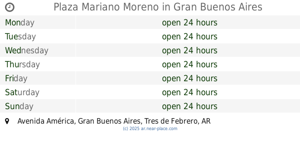
Plaza Mariano Moreno
Avenida América, Gran Buenos Aires
Park
read more
791 m
Violeta Parra
Villa Devoto
Park
read more
892 m
Plaza Arenales
Mercedes 4058
Park
read more
908 m
Isidoro Gil
Chivilcoy 3892
Park
read more
926 m
N. Fontenla
C1419BDR, Chivilcoy 4340
Park
read more
942 m
J. Neglia
C1419BDT, Chivilcoy 4402-4500
Park
read more
957 m
Onorio Stoppani
C1419BDC, Chivilcoy 3665
Park
read more
981 m
Paseo de Los Encuentros
Chivilcoy 3515
Park
read more
1.004 km
Plazoleta Zoe
Chivilcoy 4501
Park
read more
1.05 km
Germán Rozenmacher
C1419HAR, Avenida Salvador María del Carril 3850
Park
read more
1.054 km
M. Borowsky
Chivilcoy 4602-4666
Park
read more
1.2 km
Antonio Berni
Avenida Salvador María del Carril 3774, C1419HAQ
Park
read more
📑
all categories
Accounting
Administrative area level 1
Administrative area level 2
Airport
Amusement park
Aquarium
Art gallery
Atm
Bakery
Bank
Bar
Beauty salon
Bicycle store
Book store
Bowling alley
Bus station
Cafe
Campground
Car dealer
Car rental
Car repair
Car wash
Casino
Cemetery
Church
City hall
Clothing store
Colloquial area
Convenience store
Country
Courthouse
Dentist
Department store
Doctor
Electrician
Electronics store
Embassy
Establishment
Finance
Fire station
Florist
Food
Funeral home
Furniture store
Gas station
General contractor
Grocery or supermarket
Gym
Hair care
Hardware store
Health
Hindu Temple
Home goods store
Hospital
Insurance agency
Intersection
Jewelry store
Laundry
Lawyer
Library
Light rail station
Liquor store
Local government office
Locality
Locksmith
Lodging
Meal delivery
Meal takeaway
Mosque
Movie rental
Movie theater
Moving company
Museum
Natural feature
Neighborhood
Night club
Painter
Park
Parking
Pet store
Pharmacy
Physiotherapist
Place of worship
Plumber
Point of interest
Police
Political
Post office
Premise
Real estate agency
Restaurant
Roofing contractor
Route
Rv park, camping
School
Shoe store
Shopping mall
Spa
Stadium
Storage
Store
Subpremise
Subway station
Supermarket
Synagogue
Taxi stand
Train station
Transit station
Travel agency
University
Veterinary care
Zoo
sublocality level 1
sublocality level 3
↑