Park nearby Lares Canning
Coronavirus disease (COVID-19) Situation
confirmed cases
10128845
deaths
130841
Argentina
Park nearby Lares Canning
Lares Canning
Ruta Provincial 52, Tristan Suárez, Ezeiza, AR Argentinien
contacts phone
:
+54 11 4295-8357
website:
www.laresdecanning.com
Latitude:
-34.93151
, Longitude:
-58.521624
larger map & directions
read more
nearest Park
2.502 km
Estancia de las Brujerias HC
Ezeiza
Park
read more
5.059 km
Campo De Deportes Marista Colegio Inmaculada
3899,, José Champagnat 3699, Canning
Park
read more
5.21 km
Saint Thomas Country Club
Boulevard Saint Thomas, Esteban Echeverría
Park
read more
5.328 km
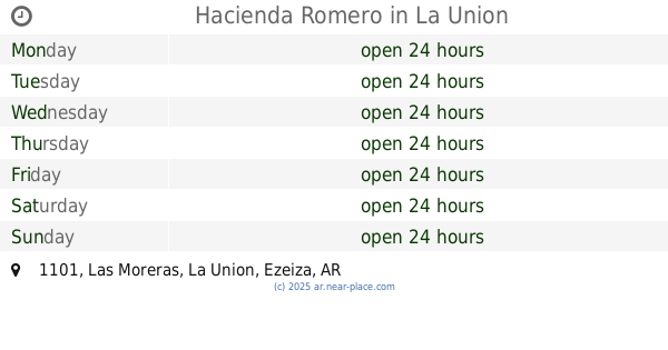
Hacienda Romero
1299,, Las Moreras 1101, La Union
Park
read more
5.627 km
Plaza Barrio Del Plata
Carlos Spegazzini
Park
read more
6.003 km
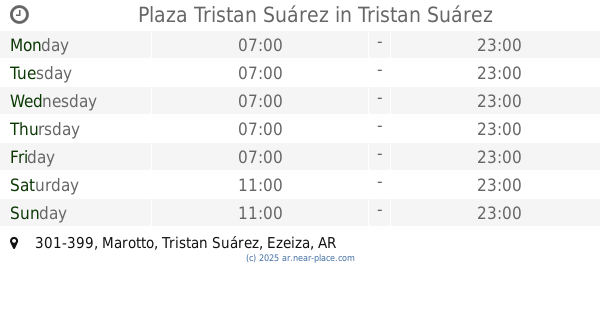
Plaza Tristan Suárez
Marotto 301-399, Tristan Suárez
Park
read more
6.6 km
Club De Campo Horizontes Al Sur
Ruta Provincial 16, Guernica
Park
read more
6.804 km
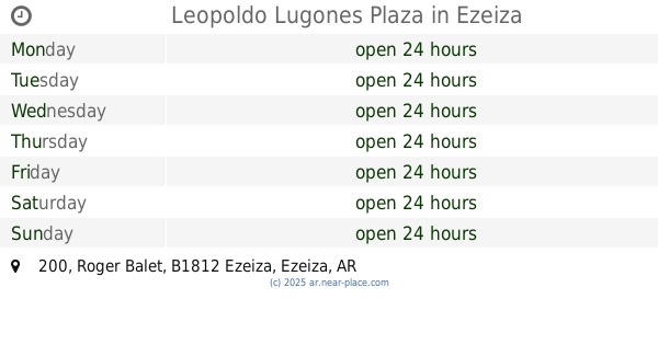
Leopoldo Lugones Plaza
Roger Balet 200, Ezeiza
Park
read more
8.557 km
Plaza Municipal
Presidente Peron 202-300, Ezeiza
Park
read more
12.649 km
Plaza San Pablo
B1862BOH, Calle 124 301-397, Guernica
Park
read more
13.464 km
Plaza Bartolome Mitre
549, Avenida Sofia Terrero de Santamarina 499, Monte Grande
Park
read more
13.785 km
Plaza Alfonsina Storni
Park
read more
15.244 km
Barrio Santa ANA
998,, Provincia de Santa Fe 800, Glew
Park
read more
15.392 km
Football Club Burzaco
2399 B1852EVE, Vallejos 2301, Burzaco
Park
read more
15.484 km
Lis Alvarado
Vito Dumas 292, Virrey del Pino
Campground
Lodging
Park
Point of interest
Establishment
read more
15.784 km
electro Termi
1299,, Eva Duarte de Perón 1199, Burzaco
Park
read more
15.871 km
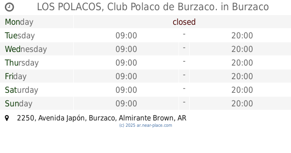
LOS POLACOS, Club Polaco de Burzaco.
Avenida Japón 2250, Burzaco
Campground
Lodging
Park
Point of interest
Establishment
read more
16.595 km
Plaza San fransisco De Asis
Doctor Jorge Melber 1802-1900, Llavallol
Park
read more
16.922 km
Plaza De Oro Verde
B1763EVW, Bacigaluppi 3599, Virrey del Pino
Park
read more
17.67 km
Fotográfico Campo Cristal Park
Virrey del Pino
Park
read more
17.67 km
Parque Fotográfico Campo Cristal
Virrey del Pino
Park
read more
19.129 km
Plazoleta Clemente
Benigno Macias 568, Adrogué
Park
read more
19.601 km
Plaza Azopardo
Diagonal Almirante Brown 1002, Adrogué
Park
read more
19.676 km
Camping Grafico 7 de Mayo
594, B1849BHD, Calle Pedro Benjamín Aquino 460, Claypole
Park
read more
20.499 km
Plazoleta del Bombero R. Calzada
Rafael Calzada
Park
read more
📑
all categories
Accounting
Administrative area level 1
Administrative area level 2
Airport
Amusement park
Aquarium
Art gallery
Atm
Bakery
Bank
Bar
Beauty salon
Bicycle store
Book store
Bowling alley
Bus station
Cafe
Campground
Car dealer
Car rental
Car repair
Car wash
Casino
Cemetery
Church
City hall
Clothing store
Colloquial area
Convenience store
Country
Courthouse
Dentist
Department store
Doctor
Electrician
Electronics store
Embassy
Establishment
Finance
Fire station
Florist
Food
Funeral home
Furniture store
Gas station
General contractor
Grocery or supermarket
Gym
Hair care
Hardware store
Health
Hindu Temple
Home goods store
Hospital
Insurance agency
Intersection
Jewelry store
Laundry
Lawyer
Library
Light rail station
Liquor store
Local government office
Locality
Locksmith
Lodging
Meal delivery
Meal takeaway
Mosque
Movie rental
Movie theater
Moving company
Museum
Natural feature
Neighborhood
Night club
Painter
Park
Parking
Pet store
Pharmacy
Physiotherapist
Place of worship
Plumber
Point of interest
Police
Political
Post office
Premise
Real estate agency
Restaurant
Roofing contractor
Route
Rv park, camping
School
Shoe store
Shopping mall
Spa
Stadium
Storage
Store
Subpremise
Subway station
Supermarket
Synagogue
Taxi stand
Train station
Transit station
Travel agency
University
Veterinary care
Zoo
sublocality level 1
sublocality level 3
↑