Park nearby Plaza Lavalle
Coronavirus disease (COVID-19) Situation
confirmed cases
10128845
deaths
130841
Argentina
Park nearby Plaza Lavalle
Plaza Lavalle
1145, Avenida Corrientes, C1043, Comuna 1, Buenos Aires, AR Argentinien
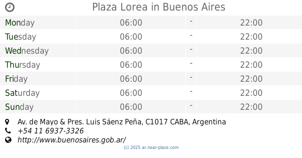
contacts phone
:
+54
website:
www.buenosaires.gob.ar
Latitude:
-34.6020577
, Longitude:
-58.384511
larger map & directions
read more
nearest Park
175 m
Vatican Square
Viamonte
Park
read more
306 m
BA green
Avenida Corrientes 1035
Park
read more
325 m
La Arbolada de Capilla
4, San Martín 170
Park
read more
344 m
Lupita (La Plata)
Avenida Corrientes 1100
Park
read more
388 m
Plaza Provincia de Santa Cruz
Park
read more
569 m
Plaza Pcia de Río Negro
Park
read more
581 m
Buenos Aires
San Nicolas
Park
read more
707 m
Dr. Joaquín Zabala
C1008AAD, Suipacha 120
Park
read more
720 m
Plaza Province of Neuquen
Park
read more
726 m
Plaza Petronila Rodríguez
Park
read more
727 m
Plaza Provincia de Tucumán
Park
read more
740 m
Plazoleta Rosita Quiroga
Avenida Presidente Roque Sáenz Peña 782-800
Park
read more
766 m
Rgto. 1º de Infantería Patricios
San Nicolas
Park
read more
806 m
Plaza Jardín de los Maestros
Park
read more
849 m
Espacio Verde
Avenida Rivadavia 1583
Park
read more
850 m
Plaza Lorea
Av. de Mayo & Pres. Luis Sáenz Peña
Park
read more
857 m
Buenos Aires
Monserrat
Park
read more
862 m
Plaza Roberto Arlt
Rivadavia y Esmeralda
Park
read more
868 m
Plaza Rodríguez Peña
C1021 CABA, Argentina
Park
read more
954 m
Paseo Provincias Argentinas
1251, C1010AAY, Cerrito 1201
Park
read more
968 m
Plaza Provincia de La Rioja
Park
read more
974 m
Plazoleta Tte. de Navío Cándido de Lasala
754,C1006, Avenida Santa Fe 716
Park
read more
1.004 km
Congressional Plaza
Buenos Aires
Park
read more
1.02 km
Maipú park
Buenos Aires
Park
read more
1.027 km
Plazoleta Juvenilla
Marcelo Torcuato de Alvear 628
Park
read more
📑
all categories
Accounting
Administrative area level 1
Administrative area level 2
Airport
Amusement park
Aquarium
Art gallery
Atm
Bakery
Bank
Bar
Beauty salon
Bicycle store
Book store
Bowling alley
Bus station
Cafe
Campground
Car dealer
Car rental
Car repair
Car wash
Casino
Cemetery
Church
City hall
Clothing store
Colloquial area
Convenience store
Country
Courthouse
Dentist
Department store
Doctor
Electrician
Electronics store
Embassy
Establishment
Finance
Fire station
Florist
Food
Funeral home
Furniture store
Gas station
General contractor
Grocery or supermarket
Gym
Hair care
Hardware store
Health
Hindu Temple
Home goods store
Hospital
Insurance agency
Intersection
Jewelry store
Laundry
Lawyer
Library
Light rail station
Liquor store
Local government office
Locality
Locksmith
Lodging
Meal delivery
Meal takeaway
Mosque
Movie rental
Movie theater
Moving company
Museum
Natural feature
Neighborhood
Night club
Painter
Park
Parking
Pet store
Pharmacy
Physiotherapist
Place of worship
Plumber
Point of interest
Police
Political
Post office
Premise
Real estate agency
Restaurant
Roofing contractor
Route
Rv park, camping
School
Shoe store
Shopping mall
Spa
Stadium
Storage
Store
Subpremise
Subway station
Supermarket
Synagogue
Taxi stand
Train station
Transit station
Travel agency
University
Veterinary care
Zoo
sublocality level 1
sublocality level 3
↑